
The University of Tulsa
Mountain Cedar Pollen Forecast
Metropolitan Area |
Exposure Risk |
|
Dallas/Fort Worth |
High |
|
Austin |
High |
|
San Antonio |
High |
Date Issued: 6 January 2012
Mountain Cedar Location(s): Edwards Plateau, Texas
Regional Weather: Friday, January 6 TX/OK:
The region will enjoy mostly sunny skies to the east and sunny skies over the Edwards Plateau today. To the north
in Oklahoma the southerly winds will bring increasing cloudiness. In addition, the southerly breezes will bring
patchy morning fog to the communities surrounding the Plateau. Temperatures across the region will remain unseasonably
warm with highs in the mid 70s. To the north in Oklahoma todays highs will be in the upper 60s. Winds will
remain from the south to southwest at moderate levels. Tonight the areas from Dallas/Fort Worth north into Oklahoma
will have partly cloudy skies. Tonights low temperatures across the region will be seasonal with only the furthest
western areas flirting with freezing conditions. Elsewhere on the Plateau lows will be in the mid to upper 30s
and the surrounding communities will only fall into the upper 40s. The warm nighttime temperatures and southerly
breezes will result in patchy fog in the edge communities tomorrow morning. Tomorrow to the north, partly cloudy
skies will occur throughout the day. To the south and around the Edwards Plateau sunny to mostly sunny conditions
will occur, whereas partly cloudy skies will be building towards the west over the Edwards Plateau. High temperatures
tomorrow will cool with mid 50s across Oklahoma and low to mid 60s across Texas. The southernmost edge communities
are expected to be in the low 70s. Winds will switch tomorrow coming from the north at moderate to light levels.
Towards the evening and overnight partly cloudy to mostly cloudy skies will build towards the north. Low temperatures
will be seasonal again in the upper 30s across the Edwards Plateau and in Oklahoma with upper 40s in the metropolitan
communities in northern Texas and surrounding the Edwards Plateau. Winds will be light switching back coming
from the north, except for the Edwards Plateau communities where a southerly breeze will return.
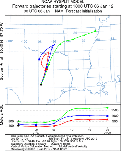
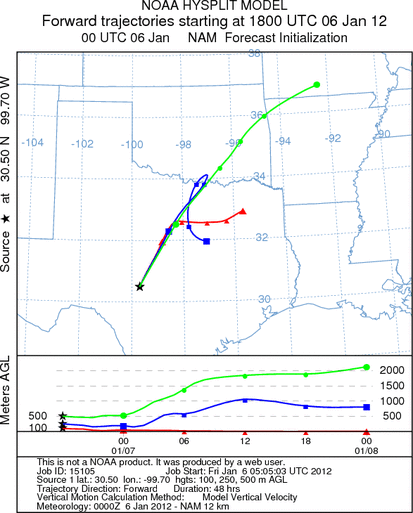
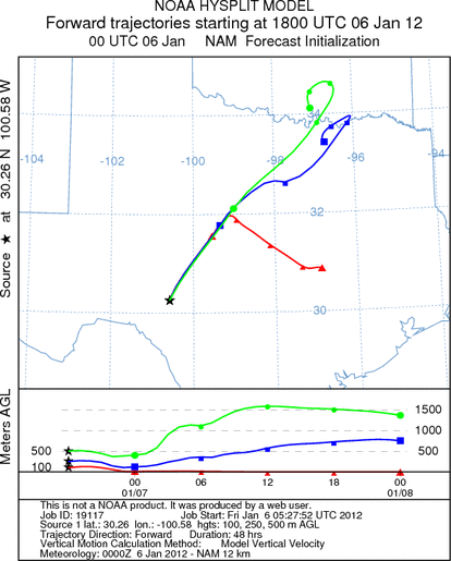
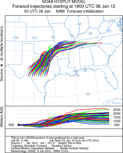
Trajectory weather: Air mass trajectories at mid to upper elevations over the Edwards Plateau move northeasterly
heading over north central Texas and then across southeastern Oklahoma into Arkansas. Winds across the region
will be light to moderate and from the southwest. The air appears to be initially stable with most of the trajectories
gaining or loosing little altitude along their flight pathway. However, as the trajectories reach northern Texas
and Oklahoma it will become more buoyant and the potential for long-distance travel increases. Up to that point
movement at the surface levels should remove significant amounts of pollen from the atmosphere. In addition as
long as the pollen struggles to get into the upper elevations of the atmosphere their travel will be relatively
limited. Warm conditions will occur across the region with increased humidity. Temperatures in areas with tree
populations will be close to or above the 70 degree mark for their high temperature reading . Tonight winds will
calm but remain from the southwest. The southwesterly breezes will end tonight as northerly winds move across
the area. Light to moderate winds from the north will occur across the region tomorrow. Southerly winds return
tomorrow night to the Edwards Plateau.
OUTLOOK: *** Significant Threat today and Significant Threat Tomorrow *** Good
conditions for pollen release today and tomorrow with good conditions today and tomorrow for entrainment and transport.
Clear skies with lots of sun will occur today then cooling a bit tomorrow with temperatures in the mid 70s across
the region today and into the mid to low 60s tomorrow. Today moderate winds will occur across the area coming
from the south and southwest. Tomorrow winds will have switched coming from the north. High levels of Juniperus
ashei pollen are were reported yesterday and with warm somewhat humid conditions in most areas today, high levels
of polle release are expected. The highest levels continue to be recorded in the edge communities from Waco to
Austin and onward toward San Antonio. In areas surrounding the Edwards Plateau high levels will again be common
as winds will move off the Plateau. With the southwesterly winds communities to the north and in southeastern
Oklahoma will be effected by high pollen levels. Conditions over the next two days are very suitable for cone
ripening and release. Tomorrow will cool by 5 to 10 degrees and of the two day will be less optimal for pollen
release that today.
Trajectory Start (s) (shown by *
on map): Austin, TX; Junction, TX; Sonora, TX.
AUSTIN
JUNCTION
SONORA
EDWARDS PLATEAU COMPOSITE
Prepared by: Estelle
Levetin (Faculty of Biological
Science, The
University of Tulsa, 800 S. Tucker Dr., Tulsa, OK 74104) and ) and Peter
K Van de Water (Department of Earth and Environmental Science, California State University Fresno,
2576 East San Ramon Avenue, M/S ST24, Fresno CA 93740-8039). This forecast gives the anticipated future track of
released Mountain Cedar pollen, weather conditions over the region and along the forecast pathway, and an estimated
time of arrival for various metropolitan areas.
Questions: Aerobiology Lab e-mail: pollen@utulsa.edu
Return to Forecasting Home Page