The University of Tulsa
Mountain Cedar Pollen Forecast

Metropolitan Area |
Exposure Risk |
|
Oklahoma City |
Low / Low |
|
Tulsa |
Low / Low |
|
St. Louis MO |
Low / Low |
Date Issued: 7 January 2012
Mountain Cedar Location(s): Arbuckle Mountains, OK
Regional Weather: Saturday, January 7/ Sunday, January
8 TX/OK: Across the region the weather today and tomorrow will be degrading towards the chance of rain
Sunday night. Conditions will remain seasonally warm but clouds will begin to build and precipitation is expected
tomorrow night. In Oklahoma and across the western areas of the Edwards Plateau partly cloudy skies will start
to build this morning on northerly breezes. To the north the high temperatures will reach into the mid 50s today,
whereas to the south a return to the 60s is expected in most areas. The southernmost edge communities will flirt
with near 70 degrees again this afternoon. Winds will be light from the north coming from the northwest. Tonight
clouds will begin to thicken and winds will die being very light in most areas. Tonight the low temperature will
be moderated by the cloud cover and most areas will be in the 40s. Areas of the western most Edwards Plateau
will get into the 30s but freezing conditions are not expected anywhere across the region. Tomorrow will dawn
with mostly cloudy and cloudy conditions. To the north in Oklahoma sprinkles are a possibility. Winds will continue
to be from the north to northeast at mild to moderate levels. High temperatures will only be in the upper 40s
and low 50s on Sunday. To the south, cloudy conditions and mild temperatures will occur. Temperatures will be
in the 60s across the region with winds from the east and southeast. The surrounding communities will have light
winds and in the southern communities there will be a 20% chance of rain during the day. High temperatures on
Sunday will be in the mid 60s in most regions. Sunday night the skies build to cloudy conditions with a significant
chance of rain across the Edwards Plateau and in the surrounding communities. Winds will build to moderate conditions
from the east and northeast and temperatures will be in the 40s and 50s. Cooler lows will occur in the western
Edwards Plateau communities while lows in the mid to low 50s will occur in the edge communities surrounding the
Edwards Plateau. The chance of rain in the areas surrounding the Plateau will be 60% to 70% . Communities in
the western region of the Edwards Plateau will have a 40% chance of rain overnight.
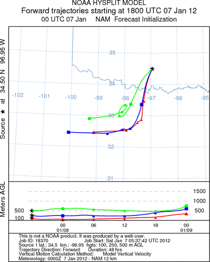
Trajectory weather: Air mass trajectories from southern Oklahoma move south and southwestward heading over
north Texas.. Winds across the region will be light from the north and northeast. In southern Oklahoma, winds
will move primarily towards the southwest. The air appears to be stable with most of the trajectories gaining
little to no altitude along their flight pathway. Temperatures today will be in the mid-50s with partly cloudy
skies. The skies will continue to build towards cloudy conditions tomorrow, with low temperatures tonight in the
mid 30s in central Oklahoma and mid 40s along the border region. Tonights winds will calm from their northeasterly
direction. Tomorrow morning sprinkles area forecast across the region, with a 20% to 30% chance of rain tomorrow
night. Temperatures will remain cool with highs in the 40s and 50s. Winds will increase slightly tomorrow and
then tomorrow night, maintaining their direction from the northeast.
OUTLOOK : *** Moderate Threat today and Low Threat Tomorrow
*** Moderate conditions for pollen release today and poor conditions tomorrow with Moderate conditions today
and poor conditions tomorrow for entrainment and transport. Cloudy skies today with temperatures in the mid 50s
will provide moderate conditions for pollination. However, winds will be at light from the northeast and the atmosphere
is stable. Conditions suggest that at the lowest levels of the atmosphere, winds will move any entrained pollen
towards the southwest over northernmost Texas. However, the winds will move along the pathway slowly and the air
is dense with increasing humidityu, thus most pollen should fall out of the airstream fairly close to the source.
Therefore, entrainment and travel conditions will be moderate today decaying to poor tomorrow. Tomorrow winds
will maintain their northeast to southwest direction at light levels. In the border region where the tree population
occurs, only 10 to 15 mile per hour winds are forecast at their height, and lower levels during other times. Tomorrow
temperatures will only climb into the upper 40s and low 50s. Moderate conditions exist for pollination today
but fall off becoming poor tomorrow.
Trajectory Start (s) (shown by black
star on map): Davis, OK.
Prepared by: Estelle
Levetin
(Faculty
of Biological Science, The University of Tulsa, 800 S. Tucker Dr., Tulsa, OK 74104) and Peter
K Van de Water
(Department of Earth and Environmental Science, California State University Fresno, 2576 East San Ramon Avenue,
M/S ST24, Fresno CA 93740-8039). This forecast gives the anticipated future track of released Mountain Cedar pollen,
weather conditions over the region and along the forecast pathway, and an estimated time of arrival for various
metropolitan areas.
Questions: Aerobiology Lab e-mail: pollen@utulsa.edu
Return to Forecasting Home Page