
The University of Tulsa
Mountain Cedar Pollen Forecast
Metropolitan Area |
Exposure Risk |
|
Dallas/Fort Worth |
Low |
|
Austin |
Moderate |
|
San Antonio |
Moderate |
Date Issued: 10 January 2012
Mountain Cedar Location(s): Edwards Plateau, Texas
Regional Weather: Tuesday, January 10 TX/OK:
Across the region the weather will begin to clear. Areas to the north have a chance for rain in the morning with
a 50% to 60% chance of precipitation in northern Texas and southern Oklahoma. To the south mostly cloudy conditions
will occur in the morning but it will soon break towards mostly sunny conditions by the afternoon. The areas surrounding
the Edwards Plateau will clear faster than on the Plateau itself. To the far west, San Angelo will still have
a 20% chance of rain early this morning. Once the moisture leaves the area temperatures are expected to rise into
the upper 40s in north Texas and southern Oklahoma to the mid 50s along the eastern side of the Edwards Plateau
and its surrounding edge communities. San Antonio is expected to get into the low 60s this afternoon. However,
cold air will still be entrenched across the western side of the Plateau with highs barely reaching into the 50s
in San Angelo as well as Sonora. Winds will be moderate (10-20 mph) with strong gust (25 mph) from the northwest
throughout the day, coming from the west tonight. Overnight partly cloudy skies in the north will grade towards
mostly cloudy skies in the edge communities and mostly clear to clear skies over the Edwards Plateau. Temperatures
will be in the mid to low thirties region wide, except in western Texas where the upper 20s are expected. Tomorrow
skies will return to sunny conditions across most of the region. Winds will remain at moderate levels building
towards the afternoon. The westerly winds from the previous night will shift further south causing the wind pattern
to blow from the southwest. Temperatures will be in the upper 50s across southern Oklahoma and northern Texas.
The surrounding communities will reach into the upper 60s and flirt with the low 70s in Junction as well as
San Antonio. To the west temperatures will climb into the mid to upper 60s. Across the region tomorrow night
will be partly cloudy with temperatures in the mid to upper 30s in the urban centers and 5 to 10 degrees cooler
across the western Edwards Plateau and northward into southern Oklahoma. Winds will switch from the southwestern
winds during the day to moderate winds coming from the north.
Trajectory weather: Air mass trajectories over the Edwards Plateau move almost due east on moderate westerly
winds gusting to levels of around 25 miles per hour. Poor conditions will exist during the day for pollination
as yesterdays showers and rainy conditions will have washed much of the pollen out of the air and off of the trees.
The beginning of warming tomorrow will once again bring the possibility of pollen once again in the atmosphere.
The system that moved through the area brought cold air over the region thus the trajectories travel at or near
the ground downwind from their starting points. Tomorrow conditions will improve with many areas back into the
mid to upper 60s, under sunny skies. Winds tomorrow will be from the southwest therefore any entrained pollen
should flow towards the northeast. Therefore Wednesday is the next day to expect significant amounts of pollen
in the atmosphere.
OUTLOOK: *** Low Threat today and Moderate Threat Tomorrow
*** Poor conditions for pollen release today with a return of good conditions tomorrow with poor conditions
today and tomorrow for entrainment and transport. Skies will be cloudy after Monday and Monday nights precipitation.
Across the region poor conditions for pollen release, entrainment and travel will exist. Conditions are improving
as we go through the day, therefore tomorrow will show better conditions with temperatures once again climbing
into the 60s and heading towards the 70s. However, the atmosphere will remain relatively heavy thus entrainment
and travel will lag before it becomes conducive to downwind transport.
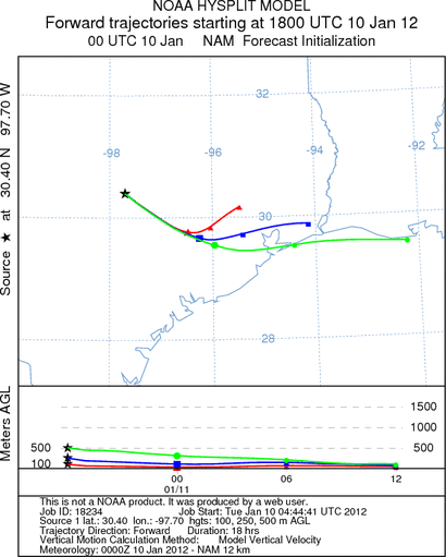
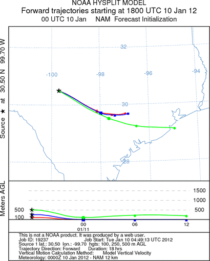
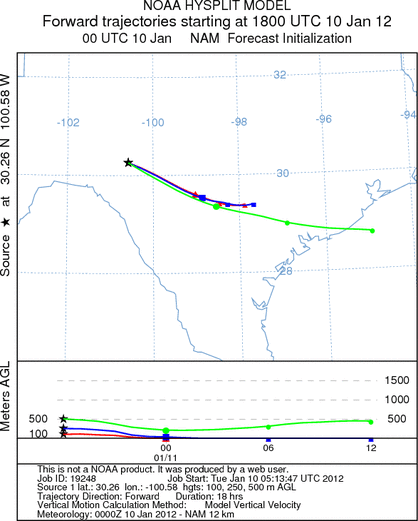
Trajectory Start (s) (shown by *
on map): Austin, TX; Junction, TX; Sonora, TX.
AUSTIN
JUNCTION
SONORA
EDWARDS PLATEAU COMPOSITE
Prepared by: Estelle
Levetin (Faculty of Biological
Science, The
University of Tulsa, 800 S. Tucker Dr., Tulsa, OK 74104) and ) and Peter
K Van de Water (Department of Earth and Environmental Science, California State University Fresno,
2576 East San Ramon Avenue, M/S ST24, Fresno CA 93740-8039). This forecast gives the anticipated future track of
released Mountain Cedar pollen, weather conditions over the region and along the forecast pathway, and an estimated
time of arrival for various metropolitan areas.
Questions: Aerobiology Lab e-mail: pollen@utulsa.edu
Return to Forecasting Home Page