The University of Tulsa
Mountain Cedar Pollen Forecast

Metropolitan Area |
Exposure Risk |
|
Oklahoma City |
Low |
|
Tulsa |
Low |
|
St. Louis MO |
Low |
Date Issued: 11 January 2012
Mountain Cedar Location(s): Arbuckle Mountains, OK
Regional Weather: Wednesday, January 11 TX/OK:
Across the region the weather will continue to improve from the recent rains. To the north partly cloudy skies
will continue with sunny or partly sunny conditions across the remainder of region. This morning ground fog will
be common in the border region from Dallas/Fort Worth towards Oklahoma. Temperatures across Oklahoma will be in
the mid 50s to low 60s. To the south, temperatures will rise into the upper 60s to low 70s. The areas surrounding
the Edwards Plateau will return into the 70s whereas the Plateau itself will top out in the 60s. Although conditions
look to be improving, winds will be from the west to southwest at moderate levels and gusty. To the southwest,
later today changes will begin with winds becoming more westerly as they begin to move towards a more northerly
direction tonight. This evening, partly cloudy skies will return with temperatures in the mid 20s to the north
in Oklahoma and 30s common across Texas. To the west tonights lows will bottom out in the lower 20s, whereas
further east of the Plateau temperatures will stay in the mid 30s. The edge communities will be in the upper
30s and low 40s. Winds will start out from the west, shifting to the northwest and eventually coming from the
north. As this shift occurs winds will increase with gusty conditions. Some areas, especially to the north, will
see wind gusts into the 40 mph range. Tomorrow, cooler conditions will occur with most high temperatures straining
to get into the 50s. Highs tomorrow in central Oklahoma will be in the 30s. Winds will continue from the north
at moderate levels with gusts into the mid 20 mph range. Tomorrow night the areas surrounding the Edwards Plateau
will be partly cloudy, while the remainder of the region will be clear. Temperatures will be very cold with lows
in most areas in the 20s. Areas on the Edwards Plateau will be in the lower 20s whereas other areas will be
in the upper 20s. Winds will calm overnight to light conditions remaining from the north except to the southwest
where a southeasterly wind is a signal of the next shift in weather on its way.
Trajectory weather: Air mass trajectories over southern Oklahoma move southward on northwest winds today.
Conditions will be moderate today for pollination as the high temperature is expected to be in the low 60s.
Morning fog may add additional humidity onto the trees and further delay cones from opening. Tonight temperatures
will drop into the 20s with strong winds as the wind direction switches from the northwest to the north. Tomorrow
much colder conditions will occur with highs barely making it into the upper 30s and low 40s. Winds will be
moderate from the northwest under sunny skies. Tomorrow night clear skies will continue and temperatures will
drop into the teens and low 20s. winds will shift towards the northwest and remain light to moderate.
OUTLOOK: *** Significant Threat today and Low Threat Tomorrow *** Moderate conditions for pollen release
today and poor conditions tomorrow. Good conditions today and poor conditions tomorrow for entrainment and transport.
Skies will be clearing today with warming temperatures as highs are expected in the low 60s. Winds will be light
to moderate and some buoyancy will occur under the warming conditions. Tonight and tomorrow cold air will move
in with very cold conditions tonight, tomorrow and tomorrow night. With the cold air, dense stable air will move
over the region. The cold dense air will result in poor conditions for entrainment and travel.
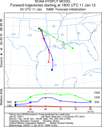
Trajectory Start (s) (shown by black
star on map): Davis, OK.
Prepared by: Estelle
Levetin
(Faculty
of Biological Science, The University of Tulsa, 800 S. Tucker Dr., Tulsa, OK 74104) and Peter
K Van de Water
(Department of Earth and Environmental Science, California State University Fresno, 2576 East San Ramon Avenue,
M/S ST24, Fresno CA 93740-8039). This forecast gives the anticipated future track of released Mountain Cedar pollen,
weather conditions over the region and along the forecast pathway, and an estimated time of arrival for various
metropolitan areas.
Questions: Aerobiology Lab e-mail: pollen@utulsa.edu
Return to Forecasting Home Page