
The University of Tulsa
Mountain Cedar Pollen Forecast
Metropolitan Area |
Exposure Risk |
|
Dallas/Fort Worth |
High |
|
Austin |
High |
|
San Antonio |
High |
Date Issued: 14 January 2012
Mountain Cedar Location(s): Edwards Plateau, Texas
Regional Weather: Saturday, January 14/Sunday, January
15 TX/OK: Across the region the weather will be warming with sunny skies and temperatures in the mid
60s. Winds to the north in Oklahoma will be from the northwest at 10 miles per hour. Winds will shift to a more
northeasterly direction this afternoon. To the south across Texas a southwesterly to southerly wind pattern will
be in place today, tonight, tomorrow and tomorrow night. Winds today will be light to moderate from 5 to 10 miles
per hour. Tonight, the northern areas will remain clear with temperatures in the upper 30s along and south of
the border region. Central Oklahoma will be in the lower 30s. Across central Texas partly to mostly cloudy conditions
will build in tonight with most low temperatures falling into the mid 30s. Warmer conditions will exist in the
southern most communities surrounding the Edwards Plateau with temperatures remaining in the 40s. Winds will
maintain a southerly flow at light levels. Most areas overnight will see winds around 5 miles per hour. Tomorrow,
skies will remain cloudy to mostly cloudy across the Edwards Plateau and in the surrounding communities. High
temperatures will return to the mid 60s in most of these areas and whereas light winds characterized Saturday,
on Sunday winds will become strong from the south. Most areas will see winds begin at 10 to 20 miles per hour
but by the afternoon they will become stronger with many areas seeing gusts at 30 miles per hour. The winds will
slacken to moderate levels tomorrow night. Skies will increase in cloudiness. In turn low temperatures will be
warm with most areas in Texas remaining in the 50s overnight. In southern Oklahoma nighttime temperatures will
just barely get into the 40s. With the southerly breezes and its humidity there is a 20% chance of showers in
the eastern edge communities north towards the border with Oklahoma. The chance of showers will increase region
wide on Monday.
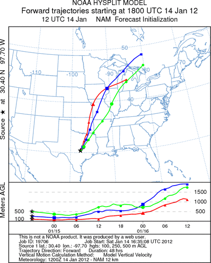
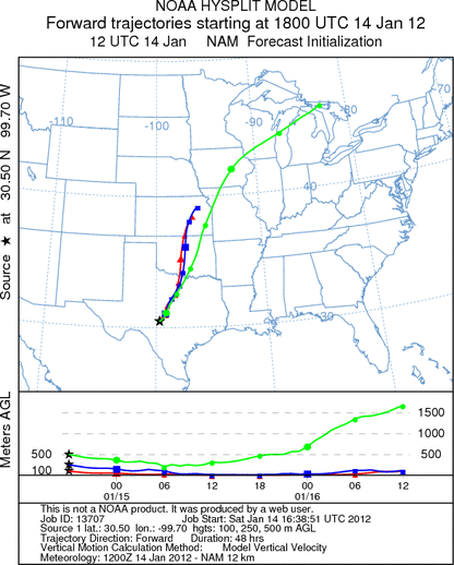
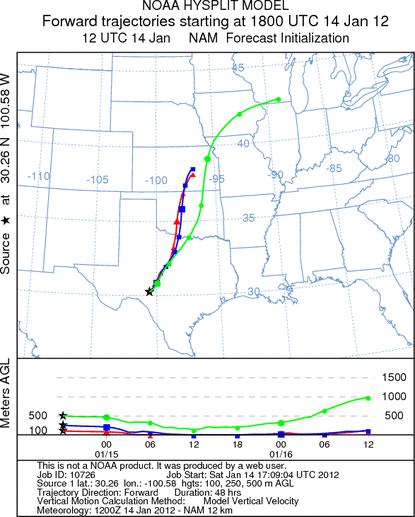
Trajectory weather: Air mass trajectories over the Edwards Plateau will move toward the northeast on southerly
winds at light to moderate levels today and tonight but then more quickly on strong winds tomorrow. These winds
will remain constant today and tomorrow. Temperatures will be in the 60s across the region today and tomorrow.
Tonight temperatures will fall into the 30s but not get below freezing. Tomorrow warm conditions will extend
into the evening hours with low temperatures in the upper 40s and 50s across the region. In the southern surrounding
communities tomorrow night the low will only dip into the upper 50s. Winds from the tree populations will be
flowing from the southwest towards the north to northeast over northern Texas and eastern Oklahoma. At upper elevations,
the trajectories will move rapidly towards the upper mid-west and the Great Lakes area. Sunday night there is
an increasing chance (20%) of rain in the areas surrounding the Edwards Plateau northward towards southern Oklahoma.
This is the beginning of precipitation that will build into Monday.
OUTLOOK: *** Significant Threat today and Significant Threat Tomorrow *** Excellent
conditions for pollen release today and tomorrow with Excellent conditions today and tomorrow for entrainment and
transport. Skies will be sunny today and warm across the region. Winds will be light to moderate today and relax
tonight but then become strong tomorrow. Tonight clouds will move in but temperatures will be above freezing and
then warming another few degrees tomorrow. Warm conditions with strong winds and gusty conditions are perfect
for release, entrainment and transport. The weather pattern is setting up characteristics that during previous
years resulted in significant pollen transport out of the region. With a stable southerly flow communities south
of the Juniper populations should not see significant concentrations, but those areas to the north will be heavily
impacted. The trajectories show that the impact will be in north central Texas (Dallas/Fort Worth regional area),
across eastern Oklahoma and northwards into Missouri. At upper elevations, if the pollen gets to those heights,
we could see dispersal across the Great Lakes region.
Trajectory Start (s) (shown by *
on map): Austin, TX; Junction, TX; Sonora, TX.
AUSTIN
JUNCTION
SONORA
EDWARDS PLATEAU COMPOSITE
Prepared by: Estelle
Levetin (Faculty of Biological
Science, The
University of Tulsa, 800 S. Tucker Dr., Tulsa, OK 74104) and ) and Peter
K Van de Water (Department of Earth and Environmental Science, California State University Fresno,
2576 East San Ramon Avenue, M/S ST24, Fresno CA 93740-8039). This forecast gives the anticipated future track of
released Mountain Cedar pollen, weather conditions over the region and along the forecast pathway, and an estimated
time of arrival for various metropolitan areas.
Questions: Aerobiology Lab e-mail: pollen@utulsa.edu
Return to Forecasting Home Page