
The University of Tulsa
Mountain Cedar Pollen Forecast
Metropolitan Area |
Exposure Risk |
|
Dallas/Fort Worth |
High |
|
Austin |
High |
|
San Antonio |
High |
Date Issued: 16 January 2012
Mountain Cedar Location(s): Edwards Plateau, Texas
Regional Weather: Monday, January 16 TX/OK:
Across the region the weather will be warm today with cloudy skies in most areas. Winds will be strong from the
southwest across Oklahoma and from the south across Texas. Gusts may be as high as 30 miles per hour in some areas.
The communities surrounding the edge of the Edwards Plateau will see the chance of showers (20%) with the warm
humid air from the south. In Oklahoma temperatures are expected to be in the mid to upper 70s. To the south
across Texas mid to upper 70s will be the rule today. To the south in communities surrounding the Edwards Plateau
temperatures will get into the upper 70s whereas on the Plateau itself the mid-70s will be the rule. Tonight
the chance of showers will remain in the edge communities, especially from Austin to San Antonio. Lows tonight
will be in the mid 50s in areas surrounding the Edwards Plateau which will dip into the mid to lower 40s across
the Plateau. North in Oklahoma tonight lows will be in the low 40s. Winds will calm to light and moderate conditions
from the southwest in the edge communities towards the north. On the Edwards Plateau winds will be out of the
west to northwest. Tomorrow the north will remain partly cloudy while sunny to mostly sunny conditions will occur
across Texas. Temperatures will be dropping with the edge communities remaining in the mid 70s but the Edwards
Plateau will cool to the low 60s and upper 50s for the high. In addition areas in Oklahoma barely get to 50.
Winds will have switched tonight to a dominant flow from the northwest direction by tomorrow morning. In Oklahoma
winds will be strong with gusts to 35 miles per hour, whereas wind strength will decline towards the south. Across
the Edwards Plateau winds are expected to only be from 5 to 10 miles per hour. Tomorrow night mostly cloudy skies
will occur across the region and low temperatures will dip into the 20s and 30s. The only areas staying above
freezing will be the communities surrounding the Edwards Plateau along the southern edge.
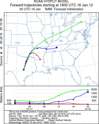
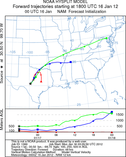
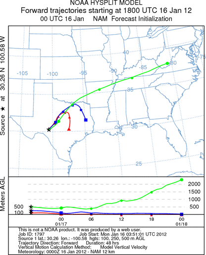
Trajectory weather: Air mass trajectories over the Edwards Plateau will once again move toward the northeast
on southerly winds at moderate to strong levels today then start to decline into the evening. Tomorrow winds will
switch to the north so that the trajectories at the lowest level will move towards the south turning late tonight
into tomorrow morning. The air mass trajectories at the surface reflect the dominant northeasterly pattern today
and then they turn overnight back to the south. Temperatures will be warm today, in the 70s across the entire
region. There is a 20% chance of showers in the northern edge communities northward to Dallas. Lows tonight will
also be warm with the low 40s the minimum across the area. Tomorrow most areas will be in the 50s and 60s with
only the edge communities toying with the 70s. While the ground level winds will be changing, those at upper
elevations will continue to move rapidly towards the upper mid-west and the Great Lakes area.
OUTLOOK: *** Significant Threat today and Significant Threat Tomorrow *** Excellent
conditions for pollen release today and tomorrow with Excellent conditions today and good conditions tomorrow for
entrainment and transport. Skies will be cloudy today and very warm across the region. Winds will be moderate
to strong today then relax tonight as the winds change from the current southwest to a northerly direction. With
the northerly winds cooler temperatures will begin to lower the overall highs. Tomorrow night low temperatures
will be below freezing in all of the communities, except for the communities surrounding the Edwards Plateau.
With a stable southerly flow today and early tonight communities south of the Juniper populations should not see
significant concentrations, but those areas to the north will be heavily impacted. The trajectories show that
the impact will be in north central Texas (Dallas/Fort Worth regional area), across eastern Oklahoma. As soon as
the wind begins to die down and the direction switch to a more northerly direction, any pollen remaining in the
airstream will move southward. At upper elevations across the region, if pollen gets to those heights, we could
see dispersal northeasterly towards the Great Lakes region.
Trajectory Start (s) (shown by *
on map): Austin, TX; Junction, TX; Sonora, TX.
AUSTIN
JUNCTION
SONORA
EDWARDS PLATEAU COMPOSITE
Prepared by: Estelle
Levetin (Faculty of Biological
Science, The
University of Tulsa, 800 S. Tucker Dr., Tulsa, OK 74104) and ) and Peter
K Van de Water (Department of Earth and Environmental Science, California State University Fresno,
2576 East San Ramon Avenue, M/S ST24, Fresno CA 93740-8039). This forecast gives the anticipated future track of
released Mountain Cedar pollen, weather conditions over the region and along the forecast pathway, and an estimated
time of arrival for various metropolitan areas.
Questions: Aerobiology Lab e-mail: pollen@utulsa.edu
Return to Forecasting Home Page