The University of Tulsa
Mountain Cedar Pollen Forecast

Metropolitan Area |
Exposure Risk |
|
Oklahoma City |
Low |
|
Tulsa |
Low |
|
St. Louis MO |
Low |
Date Issued: 17 January 2012
Mountain Cedar Location(s): Arbuckle Mountains, OK
Regional Weather: Tuesday, January 17 TX/OK:
Across the region the weather will be warm to the south and cooling towards the north.. Today across northern
Texas and Oklahoma high temperatures will only get into the 50s and 40s, with central Oklahoma in the low 40s.
Skies will be clear but winds will be strong from the north early, relaxing to moderate levels later in the day.
Further south on the Edwards Plateau and in the surrounding communities the high temperatures will be back into
the 70s with sunny skies and moderate winds from the north and northwest. Tonight clear skies and cold air will
push temperatures into the 20s in Oklahoma and across the Edwards Plateau. In the surrounding communities temperatures
will remain in the upper 30s. Winds will remain moderate to light from the north to northeast across the region.
The cold temperatures tonight will drop tomorrows high by 10 degrees or so, with highs across the southwestern
edge communities in the upper 60s. Across the Plateau and in surrounding communities to the east and north the
high temperature will struggle to get into the mid to low 60s. In the Dallas/Fort Worth area high temperatures
will be in the low 50s and in Oklahoma low 50s and upper 40s. During the day, winds will switch from the colder
northerly direction to a south to southwest wind bringing warmer air back into the region. Winds to the south
will be light to moderate whereas across Oklahoma stronger winds will occur. Northerly winds tomorrow will begin
to switch during the late afternoon into the evening hours. Tomorrow night southerly winds will bring warmer conditions
with most of the temperatures at or above freezing. Across Oklahoma nighttime lows will flirt with the freezing
mark. To the south the edge communities along the southern portion of the Edwards Plateau will remain in the 40s
whereas the rest of the region will fall into the mid 30s. Winds will remain from the south and southwest at
moderate levels, whereas to the north winds will be from the south to southeast at moderate levels.
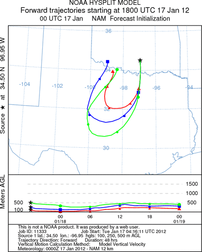
Trajectory weather: Air mass trajectories over southern Oklahoma will move toward the south on northerly
breezes today. Winds will start today as strong with upper speeds as much as 30 miles per hour. The north to
south winds will continue tonight and into tomorrow. Tomorrow winds will reverse and northerly breeze will turn
to southerly winds. As that happens, the trajectories will reverse circling back toward Oklahoma over northern
Texas. The atmosphere appears to be stable and thus pollen released may be entrained, but at heights similar to
the dispersal height. Without lift in the atmosphere much of the pollen will be removed from the atmosphere by
impaction on other surfaces and vegetation. Temperatures across Southern Oklahoma will be only in the 40s today
and low 50s tomorrow. Although the area will be relatively cold today skies will be sunny both today and tomorrow.
OUTLOOK: *** Moderate Threat today and Moderate Threat Tomorrow *** Moderate conditions
for pollen release today but and tomorrow with moderate to poor conditions today and moderate conditions tomorrow
for entrainment and transport. Skies will be clear and sunny today and tomorrow but with thigh temperatures only
in the 40s today and barely getting into the low 50s tomorrow. Winds will be strong from the north today and
early this evening at moderate to light levels. Overnight winds will decline and shift by tomorrow coming out
of the south. With a strong northerly flow communities to the north of the southern Oklahoma tree population will
be relatively free from pollen today and tonight. The trajectories show that any pollen released will impact will
impact areas south towards central Texas (Dallas/Fort Worth regional area). Overnight as the winds switch and
their strength declines the trajectories will switch to a more northerly direction. The density of the atmosphere
from the north will mean that the trajectories will move near the surface where significant impaction can occur.
Cold conditions today will limit pollen release and tomorrow slightly warmer conditions may result in better conditions
for pollination.
Trajectory Start (s) (shown by black
star on map): Davis, OK.
Prepared by: Estelle
Levetin
(Faculty
of Biological Science, The University of Tulsa, 800 S. Tucker Dr., Tulsa, OK 74104) and Peter
K Van de Water
(Department of Earth and Environmental Science, California State University Fresno, 2576 East San Ramon Avenue,
M/S ST24, Fresno CA 93740-8039). This forecast gives the anticipated future track of released Mountain Cedar pollen,
weather conditions over the region and along the forecast pathway, and an estimated time of arrival for various
metropolitan areas.
Questions: Aerobiology Lab e-mail: pollen@utulsa.edu
Return to Forecasting Home Page