The University of Tulsa
Mountain Cedar Pollen Forecast

Metropolitan Area |
Exposure Risk |
|
Oklahoma City |
Moderate |
|
Tulsa |
High |
|
St. Louis MO |
High |
Date Issued: 18 January 2012
Mountain Cedar Location(s): Arbuckle Mountains, OK
Regional Weather: Wednesday, January 18 TX/OK:
Across the region the weather will be seasonal to the south with high temperatures across the Edwards Plateau
and surrounding communities in the 60s today. Towards the east Austin will only reach the upper 50s and areas
further north towards southern Oklahoma will be in the low 50s. Skies will be sunny and winds will be light to
moderate primarily from the south. In the areas surrounding the Edwards Plateau winds will be from the north,
draining off of the Edwards Plateau. Late in the afternoon most areas will begin to switch to a dominant southwesterly
wind pattern. The flow from the southwest will remain overnight with clear to mostly clear skies and temperatures
5 to 10 degrees above freezing. Winds will remain light. Tomorrow sunny skies will once again rule over the region.
Winds will remain from the southwest, but wind speed will increase up to about 15 miles per hour. Temperatures
will rise tomorrow with the low 60s occurring across southern Oklahoma. Over Texas, the surrounding communities
will range from the mid to upper 70s whereas over the Plateau the mid 70s will rule. Tomorrow night with the
southerly breezes partly cloudy skies will build to the north and in the edge communities surrounding the Edwards
Plateau. Urban areas from Austin towards San Antonio will see fog develop after midnight. The area over the Plateau
will have mostly clear skies. Tomorrow nights temperatures will remain warm with upper 30s in southern Oklahoma,
40s and 50s from Dallas southwards circling the eastern edge of the Edwards Plateau, and in the lower 40s on
the Plateau. Winds will remain light from the south, except in the western most regions where the wind will come
out of the southwest.
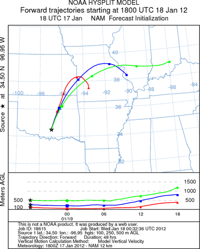
Trajectory weather: Air mass trajectories over the Edwards Plateau will once again move toward the northeast
on southwesterly winds at moderate levels today then decline in strength overnight before building back to todays
strength tomorrow. Temperatures across southern Oklahoma will be in the low 50s today and the low 60s tomorrow.
Conditions will be good today and very good tomorrow for pollen dispersal. The trajectories from southern Oklahoma
move north to northeast on southwesterly winds over Tulsa and are turned towards the east over Missouri. Tomorrow
winds will resume their direction and but with warmer conditions on the ground and in the trees. The air mass trajectories
at the surface reflect the dominant northeasterly pathway on winds from the southwest today, tonight, and tomorrow
into tomorrow night. and Temperatures will be warm today, in the 70s across the entire region.
OUTLOOK: *** Significant Threat today and Significant Threat Tomorrow *** Excellent
conditions for pollen release today and tomorrow with moderate conditions today and tomorrow for entrainment and
transport. Skies will be clear and sunny today and tomorrow with cool conditions today, temperatures in the 50s,
but tomorrow warming into the 60s. Winds will be moderate both days from southwest, overnight winds will decline
but then build again tomorrow after sun-up. With a stable southerly flow communities to the north of Texas and
the southern Oklahoma tree populations will be heavily impacted. The trajectories show their pathway towards the
north, over Tulsa and then into Missouri before they are turned towards the east on a westerly wind. The trajectories
from Texas will follow close behind on the same southwesterly winds towards the border area between Oklahoma and
Texas then towards Missouri as well. Eastern and central Oklahoma are again at risk for a significant amount of
pollen.
Trajectory Start (s) (shown by black
star on map): Davis, OK.
Prepared by: Estelle
Levetin
(Faculty
of Biological Science, The University of Tulsa, 800 S. Tucker Dr., Tulsa, OK 74104) and Peter
K Van de Water
(Department of Earth and Environmental Science, California State University Fresno, 2576 East San Ramon Avenue,
M/S ST24, Fresno CA 93740-8039). This forecast gives the anticipated future track of released Mountain Cedar pollen,
weather conditions over the region and along the forecast pathway, and an estimated time of arrival for various
metropolitan areas.
Questions: Aerobiology Lab e-mail: pollen@utulsa.edu
Return to Forecasting Home Page