
The University of Tulsa
Mountain Cedar Pollen Forecast
Metropolitan Area |
Exposure Risk |
|
Dallas/Fort Worth |
High |
|
Austin |
High |
|
San Antonio |
High |
Date Issued: 18 January 2012
Mountain Cedar Location(s): Edwards Plateau, Texas
Regional Weather: Wednesday, January 18 TX/OK:
Across the region the weather will be seasonal to the south with high temperatures across the Edwards Plateau
and surrounding communities in the 60s today. Towards the east Austin will only reach the upper 50s and areas
further north towards southern Oklahoma will be in the low 50s. Skies will be sunny and winds will be light to
moderate primarily from the south. In the areas surrounding the Edwards Plateau winds will be from the north,
draining off of the Edwards Plateau. Late in the afternoon most areas will begin to switch to a dominant southwesterly
wind pattern. The flow from the southwest will remain overnight with clear to mostly clear skies and temperatures
5 to 10 degrees above freezing. Winds will remain light. Tomorrow sunny skies will once again rule over the region.
Winds will remain from the southwest, but wind speed will increase up to about 15 miles per hour. Temperatures
will rise tomorrow with the low 60s occurring across southern Oklahoma. Over Texas, the surrounding communities
will range from the mid to upper 70s whereas over the Plateau the mid 70s will rule. Tomorrow night with the
southerly breezes partly cloudy skies will build to the north and in the edge communities surrounding the Edwards
Plateau. Urban areas from Austin towards San Antonio will see fog develop after midnight. The area over the Plateau
will have mostly clear skies. Tomorrow nights temperatures will remain warm with upper 30s in southern Oklahoma,
40s and 50s from Dallas southwards circling the eastern edge of the Edwards Plateau, and in the lower 40s on
the Plateau. Winds will remain light from the south, except in the western most regions where the wind will come
out of the southwest.
Trajectory weather: Air mass trajectories over the Edwards Plateau once again will move toward the northeast
on southwest breezes today, tonight, then tomorrow and by tomorrow night they will rotate counterclockwise a bit
coming out of a more due south direction. Winds over the next two days will be light to moderate with 15 miles
per hour be top sustained winds today and tomorrow. Tonight and tomorrow night the winds will decrease and become
light. The atmosphere appears to be buoyant and thus pollen released may be entrained at some height leading
to long-distance travel. Temperatures across Texas will be seasonal today, in the 60s across the region and climb
into the 70s tomorrow. Lows tonight will be in the 30s and low 40s from north to south. Tomorrow night temperatures
will increase by 10 degrees in most areas with 40s and 50s expected. The trajectories show the winds moving
northeast across the state, crossing over eastern Oklahoma and western Arkansas before moving over parts of Missouri.
OUTLOOK: *** Significant Threat today and Significant Threat Tomorrow *** Excellent
conditions for pollen release today and tomorrow with good conditions today and building to Excellent conditions
tomorrow for entrainment and transport. Skies will be sunny and clear today and tomorrow. Winds will be moderate
across the Plateau today then relax tonight. The winds will remain from the southwest direction over the forecast
period. With the southerly winds warm temperatures and a more humid atmosphere will occur. Tomorrow night in
the edge communities after midnight foggy conditions may build as a result. With a stable southwesterly flow today
and tomorrow communities north of the Juniper populations will see significant concentrations. Areas that include
the southern Oklahoma population of trees will be in the pathway of entrained pollen from Texas. The wind trajectories
that pollen transport and deposition will put communities in north Texas, eastern Oklahoma, western Arkansas and
Missouri are at risk for significant concentrations in the atmosphere. Those areas to the south of the Edwards
Plateau will be less impacted by the smaller juniper populations.
Trajectory Start (s) (shown by *
on map): Austin, TX; Junction, TX; Sonora, TX.
AUSTIN
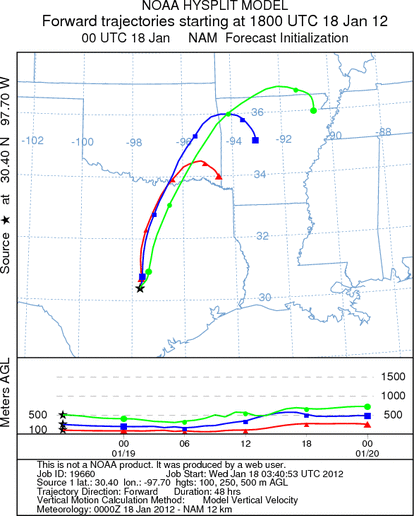
JUNCTION
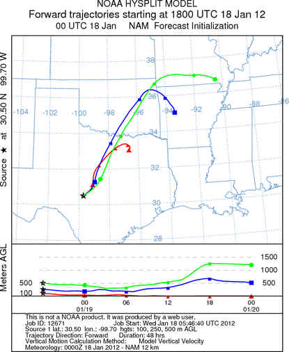
SONORA
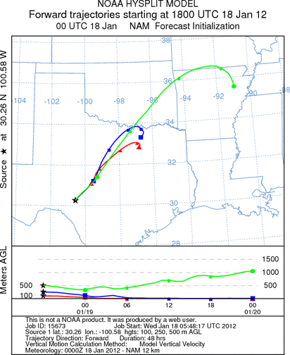
EDWARDS PLATEAU COMPOSITE
Prepared by: Estelle
Levetin (Faculty of Biological
Science, The
University of Tulsa, 800 S. Tucker Dr., Tulsa, OK 74104) and ) and Peter
K Van de Water (Department of Earth and Environmental Science, California State University Fresno,
2576 East San Ramon Avenue, M/S ST24, Fresno CA 93740-8039). This forecast gives the anticipated future track of
released Mountain Cedar pollen, weather conditions over the region and along the forecast pathway, and an estimated
time of arrival for various metropolitan areas.
Questions: Aerobiology Lab e-mail: pollen@utulsa.edu
Return to Forecasting Home Page