
The University of Tulsa
Mountain Cedar Pollen Forecast
Metropolitan Area |
Exposure Risk |
|
Dallas/Fort Worth |
High |
|
Austin |
High |
|
San Antonio |
High |
Date Issued: 19 January 2012
Mountain Cedar Location(s): Edwards Plateau, Texas
Regional Weather: Thursday, January 19 TX/OK:
Across the region the weather will be warm with most areas in the mid to upper 70s. To the north in southern
Oklahoma the temperatures will cool with the high;s in the mid to upper 60s. The skies will be partly cloudy
to the north in Oklahoma then sunny across the rest of Texas. Far to the west this afternoon partly cloudy conditions
will return but will not last long as tonight mostly clear skies will occur across the Edwards Plateau. Today
winds will be from the west to the north and from the southwest across Texas. Winds will be light to moderate,
5 to 15 miles per hour. Tonight temperatures will drop into the mid to low 30s in Oklahoma while in Texas the
northern areas and over the Edwards Plateau low temperatures will be in the 40s. In the surrounding areas low
temperatures will be in the 50s with enough humidity to produce patchy fog in these communities. Winds will remain
from the southwest over most of the areas across Texas. To the north winds will be either light and variable or
light from the east. Tomorrow mixed conditions will result in partly cloudy skies across Oklahoma and across the
Edwards Plateau. On the Plateau the clouds will dissipate towards the afternoon. In the surrounding communities
mostly cloudy conditions will exist with morning fog common. Temperatures tomorrow will be warm. To the north
and in the surrounding communities high temperatures will be in the low to high 70s. Temperatures will increase
towards the south. On the Edwards Plateau high temperatures will reach into the lower 80s. Winds will increase
tomorrow with base winds moderate. In the surrounding communities and north towards the Dallas/Fort Worth regional
area gusts may reach as high as 35 miles per hour. Tomorrow night in Oklahoma temperatures will return into the
20s whereas lows will be much warmer to the south across Texas. Skies will be mostly clear except for over the
urban areas surrounding the Edwards Plateau where partly cloudy conditions will occur. Low temperatures will be
in the upper 30s and lower 40s across the Plateau. In the surrounding communities lows will only fall to the
low 50s. Winds tomorrow night will be moderate from the northwest in central Oklahoma and from the northeast
along the border with Texas. Across Texas winds will remain from the southwest at moderate levels and from the
west over the Edwards Plateau.
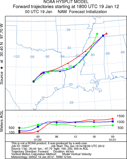
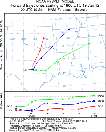
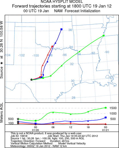
Trajectory weather: Air mass trajectories over the Edwards Plateau once again will move toward the northeast
on southwest breezes today, tonight, tomorrow. Tomorrow night the winds will rotate clockwise for a mostly westerly
flow. Winds over the next two days will be light to moderate with 15 miles per hour be top sustained winds. Tomorrow
afternoon many areas in northern Texas and along the Edwards Plateau it will become gusty with speeds of 25 miles
per hour or more. The atmosphere appears to be buoyant and thus pollen released may be entrained at some height
leading to long-distance travel. Temperatures across Texas will be unseasonably warm today, in the upper 70s
today across the region and climbing into the 80s tomorrow. Lows tonight will be in the upper 30s and low 50s
from north to south. Tomorrow night temperatures will increase by 10 degrees in most areas with 40s and 50s
expected. The trajectories show the winds moving northeast across the state on a continuation of southwesterly
winds. The wind trajectories, crossing over eastern Oklahoma and into western Arkansas.
OUTLOOK: *** Significant Threat today and Significant Threat Tomorrow *** Excellent
conditions for pollen release today and tomorrow with good conditions today and building to Excellent conditions
tomorrow for entrainment and transport. Skies will be sunny and clear today and tomorrow. Winds will be moderate
across the Plateau today then relax tonight. The winds will remain from the southwest direction over the forecast
period. Temperatures will be warm both today and increasingly warm tomorrow. With the southerly winds, warm temperatures,
a more humid atmosphere will occur. Tomorrow night in the edge communities after midnight foggy conditions may
build as a result lasting into tomorrow morning. With a stable southwesterly flow today and tomorrow communities
north of the Juniper populations will see significant concentrations. Areas that include the southern Oklahoma
population of trees will be in the pathway of entrained pollen from Texas. The wind trajectories that pollen transport
and deposition will put communities in north Texas, eastern Oklahoma, western Arkansas and Missouri are at risk
for significant concentrations in the atmosphere. Those areas to the south of the Edwards Plateau will be less
impacted by the smaller juniper populations.
Trajectory Start (s) (shown by *
on map): Austin, TX; Junction, TX; Sonora, TX.
AUSTIN
JUNCTION
SONORA
EDWARDS PLATEAU COMPOSITE
Prepared by: Estelle
Levetin (Faculty of Biological
Science, The
University of Tulsa, 800 S. Tucker Dr., Tulsa, OK 74104) and ) and Peter
K Van de Water (Department of Earth and Environmental Science, California State University Fresno,
2576 East San Ramon Avenue, M/S ST24, Fresno CA 93740-8039). This forecast gives the anticipated future track of
released Mountain Cedar pollen, weather conditions over the region and along the forecast pathway, and an estimated
time of arrival for various metropolitan areas.
Questions: Aerobiology Lab e-mail: pollen@utulsa.edu
Return to Forecasting Home Page