
The University of Tulsa
Mountain Cedar Pollen Forecast
Metropolitan Area |
Exposure Risk |
|
Dallas/Fort Worth |
High |
|
Austin |
High |
|
San Antonio |
High |
Date Issued: 21 January 2012
Mountain Cedar Location(s): Edwards Plateau, Texas
Regional Weather: Saturday/Sunday, January 21/22 TX/OK:
Across the region today temperatures will cool from Fridays very warm conditions. Skies will remain sunny to
the north and mostly sunny across Texas. Winds will be from the north for most of today at light conditions in
Oklahoma and light to moderate winds speeds across Texas. Temperatures in Oklahoma and the border region with
Texas will be in the 40s grading towards the upper 50s in the Dallas/Fort Worth metro area. Further south on
the Edwards Plateau and in the surrounding communitys temperatures will be in the 60s with San Antonio flirting
with 70 degrees. Towards the late afternoon winds will begin to turn coming out of the south in most areas and
out of the east in the edge communities surrounding the Edwards Plateau. Those eastern winds will bring humidity
and after midnight result in fog laying into the edge communities. In Oklahoma and the far reaches of the Edwards
Plateau a more southwesterly flow will take over with winds increasing to moderate levels. Moderate winds will
begin early tomorrow from the west and southwest. Overnight temperatures will be in the upper 30s north of the
Oklahoma/Texas border and 40s to the south, with areas of the western Edwards Plateau in the low 40s and the
other regions milder. Winds will be strong to the north and moderately strong over the rest of the region. Late
in the afternoon winds will begin to turn coming from the northwest then from the north later in the evening.
Tomorrow temperatures will once again be in the high 70s reaching the 80 degree mark around the San Antonio metro
area. Tomorrow night clear and mostly clear conditions will occur with low temperatures in the mid 30s in the
area of the Oklahoma tree population as well as the western Edwards Plateau communities. Low temperatures in the
surrounding communities and north towards Dallas/Fort Worth will be in the low 40s.
Trajectory weather: Air mass trajectories over the Edwards Plateau will initially move to the south and
then turn once again tonight and tomorrow back and flow to the north. The flow to the north will occur tomorrow
during the day but then turn tomorrow night southward once again as northerly winds take over once more. Today
temperatures will cool from Fridays very warm conditions with a 10 to 15 degree drop in most areas associated
with the winds from the north. With such a stretch of warm temperatures tonights lows will be mild with few communities
dropping below 40 degrees. Tomorrow warm temperatures will return as the southerly winds pick up once more. Temperatures
are expected across Texas to be in the 70s with the San Antonio reaching for 80 degrees. Overnight winds will
shift once again coming from the north. Low temperatures tomorrow night will once again be above freezing but
cooler than Saturday with lows in the low 40s and mid to upper 30s
OUTLOOK: *** Significant Threat today and Significant Threat Tomorrow *** Excellent
conditions for pollen release today and tomorrow with excellent conditions today and tomorrow for entrainment and
transport. Skies will be sunny and mostly clear today and tomorrow. Winds will be moderate from the north across
the region. This afternoon the winds will turn from the north and start coming from the south to southwest. On
Sunday the winds will start from the southwest then switch back to a flow from the north. With cooler temperatures
than Friday and a stable northerly flow today communities to the south of the Juniper populations will see significant
concentrations. Winds will turn this evening potentially bringing entrained pollen back towards the north. In
Texas this would bring late concentrations across the Edwards Plateau towards the Dallas/Fort Worth regional area.
Pollen from the southern Oklahoma population of trees will move south on the northerly winds then turn over northern
Texas as the wind switches. Sunday the southerly winds start to swing around towards the west and eventually coming
out of the north again tomorrow night. Wind trajectories will transport and deposit pollen across central Texas
then into Oklahoma resulting in a high risk for significant concentrations in the atmosphere over the entire region.
There will be excellent conditions for pollination with the warm temperatures and winds in the moderate to gusty
range conditions should provide ample opportunities for entrainment and travel.
Trajectory Start (s) (shown by *
on map): Austin, TX; Junction, TX; Sonora, TX.
AUSTIN
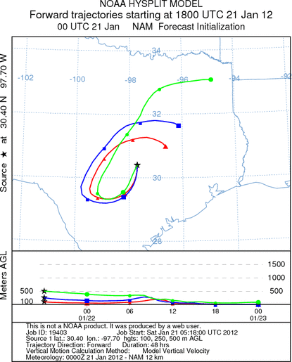
JUNCTION
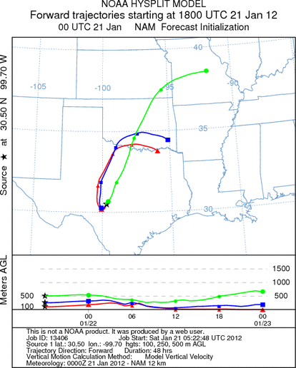
SONORA
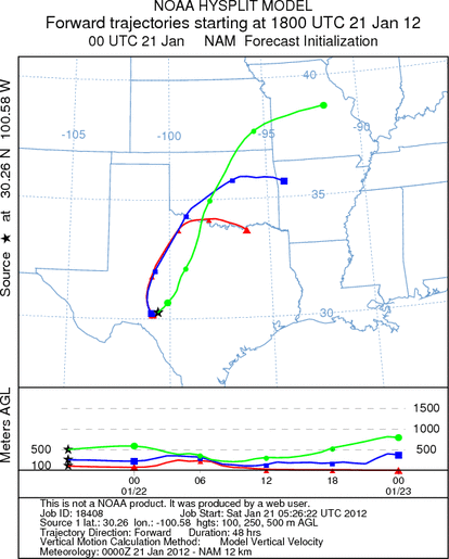
EDWARDS PLATEAU COMPOSITE
Prepared by: Estelle
Levetin (Faculty of Biological
Science, The
University of Tulsa, 800 S. Tucker Dr., Tulsa, OK 74104) and ) and Peter
K Van de Water (Department of Earth and Environmental Science, California State University Fresno,
2576 East San Ramon Avenue, M/S ST24, Fresno CA 93740-8039). This forecast gives the anticipated future track of
released Mountain Cedar pollen, weather conditions over the region and along the forecast pathway, and an estimated
time of arrival for various metropolitan areas.
Questions: Aerobiology Lab e-mail: pollen@utulsa.edu
Return to Forecasting Home Page