
The University of Tulsa
Mountain Cedar Pollen Forecast
Metropolitan Area |
Exposure Risk |
|
Dallas/Fort Worth |
High |
|
Austin |
High |
|
San Antonio |
High |
Date Issued: 23 January 2012
Mountain Cedar Location(s): Edwards Plateau, Texas
Regional Weather: Monday, January 23 TX/OK:
Across the region today may be the last day of the stretch of sunny skies and warm to very warm conditions. Skies
today will be mostly sunny across Texas with partly cloudy skies across Oklahoma. Temperatures are expected to
climb into the 70s south of Dallas/Fort Worth across the Edwards Plateau and throughout the edge communities.
To the north, the juniper trees of southern Oklahoma should be in the low 60s today. Winds will be light and
variable to the north and southward into northern Texas. Winds will be from the southwest over the plateau and
build towards 10 to 15 miles per hour during the day. Tonight clouds begin to move in with partly cloudy conditions
expected region wide. Temperatures will remain warm with the edge communities only falling into the lower 50s,
the Plateau being in the mid to low 40s, and areas in northern Texas and Oklahoma dropping into the upper 30s.
Winds will be from the east and southeast in most areas. The return of southerly winds will bring a 20% chance
of showers to the edge communities tonight after midnight. Tomorrow Oklahoma and north Texas will see partly cloudy
to partly sunny skies. From Dallas/Fort Worth southward cloudy skies will prevail and there is a 60% top 70% chance
of rain in the edge communities of the Edwards Plateau. On the Plateau that chance of showers drops to 40% to
50% today. High temperatures will remain in the 60s in most places with the southern edge communities even flirting
with 70 degrees. In the morning the greatest chance is for showers, whereas later in the day thunderstorms and
showers will continue to develop. Winds will be moderate from the southeast at 10 to 15 miles per hour. Tuesday
night Cloudy conditions and rain will occur across the region. Low temperatures will remain warm with most areas
in the 40s upwards to the 60s in San Antonio and 50s in Austin. Winds will remain from the east off of the
Plateau region, where winds will be from the north and northeast. Winds will remain moderate at levels from 10
to 15 miles per hour.
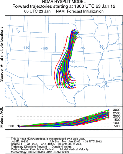
Trajectory weather: Air mass trajectories over the Edwards Plateau move almost due north on southerly winds
today. Other areas have light winds from the east after starting the day from the northeast, but over the Edwards
Plateau a moderate southwesterly flow will push any pollen entrained in the atmosphere northwards across Oklahoma
and into Nebraska. Today temperatures will be in the lower 70s across the Plateau with low to mid 70s in the
surrounding communities. Skies will be mostly sunny heading towards partly cloudy conditions into the late afternoon
and evening. Winds will switch overnight, coming from the east and then from the southeast. The southeasterly
winds will bring warm humid air resulting in partly cloudy skies and an increasing chance of showers into Tuesday.
High tomorrow will cool into the 60s and there will be a significant chance of showers in the morning and then
developing again in the afternoon with thunderstorms. Winds will be moderate from the southeast. Tomorrow night
cloudy conditions and a significant chance of rain across the region is forecast. Low temperatures will be mild
and during the night time hours winds will swing around coming from the east except for a northeasterly wind over
the western Plateau.
OUTLOOK: ***Significant Threat today and Poor Threat Tomorrow
*** Excellent conditions for pollen release today with excellent conditions for entrainment and transport.
Tomorrow significant rain is expected which should severely restrict and entrainment and travel . Skies will
be mostly sunny clear today but partly cloudy skies will build tonight. Winds will be light from the southwest
across the Edwards Plateau region. This evening skies will become partly cloudy and winds will switch coming out
of the east to southeast. With the wind shift, humidity will rise and in many areas of the edge communities the
chance of rain will begin to increase. Tuesday will start with the chance of showers which will increase during
the day and into Tuesday night. With temperatures still in the 70s today and a moderate southwesterly wind blowing
northward communities north of the Juniper populations will see significant concentrations. With winds coming
in from the east the Plateau winds, which should have pollen entrained will ride over the top and continue to push
towards Oklahoma going into this evening. Tomorrow, the winds will have brought in enough warm humid air that
the chance of rain increases significantly and the chance of showers in the morning and afternoon increases significantly.
Tomorrow night a significant chance of rain will exist across Texas. As the humidity and showers move into the
area, the act of precipitation will cleanse the atmosphere from its pollen load.
Trajectory Start (s) (shown by *
on map): Austin, TX; Junction, TX; Sonora, TX.
AUSTIN
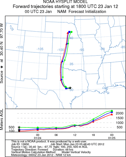
JUNCTION
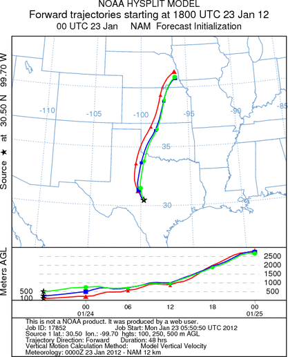
SONORA
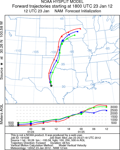
EDWARDS PLATEAU COMPOSITE
Prepared by: Estelle
Levetin (Faculty of Biological
Science, The
University of Tulsa, 800 S. Tucker Dr., Tulsa, OK 74104) and ) and Peter
K Van de Water (Department of Earth and Environmental Science, California State University Fresno,
2576 East San Ramon Avenue, M/S ST24, Fresno CA 93740-8039). This forecast gives the anticipated future track of
released Mountain Cedar pollen, weather conditions over the region and along the forecast pathway, and an estimated
time of arrival for various metropolitan areas.
Questions: Aerobiology Lab e-mail: pollen@utulsa.edu
Return to Forecasting Home Page