The University of Tulsa
Mountain Cedar Pollen Forecast

Metropolitan Area |
Exposure Risk |
|
Oklahoma City |
Low |
|
Tulsa |
Low |
|
St. Louis MO |
Low |
Date Issued: 26 January 2012
Mountain Cedar Location(s): Arbuckle Mountains, OK
Regional Weather: Thursday, January 26 TX/OK:
Across the region today there will be remnant moisture from yesterdays rain and showers. Early today most skies
will be partly cloudy but will then begin to clear leaving most communities in sunny weather this afternoon. The
area from southern Oklahoma southwards towards Austin will remain within a chance of showers in the morning hours.
These areas will also begin to clear in the afternoon. High temperatures will climb right back to levels that
have recently been common. Highs will be in the 50s to the north and in the 60s across the Plateau and in the
southern edge communities around San Antonio. Winds will be from the north on the Edwards Plateau and to the far
north in Oklahoma at moderate levels. Between the border country and the surrounding communities of Austin winds
will be from the northwest at moderate to strong conditions. Many of these areas will see gusts as high as 30
miles per hour. Tonight skies will be clear over most of the region. Low temperatures overnight will be in the
mid 30s toward the north in Oklahoma and around the Dallas/Fort Worth area. Further south and west the Edwards
Plateau will also be in the low 30s tonight. The surrounding edge communities will drop to 40 with slightly warmer
conditions in the urban areas. Winds will be out of the north across the area at light to moderate levels. Tomorrow
skies will be sunny region wide. In southern Oklahoma, morning patchy fog is expected. High temperatures tomorrow
will be in the 60s region wide. The north will be in the low 60s whereas over the plateau and in the surrounding
areas highs will be in the mid- to upper-60s. Winds will start from the north and northwest but eventually switch,
coming out of the south in the afternoon. The Plateau will have a southwest wind most of the day. Tomorrow night
mostly clear conditions to the south will be common whereas more partly cloudy skies will occur to the north.
Low temperatures will return to the same levels as tonight, 30s on the Plateau and low 40s in the surrounding
communities. Winds will begin from the south and southeast then switch coming from the north. Winds will be from
the west to northwest and north over the Plateau. Overall most of the trajectories will generally swirl over central
Texas for the next couple of days.
Trajectory weather: Air mass trajectories over the Edwards Plateau move south to southeast today on northerly
breezes that will be at moderate to strong strength. In the areas of central Texas from Austin to the border region
there will be a slight chance of showers continuing into the morning hours. The remainder of the area will be
partly sunny in the morning. In southern Oklahoma partly cloudy skies will remain from the past two days of wet
weather. All areas will begin to clear during the day becoming partly sunny where it had been cloudy and being
fully sunny in the other areas of the region. Winds will be from the north to northwest today and tonight at moderate
levels moving any trajectory to the south and southeast. Tomorrow the region will be sunny with temperatures climbing
into the low to upper 60s. The predominant northerly winds will turn during the day coming from the south. Tomorrow
night the winds will turn once more coming from the north. This seesaw of wind directions will cause the trajectories
to travel southward the move abruptly back towards the north
OUTLOOK: *** Low Threat today and Moderate Threat Tomorrow
*** Poor conditions for pollen release today and moderate conditions tomorrow with poor conditions for entrainment
and transport today but better conditions tomorrow. Skies will be cloudy today. Rain, thunderstorms, and showers
will still be possible from Austin north to the Oklahoma border. During the day most of the skies will clear and
temperatures will bounce back into the upper 50s in the border area. Signs of pollination are beginning to slow
down with lower levels detected. In addition, pollen types that are more spring like are beginning to be recorded
in the pollen counts. After the last days of rain it will be interesting to see the level of pollen concentrations
of juniper pollen that returns to the atmosphere. Tomorrow conditions will improve with warmer dryer conditions.
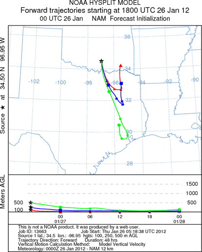
Trajectory Start (s) (shown by black
star on map): Davis, OK.
Prepared by: Estelle
Levetin
(Faculty
of Biological Science, The University of Tulsa, 800 S. Tucker Dr., Tulsa, OK 74104) and Peter
K Van de Water
(Department of Earth and Environmental Science, California State University Fresno, 2576 East San Ramon Avenue,
M/S ST24, Fresno CA 93740-8039). This forecast gives the anticipated future track of released Mountain Cedar pollen,
weather conditions over the region and along the forecast pathway, and an estimated time of arrival for various
metropolitan areas.
Questions: Aerobiology Lab e-mail: pollen@utulsa.edu
Return to Forecasting Home Page