The University of Tulsa
Mountain Cedar Pollen Forecast

Metropolitan Area |
Exposure Risk |
|
Oklahoma City |
Low |
|
Tulsa |
Low |
|
St. Louis MO |
Low |
Date Issued: 28 January 2012
Mountain Cedar Location(s): Arbuckle Mountains, OK
Regional Weather: Saturday, January 28/ Sunday, January
29 TX/OK: Across the region today and tomorrow conditions will be cool with todays highs in the 50s
in most area and tomorrow temperatures will be in the upper 50s to low 60s. In Oklahoma, partly cloudy skies
will occur today, tonight and tomorrow. Winds will be from the northwest today and tonight at light levels. Tomorrow
winds will be shifting, coming out of the southwest. Winds will be light, up to 10 miles per hour tomorrow and
then back to light and variable conditions tomorrow night. Across Texas today, the northern portion will be mostly
sunny to sunny, clearing even more tomorrow. Partly cloudy conditions will occur across the Edwards Plateau today
but clear in the afternoon into tomorrow and tomorrow night. Temperatures will be in the mid to upper 50s today
across Texas with those traditionally warmer communities, such as San Antonio, getting into the low 60s. Winds
will be from the north to northeast. Between the Oklahoma border and the northern Edwards Plateau as well as the
surrounding edge communities, moderate winds may occur. The winds may be gusty at times. On the Edwards Plateau
moderate winds from the northeast will occur this morning then begin to relax towards the evening. Overnight light
winds will return to the region with the Plateau winds moving from the south to southeast and the predominant northerly
winds continuing in the surrounding communities towards the Dallas/Fort Worth area. Low temperatures overnight
will be in the upper 20s across Oklahoma and over the Edwards Plateau. I other areas the lows will be near freezing
in most areas including Austin and San Antonio. Tomorrow sunny skies will predominate across Texas. Temperatures
will rise by 5 degrees from today with most readings in the upper 50s to low 60s. Winds have switch coming from
the south at light levels, except in the communities surrounding the Edwards Plateau where a northerly direction
in the winds will be maintained. Winds will be generally light across the entire region. Tomorrow night temperatures
will cool into the 30s and low 40s but above freezing across the region. Winds will be maintained at light levels
from the south.
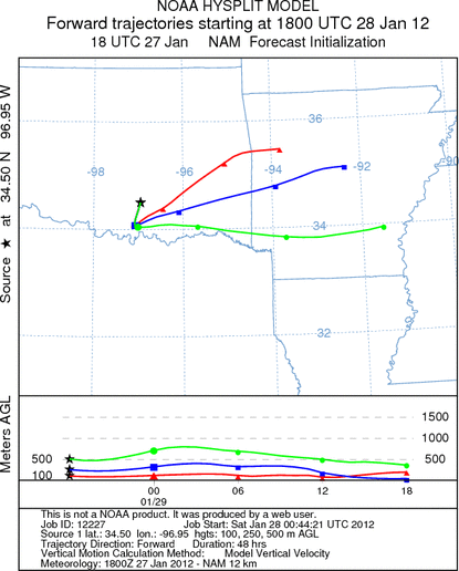
Trajectory weather: Air mass trajectories over southern Oklahoma will move towards the south on light northerly
winds. At ground level the winds will be relatively stable, however above at both 250 and 500 meters the air will
be much more buoyant. The winds will be light as well as light and variable over the forecast period. Beginning
tonight the winds will begin to swing from the north to the west and southwest. As that occurs, the trajectories
from southern Oklahoma will be moved towards the north and east. Temperatures will be cool with highs in the upper
40s today limiting pollen release. Tomorrow temperatures will warm into the upper 50s and low 60s. Tonights
temperatures will be in the upper 20s tonight then warm with lows in the mid to upper 30s.
OUTLOOK: *** Poor Threat today and Moderate Threat Tomorrow
*** Poor conditions for pollen release today and moderate conditions tomorrow with poor conditions for
entrainment and transport today and moderate conditions tomorrow. Skies will partly cloudy today and tomorrow
with cold temperatures across the region today. Tomorrow temperatures will return to the upper 50s and low 60s.
Today the air is buoyant at the upper elevations but on the ground light and variable along with light winds will
predominate. Today the conditions for pollen release area poor. Tomorrow temperatures will warm to conditions
that are better for pollen release. Any pollen that is left to be released should have a good chance to do it.
Across the region the last week has shown the appearance of pollen types that are associated with spring blooming
plants. This usually is a strong signal that the Juniperus pollen season is ending. However, this is at least
a full week if not two ahead of schedule.
Trajectory Start (s) (shown by black
star on map): Davis, OK.
Prepared by: Estelle
Levetin
(Faculty
of Biological Science, The University of Tulsa, 800 S. Tucker Dr., Tulsa, OK 74104) and Peter
K Van de Water
(Department of Earth and Environmental Science, California State University Fresno, 2576 East San Ramon Avenue,
M/S ST24, Fresno CA 93740-8039). This forecast gives the anticipated future track of released Mountain Cedar pollen,
weather conditions over the region and along the forecast pathway, and an estimated time of arrival for various
metropolitan areas.
Questions: Aerobiology Lab e-mail: pollen@utulsa.edu
Return to Forecasting Home Page