The University of Tulsa
Mountain Cedar Pollen Forecast

Metropolitan Area |
Exposure Risk |
|
Oklahoma City |
High |
|
Tulsa |
High |
|
St. Louis MO |
Low |
Date Issued: 30 January 2012
Mountain Cedar Location(s): Arbuckle Mountains, OK
Regional Weather: Monday, January 30 TX/OK:
Across the region today and tomorrow there will be moisture in the air brought by strong gusty winds from the
south. Partly cloudy to cloudy skies will be present today across the region except in the Dallas/Fort Worth area
where mostly sunny skies will develop during the day. Temperatures will be warming with almost all of the high
temperatures in the mid to upper 60s. With the warmer conditions and higher humidity there will be a slight chance
of showers, 20%, in and around the San Antonio area. Winds across the region today will be moderate, 10 to 20
miles per hour. This afternoon wind speeds will increase with gusty conditions between 25 and 30 mile per hour
to the north and on the Edwards Plateau. The surrounding edge communities will maintain moderate winds. Tonight
cloudy conditions will build from the south with mostly cloudy from Dallas/Fort Worth north into southern Oklahoma.
There will be a 20% chance of light rain and fog in the edge communities from Austin to San Antonio. Overnight
low temperatures will be very mild remaining in the 50 degree range. The Plateau will be in the low 50s, whereas
the rest of the region will be in the mid to upper 50s. Winds will relax overnight, remain from the south but
only be light to moderate in strength, 5 to 15 miles per hour. Tomorrow the region will begin the day with mostly
cloudy to cloudy skies. In the edge communities there is a chance of continuing light rain in the morning. The
rain, <20% chance, will dissipate leaving partly sunny skies in the afternoon. Temperatures across Texas and
the southern border region of Oklahoma will be in the mid 70s. Winds will remain from the south at moderate conditions.
As will happen today, wind speeds will increase, coming from the south, during the afternoon with some gusts as
strong as 25 miles per hour. Tomorrow night partly cloudy to mostly cloudy conditions will exist across Texas.
Low temperatures will be in the lower to mid 40s over the Edwards Plateau, and in the 50s to the north and 60s
in the edge communities. Winds will remain from the south and light to moderate levels. In southern Oklahoma
winds will shift, coming from the north. The northerly flow will drop temperatures into the upper 30s and lower
40s overnight.
Trajectory weather: Air mass trajectories over the Southern Oklahoma move due north on southerly winds.
The winds will start light to moderate, but increase to gusty conditions into the afternoon. Temperatures will
be in the 60s across the region. Low temperatures will be mild in the low 50s. Winds will remain from the south
at moderate levels. Tomorrow most of the region will be partly cloudy but temperatures will be in the low 70s
in the Armore Mountains where the population grows. Winds will remain from the south at moderate levels and gusty
conditions in the afternoon. Tomorrow night some cooling will occur as the winds in southern Oklahoma switch,
coming from the north. The colder northerly winds will drop the low temperatures tomorrow night into the low 40s
with Oklahoma City only in the upper 30s.
OUTLOOK: *** High Threat today and High Threat Tomorrow *** Good conditions for
pollen release today and tomorrow with moderate conditions for entrainment and transport today and tomorrow. Skies
will be partly cloudy today and tomorrow but with warm temperatures and moderate, gusty winds across the region
today. Today temperatures are expected in the upper 60s, with tomorrows temperatures in the lower 70s. Today
the air is stable and thus entrainment and travel occur in conditions that often result in a lot of impaction along
the trajectory pathway. The weather conditions are good for release and some travel downwind. In addition, the
trajectories from Texas will cross into Oklahoma and travel due north. Any pollen that is left to be released
should have a good chance to do it in the next two days. Across the region the last week has shown the appearance
of pollen types that are associated with spring blooming plants. This usually is a strong signal that the Juniperus
pollen season is ending. However, this is at least a full week if not two ahead of schedule.
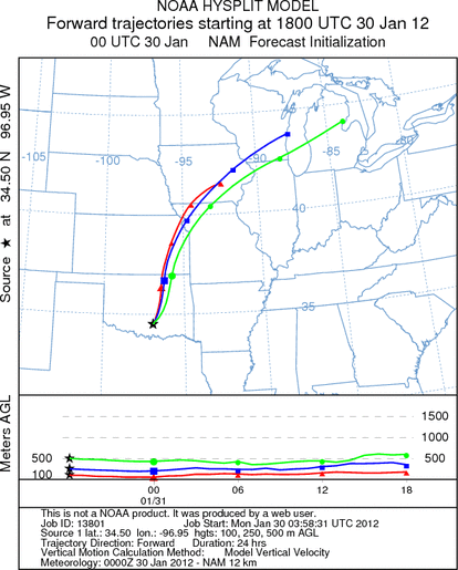
Trajectory Start (s) (shown by black
star on map): Davis, OK.
Prepared by: Estelle
Levetin
(Faculty
of Biological Science, The University of Tulsa, 800 S. Tucker Dr., Tulsa, OK 74104) and Peter
K Van de Water
(Department of Earth and Environmental Science, California State University Fresno, 2576 East San Ramon Avenue,
M/S ST24, Fresno CA 93740-8039). This forecast gives the anticipated future track of released Mountain Cedar pollen,
weather conditions over the region and along the forecast pathway, and an estimated time of arrival for various
metropolitan areas.
Questions: Aerobiology Lab e-mail: pollen@utulsa.edu
Return to Forecasting Home Page