
The University of Tulsa
Mountain Cedar Pollen Forecast
Metropolitan Area |
Exposure Risk |
|
Dallas/Fort Worth |
Low |
|
Austin |
Low |
|
San Antonio |
Low |
Date Issued: 2 January 2013
Mountain Cedar Location(s): Edwards Plateau, Texas
Regional Weather: Wednesday, January 2 TX/OK:
Across the region the weather continues to be seasonally cool with high temperatures to the north climbing into
the low to mid 40s and across Texas temperatures today will also be in the 40s in most regions. The western
most portion of the Edwards Plateau, and south towards San Antonio will flirt with a high of 50 degrees today.
Winds will be lite from the north to the northeast for the next two days. Skies will remain partly cloudy to
the north and mostly cloudy over the Edwards Plateau. Tonight most areas, except for the edge communities along
the southern and southeastern areas of the Edwards Plateau, will fall into the mid 20s. The surrounding communities
will remain in the 30s. Winds will maintain a flow from the north to northeasterly direction at lite levels.
Tomorrow mostly sunny conditions will occur from Oklahoma into the northern portion of Texas. Over the Edwards
Plateau and in the edge communities, skies will be mostly cloudy to cloudy throughout the day. The western most
region of the forecast area will begin to see the chance of snow and rain beginning on Thursday afternoon. Winds
will flow from the north and northeast but will gain in strength approaching moderate conditions. Thursday night
in south central Texas and on the Edwards Plateau and in the surrounding communities the chance of precipitation
builds. The Plateau communities can expect precipitation in the form of snow and rain, whereas edge communities
will mostly see rain. Temperatures will vary from the upper 20s on the Edwards Plateau to the mid 30s in the
edge communities. Winds will remain from the north to northeast at moderate levels.
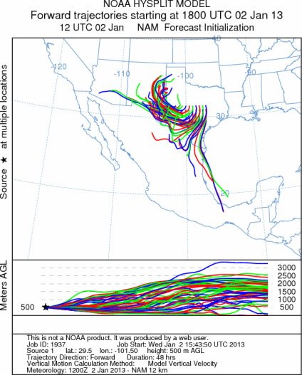
Trajectory weather: Air mass trajectories over the Edwards Plateau move southward today and then move towards
the southwest, before tuning and moving towards the southeastern portion of New Mexico. The atmosphere will be
buoyant as moisture continues to stream in from the southwest and interacts with the dominant cold conditions from
the north and northeast. Communities across the Edwards Plateau and southward will be affected by any pollen released
today, however relatively cold conditions and recent rains should stall significant pollen release. Pollen release
today and tomorrow will have about the same chance with temperatures in the 40s in most areas. The surrounding
communities will struggle to get into the low 50s. Conditions over the past 3 to 4 days have brought precipitation
and cold conditions thus the trees may be sluggish in releasing any pollen today. However, local release is always
possible and may affect allergy sufferers. Tonight cold conditions will return and tomorrow conditions will continue
to be nearly the same although there is an increasing chance of precipitation beginning tomorrow afternoon to the
west and spreading east into the evening hours. Winds will be lite and be maintained with flow from the north
and northeast.
OUTLOOK: *** Low to Moderate Threat today and Low
Threat tomorrow *** Cool to moderate temperatures across the region for pollen release today and tomorrow.
Temperatures today will struggle to get into the upper 40s and 50 at the southernmost area of the tree population.
Temperatures will remain cool with most areas in the 40s both today and tomorrow. The chance of precipitation
is not in the forecast today but begins to increase tomorrow to the west. The atmosphere will be buoyant as moist
air streams in from the southwest and interacts with the dominant north to northeasterly flow. For these reasons
there will be good conditions for entrainment and travel at times but pollen release should be marginal today and
tomorrow. Once warm conditions return pollen will begin to flow once again. We are approaching the heart of the
historic pollination season. We continue to have patients contacting the modeling team to report strong allergy
symptoms. Today and tomorrow will have low pollen levels confined to south Texas if any pollen becomes airborne.
It should continue to provide a nice break for allergy sufferers, but once again as the region dries out the remaining
pollination season will return.
Trajectory Start (s) (shown by *
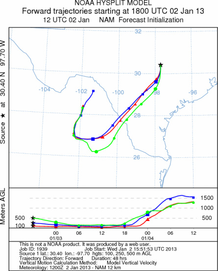
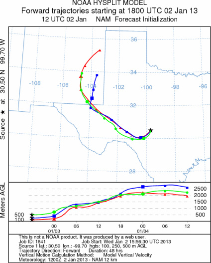
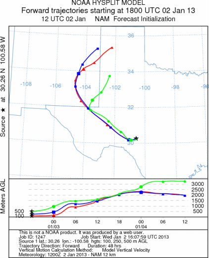
on map): Austin, TX; Junction, TX; Sonora, TX.
AUSTIN
JUNCTION
SONORA
EDWARDS PLATEAU COMPOSITE
Prepared by: Estelle
Levetin (Faculty of Biological
Science, The
University of Tulsa, 800 S. Tucker Dr., Tulsa, OK 74104) and ) and Peter
K Van de Water (Department of Earth and Environmental Science, California State University Fresno,
2576 East San Ramon Avenue, M/S ST24, Fresno CA 93740-8039). This forecast gives the anticipated future track of
released Mountain Cedar pollen, weather conditions over the region and along the forecast pathway, and an estimated
time of arrival for various metropolitan areas.
Questions: Aerobiology Lab e-mail: pollen@utulsa.edu
Return to Forecasting Home Page