
The University of Tulsa
Mountain Cedar Pollen Forecast
Metropolitan Area |
Exposure Risk |
|
Dallas/Fort Worth |
Low |
|
Austin |
Moderate |
|
San Antonio |
Moderate |
Date Issued: 5 January 2013
Mountain Cedar Location(s): Edwards Plateau, Texas
Regional Weather: Saturday, January 5 TX/OK:
Across the region the weather will be warming and clearing out after the past week of cold and rainy conditions.
The last chance of precipitation will be leaving the areas surrounding the Edwards Plateau this morning (20% chance
in the AM) and warmer temperatures are on their way this afternoon and into tomorrow. This morning skies will
start as partly cloudy in most areas but will clear quickly as partly sunny to sunny conditions spread across the
region. High temperatures across the area will regain the 50s. The Dallas/Fort Worth metro region will be in
the mid 50s this afternoon, whereas the communities surrounding the Edwards Plateau will just reach 50 degrees.
On the Edwards Plateau itself, high temperatures today will just get to 50 degrees in most areas. Oklahoma City
will stay in the mid 40s but the 50 degree mark will occur in areas bordering north Texas, such as the Arbuckle
Mountains. Winds will be from the south and southwest at lite to moderate in all locations, except on the Edwards
Plateau where a predominantly west to northwest wind direction will blow at lite to moderate wind speeds. Tonight
skies will remain monstly clear to clear with temperatures to the north and across the Plateau in the mid to upper
20s. The area from Dallas/Fort Worth southward along the Edwards Plateau edge will remain in the low to mid 30s.
Winds will remain lite to moderate but the flow across the region will be coming from the west and northwest.
Tomorrow, improving conditions will see sunny skies and temperatures wil be firmly in the 50s. The southernmost
communities bordering the Edwards Plateau will flirt with the 60 degree mark. Winds will begin to build as they
switch from the west and northwest flow of the past evening and come from a more northeasterly direction. In the
edge communities winds will become moderate in strength. Tomorrow night mostly clear to clear conditions return
across the region with low temperatures in the mid to low 30s in the edge communities and returning into the 20s
north in Oklahoma and on the Edwards Plateau itself.
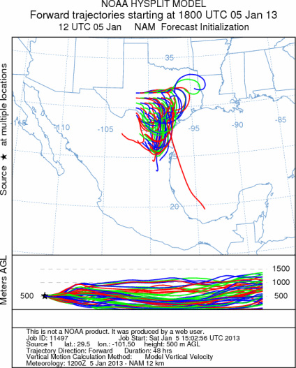
Trajectory weather: Air mass trajectories over the Edwards Plateau move towards the east and southeast on
northwesterly winds, but will swirl over this area during the forecast period. Any Pollen that is entrained will
move southward impacting communities primarily to the south of the tree population. The air will be moderately
buoyant as warming and drying begins across the Edwards Plateau. Over the past few days most of the Edwards Plateau
has seen either frozen precipitation or rain. Those conditions have not moved out of the area and the trees and
ground will begin to dry. As the region warms the anticipated release of pollen in large amounts should resume
and thus winds moving through the area will have a very good chance of picking up and entraining pollen in the
air stream. The Arbuckle Mountains in southern Oklahoma will remain in the upper 40s but with clear skies. This
area too, will begin to dry out and we should see the initial movement of pollen from this area either today or
tomorrow. Local releases are always possible and may affect allergy sufferers directly if they are in close contact
with individual trees, and or live in areas where the tree populations occur. Downwind transport today and tomorrow
will move pollen south of the Edwards Plateau into southernmost Texas and Mexico.
OUTLOOK: *** Moderate Threat today and High threat Tomorrow
*** Warming temperatures across the region for pollen release today and tomorrow with conditions in
the 50s and clear skies. Temperatures today will move into the 50s on the Edwards Plateau and in the surrounding
edge communities. The chance of precipitation has left the area and warmer conditions are forecast. The atmosphere
will be moderately buoyant and winds will move the trajectories towards the southernmost region of the state.
Pollen entrained within the air mass will move towards Loredo and Corpus Christi over the next 24 to 48 hours.
For these reasons there will be good conditions for entrainment and travel at times and pollen release should
be building today and tomorrow as the area dries out. The trees will start slow as the region needs to both warm
and dryout, therefore pollen levels will build over the forecast period. We are approaching the heart of the historic
pollination season and the long-term forecast suggests a string of warmer days on the horizon. Today there will
be low pollen levels in the atmosphere compared to tomorrow when pollen will be on the rise. Conditions have provided
a nice break for allergy sufferers, but as the region dries out the pollination season returns.
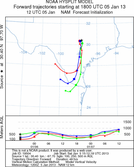
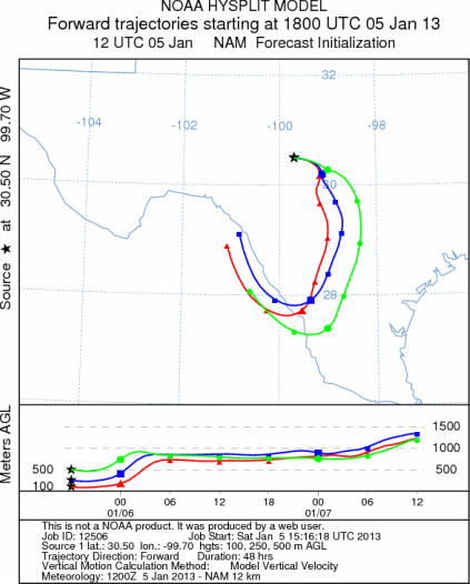
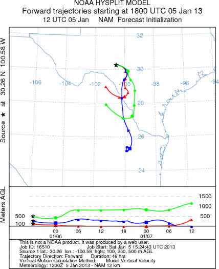
Trajectory Start (s) (shown by *
on map): Austin, TX; Junction, TX; Sonora, TX.
AUSTIN
JUNCTION
SONORA
EDWARDS PLATEAU COMPOSITE
Prepared by: Estelle
Levetin (Faculty of Biological
Science, The
University of Tulsa, 800 S. Tucker Dr., Tulsa, OK 74104) and ) and Peter
K Van de Water (Department of Earth and Environmental Science, California State University Fresno,
2576 East San Ramon Avenue, M/S ST24, Fresno CA 93740-8039). This forecast gives the anticipated future track of
released Mountain Cedar pollen, weather conditions over the region and along the forecast pathway, and an estimated
time of arrival for various metropolitan areas.
Questions: Aerobiology Lab e-mail: pollen@utulsa.edu
Return to Forecasting Home Page