
The University of Tulsa
Mountain Cedar Pollen Forecast
Metropolitan Area |
Exposure Risk |
|
Dallas/Fort Worth |
Low |
|
Austin |
Moderate |
|
San Antonio |
Moderate |
Date Issued: 6 January 2013
Mountain Cedar Location(s): Edwards Plateau, Texas
Regional Weather: Sunday, January 6 TX/OK: Across
the region the weather will be warming and clearing today with clear sunny skies today and tonight. Late tonight
clouds will begin to build once again for tomorrow, then tomorrow night rain will build over Texas. Winds today
will be from the north at moderate conditions across Oklahoma and moderate from the northeast across Texas. High
temperatures in Oklahoma will be in the 40s and 50s. Across Texas the edge communities will reach into the upper
50s and low 60s. On the Plateau, high temperatures will be in the mid 50s. Tonight low temperatures will drop
into the seasonal mid 20s in most areas to the north and across the Edwards Plateau. In areas from the Dallas/Fort
Worth area southward to the edge communities the low temperatures will remain in the 30s. Winds will be lite
from the northeast in most areas. The far western communities on the Edwards Plateau will see more moderate wind
speeds. Tomorrow partly cloudy skies will build to be mostly cloudy by mid-day. High temperatures will be in
the mid 50s to the north across Oklahoma, and in the mid to upper 50s across Texas. The communities in and around
the Edwards Plateau will be warmer than the communities to the west. Winds will be from the east in east Texas
and from the south-southeast across the Edwards Plateau and in north Texas into Oklahoma. Tomorrow night, cloudy
conditions will remain with moisture moving into Texas. There will a chance of rain tomorrow night from Dallas/Fort
Worth southward across the Edwards Plateau. Low temperatures will remain in the 40s across the region and east
to southeasterly winds will move across the region at moderate levels.
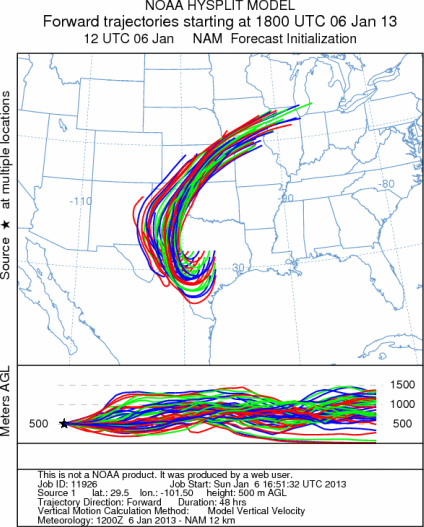
Trajectory weather: Air mass trajectories over the Edwards Plateau move southward on the northeasterly winds
today into tonight. Winds will be lite across the area. Tonight the winds will begin to shift come from the northeast
and then tomorrow the east and southeast. The trajectories will initially flow southward and then loop towards
the north over southeast (Big Bend Country) then back north across the Panhandle of Texas and Oklahoma. The winds
will be buoyant as warmer conditions occur across the region. Moist conditions have not moved out of the area
and the trees and ground drying. As the region warms the anticipated release of pollen in large amounts should
resume and thus winds moving through the area will have a very good chance of picking up and entraining pollen
in the air stream. The Arbuckle Mountains in southern Oklahoma will remain today in the upper 40s with clear
skies, then warm into the 50s tomorrow but with mostly cloudy skies. This area too, will begin to warm and dry
out. With warmer conditions we should see the initial movement of pollen from this area either today or tomorrow.
Local releases are always possible and may affect allergy sufferers directly if they are in close contact with
individual trees, and or live in areas where the tree populations occur. Downwind transport today and tomorrow
will move pollen south of the Edwards Plateau into southernmost Texas and Mexico.
OUTLOOK: *** High Threat today and High Threat tomorrow *** Warming temperatures
across the region for pollen release today and tomorrow. Conditions will be in the 50s and clear skies today and
increasing clouds but still warm tomorrow. Temperatures today will move into the 50s on the Edwards Plateau and
in the surrounding edge communities. The chance of precipitation has left the area and warmer conditions are forecast.
The atmosphere will be moderately buoyant and winds will move the trajectories towards the south then loop back
to the north region of the state over the Texas and Oklahoma panhandle region. Pollen entrained within the air
mass will move towards the Big Bend area then Lubbock and Amarillo over the next 24 to 48 hours. For these reasons
there will be good conditions for entrainment and travel at times and pollen release should be building today and
tomorrow. The trees will be shedding pollen as the region warms and dries out, therefore pollen levels will build
over the forecast period. We are approaching the heart of the historic pollination season and the long-term forecast
suggests a string of warmer days on the horizon. Today there will be low pollen levels in the atmosphere compared
to tomorrow when pollen will be on the rise. Conditions have provided a nice break for allergy sufferers, but
as the region dries out the pollination season returns.
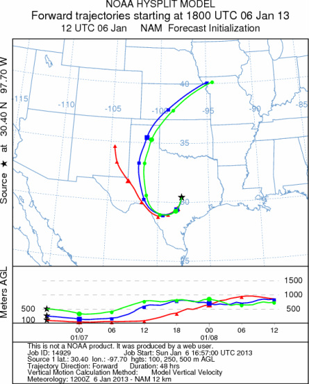
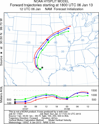
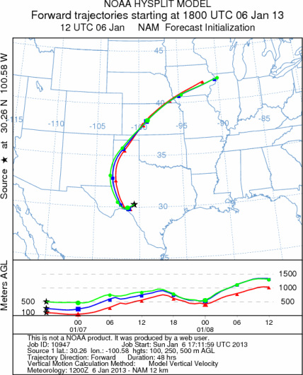
Trajectory Start (s) (shown by *
on map): Austin, TX; Junction, TX; Sonora, TX.
AUSTIN
JUNCTION
SONORA
EDWARDS PLATEAU COMPOSITE
Prepared by: Estelle
Levetin (Faculty of Biological
Science, The
University of Tulsa, 800 S. Tucker Dr., Tulsa, OK 74104) and ) and Peter
K Van de Water (Department of Earth and Environmental Science, California State University Fresno,
2576 East San Ramon Avenue, M/S ST24, Fresno CA 93740-8039). This forecast gives the anticipated future track of
released Mountain Cedar pollen, weather conditions over the region and along the forecast pathway, and an estimated
time of arrival for various metropolitan areas.
Questions: Aerobiology Lab e-mail: pollen@utulsa.edu
Return to Forecasting Home Page