
The University of Tulsa
Mountain Cedar Pollen Forecast
Metropolitan Area |
Exposure Risk |
|
Dallas/Fort Worth |
Low |
|
Austin |
Moderate |
|
San Antonio |
Moderate |
Date Issued: 7 January 2013
Mountain Cedar Location(s): Edwards Plateau, Texas
Regional Weather: Monday, January 7 TX/OK: Across
the region the weather will be warming. Skies will begin across the area as partly sunny to partly cloudy, but
those skies will darken and build towards the afternoon and into tonight and tomorrow with an increasing chance
of rain. High temperatures today will be in the upper 50s across the region with lite to moderate winds from the
east and southeast. Tonight clouds will build in as the east and southeasterly winds interact with a system moving
in from the west. The western system will bring moisture that will eventually build into showers and thunderstorms.
Tonight in the edge communities the chance of rain increases to 50% in Austin and 60% in San Antonio. The chance
of rain will also extend across the southern portion of the Edwards Plateau. Low temperatures tonight will be seasonal
with areas on the western Plateau and in Oklahoma in the 30s and lows in the 40s in the communities surrounding
the Edwards Plateau. Winds will remain lite from the east to southeast. Tomorrow rain will build across the entire
region. In Oklahoma a 30% chance of rain will occur in the Arbuckle Mountains. Across Texas the chance of rain
builds with showers and thunderstorms ranging from 60% to 100% in the edge communities. Winds will turn from the
east and southeast direction to coming from the northeast. They will remain lite at 5 to 10 mph. Temperatures will
return back into the 50s except for the far west where high 40s are expected. Tomorrow night rains continue to
build. Rain and thunderstorms are expected across the entire region. Low temperatures will be mild with most areas
remaining in the 40s and 50s. Winds will remain from the northeast and east at lite to moderate levels.
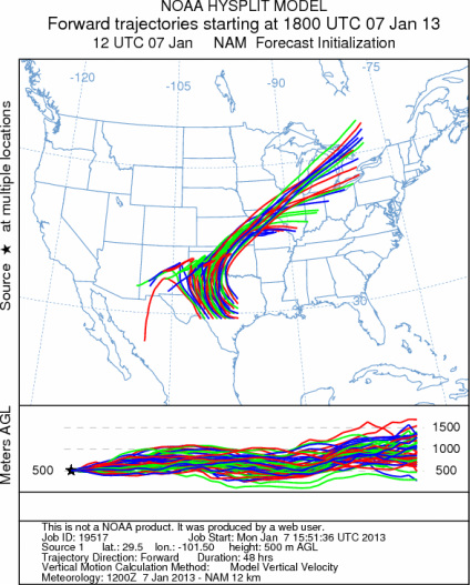
Trajectory weather: Air mass trajectories over the Edwards Plateau move northwestward on the east to southeasterly
winds today into tonight. As the next weather system from the west moves towards the region clouds will build and
the chance of showers will increase tonight across Texas first and then into Oklahoma. The wind trajectories will
encounter the system, thus initially moving northwestward but then travelling across the Panhandle of Texas and
then back to the northeast across west central Oklahoma and into southeast Kansas and into Missouri. The trajectories
show some buoyancy and thus pollen that is release today should become entrained into the atmosphere and be able
to travel downwind. Tomorrow, significant rain is expected across the region with showers and thunderstorms. Temperatures
will remain mild and winds will be from the northeast as the system from the west moves into the region. Tomorrow
night the chance of rain continues to build with most areas on the Edwards Plateau having a 90% to 100% chance
of precipitation. Winds will remain from the northeast at lite to moderate levels.
OUTLOOK: *** High Threat today and Low threat Tomorrow
*** Warming temperatures across the region for pollen release today ahead of major precipitation beginning
tonight and tomorrow. Conditions will be in the 50s starting with clear to partly cloudy skies today. Winds will
be lite from the east and southeast today. Temperatures today will move into the upper 50s on the Edwards Plateau
and in the surrounding edge communities. The chance of precipitation is low today but begins to build tonight with
tomorrow and tomorrow night expected to be wet. The atmosphere will be moderately buoyant and winds will move the
trajectories towards the northwest then loop back to the north-northeast moving over the Texas Panhandle, central
Oklahoma, then towards Missouri. Pollen entrained within the air mass will move past Oklahoma City then onward
towards St. Louis over the next 24 to 48 hours. Entrainment and travel with the interaction of the incoming moisture
may limit the amount of pollen flowing outside of the region. The trees will be shedding pollen as the region warms
and continues to dry out today, therefore pollen levels are expected to be high. Tonight moisture builds in with
significant rain expected tomorrow and tomorrow night. The tree population is approaching the heart of the historic
pollination season. Today there will be conditions for significant pollen levels in the atmosphere compared to
tomorrow when pollen will be constrained by the forecast precipitation.
Trajectory Start (s) (shown by *
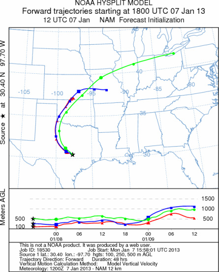
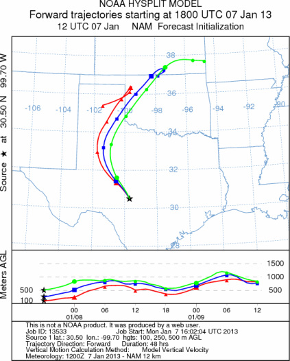
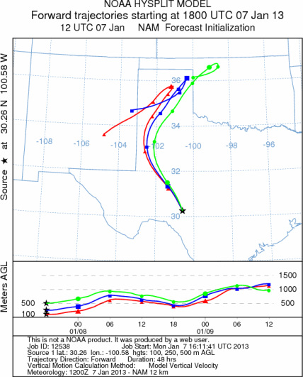
on map): Austin, TX; Junction, TX; Sonora, TX.
AUSTIN
JUNCTION
SONORA
EDWARDS PLATEAU COMPOSITE
Prepared by: Estelle
Levetin (Faculty of Biological
Science, The
University of Tulsa, 800 S. Tucker Dr., Tulsa, OK 74104) and ) and Peter
K Van de Water (Department of Earth and Environmental Science, California State University Fresno,
2576 East San Ramon Avenue, M/S ST24, Fresno CA 93740-8039). This forecast gives the anticipated future track of
released Mountain Cedar pollen, weather conditions over the region and along the forecast pathway, and an estimated
time of arrival for various metropolitan areas.
Questions: Aerobiology Lab e-mail: pollen@utulsa.edu
Return to Forecasting Home Page