
The University of Tulsa
Mountain Cedar Pollen Forecast
Metropolitan Area |
Exposure Risk |
|
Dallas/Fort Worth |
Low |
|
Austin |
Moderate to High |
|
San Antonio |
Moderate to High |
Date Issued: 12 January 2013
Mountain Cedar Location(s): Edwards Plateau, Texas
Regional Weather: Saturday, 12 Jan 2013 - OK/TX:
After a couple of warm days, the region will see changing weather again as a cold front moves southeast. Temperatures
in Oklahoma and north Texas are already dropping and will continue to drop throughout the day. Afternoon highs
will be in the 40s and will continue to drop into the 20s. Winds will be from 10 to 20 mph from the north. Areas
of rain will likely spread north of the front across much of eastern Oklahoma during Saturday afternoon. Precipitation
is expected to transition to a wintry mix Saturday evening across the northeast part of the state. Much colder
conditions are expected behind the front Sunday and Monday with temperatures in the 30s with partly cloudy skies
and moderate northerly winds. In Texas the front will slowly move across the state later on Saturday. As a result
temperatures in Texas will teach into the 60s in the north and 70s in the south. Rain is possible throughout the
region with a chance of thunderstorms in some areas. Winds will shift during the day from southerly to northerly
winds and temperatures will drop into the 30s to low 40s Saturday night. Sunday and Monday will be cooler with
highs in the 40s and 50s and winds from the north with partly cloudy skies.
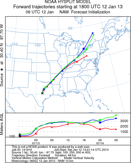
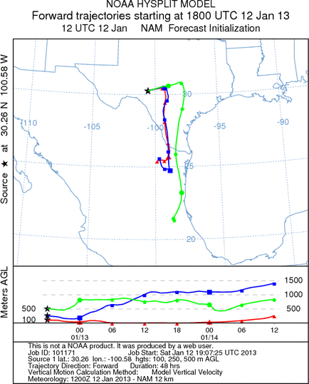
Trajectory weather: Air mass trajectories over the Edwards Plateau are variable today due to the frontal
system moving across Texas. From the eastern side of the Edwards Plateau, which is ahead of the cold front, the
air mass rapidly moves to the northeast across Arkansas, Illinois, and on into Canada. The air will be relatively
buoyant and may transport any entrained pollen over long distances. Ahead of the front the conditions are mild
with temperatures in the low 70s which are favorable for pollen release. However, high humidity and drizzle this
morning may inhibit pollen release. On the western side of the plateau the air mass trajectories move to the east
and then to the south as the frontal system moves through the area. Temperatures on the western side of the plateau
have begun dropping and will be in the low 50s by late this afternoon. A chance of rain will remain in most areas
into the evening hours. Temperatures will be much cooler tomorrow.
OUTLOOK: *** Mixed threat today and Low threat tomorrow
*** Mixed conditions for pollen release but favorable conditions for pollen transport from the eastern side
of the plateau. Conditions on the western side of the Edwards Plateau are mixed for pollen release and transport.
Tomorrow poor conditions for release. Temperatures are favorable for pollen release in many areas today but the
light rain overnight and high humidity may inhibit pollen release in some areas. This makes for a mixed forecast.
Some areas may see high pollen levels while others low to moderate. Conditions will degrade as the cold front enters
the area and become poor for pollen release for the next couple of days.
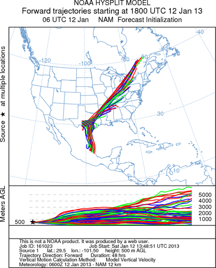
Trajectory Start (s) (shown by *
on map): Austin, TX; Junction, TX; Sonora, TX.
AUSTIN
JUNCTION

SONORA
EDWARDS PLATEAU COMPOSITE
Prepared by: Estelle
Levetin (Faculty of Biological
Science, The
University of Tulsa, 800 S. Tucker Dr., Tulsa, OK 74104) and ) and Peter
K Van de Water (Department of Earth and Environmental Science, California State University Fresno,
2576 East San Ramon Avenue, M/S ST24, Fresno CA 93740-8039). This forecast gives the anticipated future track of
released Mountain Cedar pollen, weather conditions over the region and along the forecast pathway, and an estimated
time of arrival for various metropolitan areas.
Questions: Aerobiology Lab e-mail: pollen@utulsa.edu
Return to Forecasting Home Page