
The University of Tulsa
Mountain Cedar Pollen Forecast
Metropolitan Area |
Exposure Risk |
|
Dallas/Fort Worth |
Low |
|
Austin |
Low |
|
San Antonio |
Low |
Date Issued: 14 January 2013
Mountain Cedar Location(s): Edwards Plateau, Texas
Regional Weather: Monday, January 14 TX/OK:
Across the region the weather will continue to be cold as the entire area will be under a northeasterly flow at
light to moderate conditions. High temperatures today will be in the mid to upper 40s in Texas and into the upper
30s in Oklahoma. Most of the skies will be partly cloudy except for the Dallas/Fort Worth metro area southward
towards the edge communities of Austin and San Antonio. Although sunny and partly sunny conditions will occur
the cold temperatures remain across the region. Tonight, partly cloudy skies will remain to the north with partly
cloudy skies building to mostly cloudy conditions across the Edwards Plateau and in the edge communities. Tonight
the region will drop into the 20s, except for the areas along the southern most Edwards Plateau where they will
try to stay in the low 30s. Winds will maintain themselves coming from the northeast at light levels. Tomorrow
partly cloudy conditions will remain to the north and mostly cloudy conditions over the Edwards Plateau and in
the surrounding communities. High temperatures will once again remain in the mid to lower 40s throughout the
region with winds building back to moderate conditions from the northeast. Tomorrow night the north, in Oklahoma,
will be mostly clear whereas to the south across Texas mostly cloudy skies will build in. Low temperatures will
return back into the mid to lower 20s on the Edwards Plateau and the lower 30s to the upper 20s in the surrounding
communities. In Oklahoma low temperatures are expected to drop into the teens with clear, cold conditions. Winds
will remain from the northeast at light to moderate conditions.
Trajectory weather: Air mass trajectories over the Edwards Plateau move southwest on northeasterly breezes
today, tonight and tomorrow. The winds will move the trajectory towards west Texas where swirling conditions will
cause the air masses to stagnate. The cold atmosphere will interact becoming warmer and more buoyant as the overall
trough of cold air begins to push east. However, winds will remain from the northeast over the entire forecast
period and cold conditions are expected during the day and very cold conditions at night. On Monday and Tuesday,
conditions warmer than the upper 40s will be hard to find anywhere across the region.
OUTLOOK: *** Moderate Threat today and Moderate threat Tomorrow *** Cold conditions
will occur today, tonight, tomorrow and tomorrow night. Skies will be mostly cloudy across the region. The exception
will be in Oklahoma where less cloud cover will occur but that will bring on colder night time temperatures. There
is a moderate threat for pollen release today and tomorrow. Conditions are not particularly good, and we usually
find cold conditions constrain any pollen release. However, we are in the middle of the period with the heaviest
pollen release and therefore there may be limited pollen that is released. We do not expect there to be significant
entrainment nor significant amount travelling downwind. The moderate threat is mostly in the areas with substantial
numbers of trees. Those living in and around the tree populations may receive significant exposure. Significant
amounts of pollen is expected in and around these areas (San Antonio, Austin, Waco, The Edwards Plateau), as well
as northward (Arbuckle Mountains of Oklahoma).
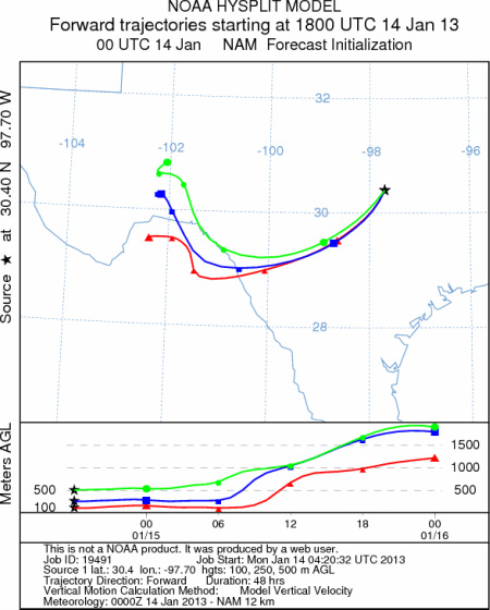
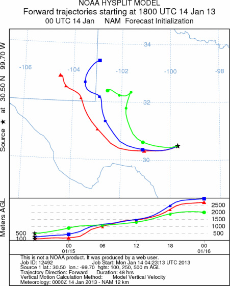
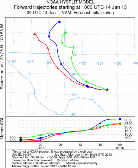
Trajectory Start (s) (shown by *
on map): Austin, TX; Junction, TX; Sonora, TX.
AUSTIN
JUNCTION
SONORA
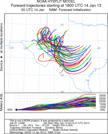
EDWARDS PLATEAU COMPOSITE
Prepared by: Estelle
Levetin (Faculty of Biological
Science, The
University of Tulsa, 800 S. Tucker Dr., Tulsa, OK 74104) and ) and Peter
K Van de Water (Department of Earth and Environmental Science, California State University Fresno,
2576 East San Ramon Avenue, M/S ST24, Fresno CA 93740-8039). This forecast gives the anticipated future track of
released Mountain Cedar pollen, weather conditions over the region and along the forecast pathway, and an estimated
time of arrival for various metropolitan areas.
Questions: Aerobiology Lab e-mail: pollen@utulsa.edu
Return to Forecasting Home Page