
The University of Tulsa
Mountain Cedar Pollen Forecast
Metropolitan Area |
Exposure Risk |
|
Dallas/Fort Worth |
Low |
|
Austin |
High |
|
San Antonio |
High |
Date Issued: 16 January 2013
Mountain Cedar Location(s): Edwards Plateau, Texas
Regional Weather: Wednesday, January 16 TX/OK:
Across the region the weather will begin to warm for today and tomorrow. Today sunny skies will dominate from
Oklahoma southward except for the Edwards Plateau. Temperatures will be in the 50s in most areas, lower 50s
north and on the Plateau, with mid 50s in the communities surrounding the Edwards Plateau. Winds will be lite
and variable to the north with increasing wind strength from the edge communities including Austin and San Antonio
across the Edwards Plateau. Most of those communities will see winds at moderate strengths with conditions become
strong on the Edwards Plateau during the afternoon. Winds of 15 to 20 mph with gusts in the 25 mph strength will
be common during the afternoon. Winds will be from the west early switching and coming out of the northwest later
in the day. Tonight the region will be mostly clear. Low temperatures will be in the low 30s in most localities.
On the western most portion of the Edwards Plateau nighttime reading in the upper 20s are expected. Winds will
be from the northwest at 5 to 15 mph across the region. Tomorrow sunny skies will greet the day with mostly sunny
conditions on the Edwards Plateau. Daytime temperatures will warm by 5 to 10 degrees. On the Edwards Plateau
temperatures will be in the mid 50s in most places. Winds will switch back coming from the north at lite to moderate
levels. Tomorrow night mostly clear skies will occur with temperatures in the upper 20s across the Edwards Plateau
and in the low 30s in the edge communities and northward into Oklahoma. Winds will remain from the north except
for the Edwards Plateau where winds will switch, coming from the southeast to east.
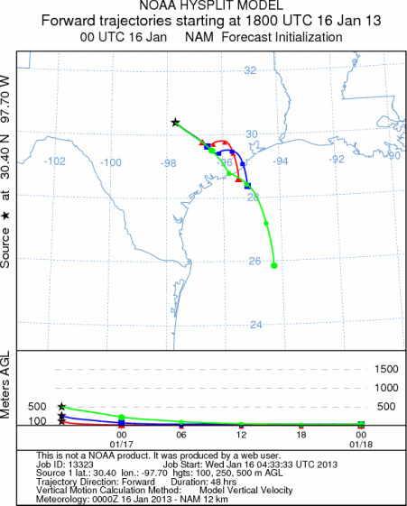
Trajectory weather: Air mass trajectories over the Edwards Plateau move southeast towards the Gulf of Mexico.
The trajectories will cross over much of the coastal region from approximately Corpus Christie to Houston, Texas.
The winds will be lite to moderate today and tonight while the winds come from the northwest. Tomorrow a northerly
flow begins once again during the day and into the evening. Tomorrow night the northerly winds will remain across
Texas except for the Edwards Plateau where a more southeasterly wind will take over. Temperatures today and tomorrow
will warm into the 50s with mostly sunny skies.
OUTLOOK: *** High Threat today and High Threat tomorrow *** Warming conditions
today with high temperatures expected to be in the low to mid 50s. Winds will be moderate to strong, especially
across the Edwards Plateau. Sunny skies will prevail today tonight and for all areas except the Edwards Plateau
tomorrow. Tomorrow sunny skies and temperatures about 5 degrees warmer are expected. Winds will calm from todays
winds but still be moderate and coming from the north. Tomorrow night mostly clear skies and temperatures in the
low 30s in the surrounding communities and 20s on the Edwards Plateau will occur. Winds will remain from the
north except from the Edwards Plateau where they will be from the southeast. Conditions will be good to excellent
for pollen release over the next two days. Warming conditions and being in the middle of the historical pollen
season should result in significant amounts of pollen along the trajectory pathway (southeast from the Edwards
Plateau over and area between Corpus Christi to Houston). The winds are cold and thus dense moving at or near
ground level. With the warming conditions significant pollen should be released and move towards the Gulf of Mexico.
Similar conditions will occur tomorrow as well, but a more northerly direction will shift the trajectories towards
south and southwest Texas.
Trajectory Start (s) (shown by *
on map): Austin, TX; Junction, TX; Sonora, TX.
AUSTIN
JUNCTION
SONORA
EDWARDS PLATEAU COMPOSITE
Prepared by: Estelle
Levetin (Faculty of Biological
Science, The
University of Tulsa, 800 S. Tucker Dr., Tulsa, OK 74104) and ) and Peter
K Van de Water (Department of Earth and Environmental Science, California State University Fresno,
2576 East San Ramon Avenue, M/S ST24, Fresno CA 93740-8039). This forecast gives the anticipated future track of
released Mountain Cedar pollen, weather conditions over the region and along the forecast pathway, and an estimated
time of arrival for various metropolitan areas.
Questions: Aerobiology Lab e-mail: pollen@utulsa.edu
Return to Forecasting Home Page