The University of Tulsa
Mountain Cedar Pollen Forecast

Metropolitan Area |
Exposure Risk |
|
Oklahoma City |
Low |
|
Tulsa |
Low |
|
St. Louis MO |
Low |
Date Issued: 21 January 2013
Mountain Cedar Location(s): Arbuckle Mountains, OK
Regional Weather: Monday, January 21 TX/OK:
Across the region the weather will rise to the 50s and 60s today with a dominant wind flow from the northeast.
Areas from Dallas/Fort Worth southward to the edge communities morning fog will be common. In Oklahoma high
temperatures will be in the 40s but with sunny skies, winds will be brisk (10 to 20 mph). To the south in Texas,
the edge communities will reach into the mid to upper 60s and the Edwards Plateau will be in the lower 50s to
the west and closer to 60 in the central portion of the Plateau. Tonight Oklahoma will remain clear, but southward
mostly cloudy skies will dominate. Low temperatures will remain above freezing with the Plateau in the mid to
upper 30s and the edge communities in the mid 40s. Winds in Oklahoma will fall to lite and variable conditions.
Across Texas winds in the edge communities will remain from the northeast at lite conditions. On the Plateau
winds will be from the south and southeast. Tomorrow sunny skies will occur to the north with temperatures in
the 50s. Winds will be lite from the south. Across Texas cloudy conditions will build from mostly sunny conditions
in Dallas/Fort Worth to mostly cloudy thinning to partly cloudy conditions over the Edwards Plateau. High temperatures
will rise to the mid 60s in most areas. Winds will start from the northeast at lite levels in the communities
surrounding the Edwards Plateau. The southern edge communities as well as on the Edwards Plateau winds will switch,
coming from the south. Winds will be lite to moderate. Tomorrow night clouds will build region wide with partly
cloudy conditions thickening overnight. Winds will be lite to moderate from the south. Low temperatures will
fall only into the mid-40s over the Plateau and near 50 in the surrounding communities.
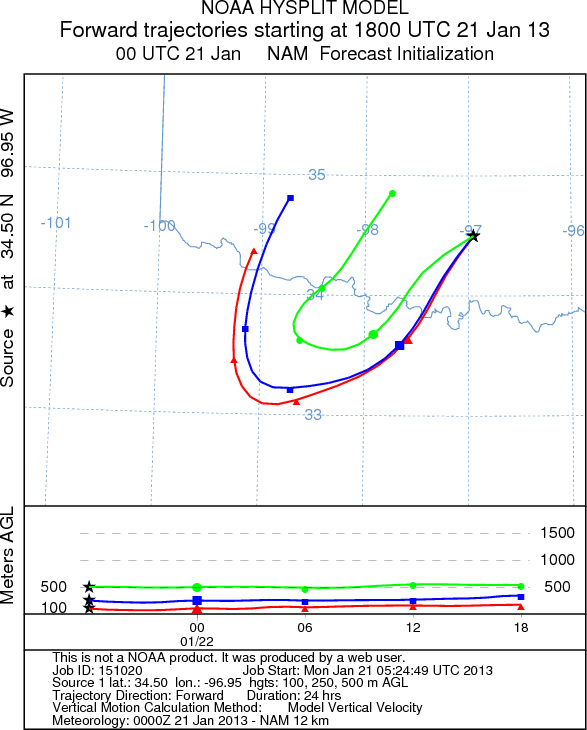
Trajectory weather: Air mass trajectories over the Arbuckle Mountains move initially to the southwest on
moderate northeasterly winds. Overnight winds will relax and a more southerly flow will take over. The trajectories
initially move southwest and turn back to the north to the west of the source area. The trajectories across the
Edwards Plateau to the south show that the lite wind conditions will tend to swirl the atmosphere over central
Texas. The trajectories from Texas may mover far enough north to interact with any pollen moving from southern
Oklahoma. Today temperatures will remain cool with highs expected in the upper 40s. Tomorrow temperatures are
expected to warm into the upper 50s. Today the colder air will keep the trajectories near the ground as the cold
temperatures keep the air dense. Cool temperatures and dense air should retard the entrainment and movement of
pollen from these populations. Tomorrow, however warmer conditions will improve the outlook.
OUTLOOK: *** Low Threat today and Moderate Threat tomorrow
*** Cool conditions today with high temperatures expected to only be in the upper 40s. Winds will begin moderate
then relax towards the evening. Sunny skies and partly sunny skies will prevail today, tonight, and tomorrow.
Tonight temperatures will drop below freezing. Tomorrow warmer conditions are expected with a southerly flow
moving into the region. Winds will be mixed shifting over the forecast period between today and tomorrow. Conditions
will be good for pollen release will build from poor conditions today to moderate conditions tomorrow. Warming
conditions and being in the middle of the historical pollen season should result in a good chance of pollen along
the trajectory pathway tomorrow. With the warming conditions significant pollen should be released and be entrained
into the atmosphere, impacting areas across Texas.
Trajectory Start (s) (shown by black
star on map): Davis, OK.
Prepared by: Estelle
Levetin
(Faculty
of Biological Science, The University of Tulsa, 800 S. Tucker Dr., Tulsa, OK 74104) and Peter
K Van de Water
(Department of Earth and Environmental Science, California State University Fresno, 2576 East San Ramon Avenue,
M/S ST24, Fresno CA 93740-8039). This forecast gives the anticipated future track of released Mountain Cedar pollen,
weather conditions over the region and along the forecast pathway, and an estimated time of arrival for various
metropolitan areas.
Questions: Aerobiology Lab e-mail: pollen@utulsa.edu
Return to Forecasting Home Page