
The University of Tulsa
Mountain Cedar Pollen Forecast
Metropolitan Area |
Exposure Risk |
|
Dallas/Fort Worth |
High |
|
Austin |
High |
|
San Antonio |
High |
Date Issued: 22 January 2013
Mountain Cedar Location(s): Edwards Plateau, Texas
Regional Weather: Tuesday, January 22 TX/OK:
Across the region the weather will show increasing cloudiness today especially over the Edwards Plateau and in
the surrounding communities. To the north in the Dallas/Fort Worth area into Oklahoma mostly sunny skies will
occur. In the area of the eastern Plateau and the surrounding communities from Austin to San Antonio, mostly cloudy
skies will occur. Temperatures will be in the upper 50s in Oklahoma and in the 60s across Texas. Winds across
the area will be moderate from the south except in the edge communities where initially a northeast flow will occur.
This afternoon the northeasterly winds will give way to a more southeasterly flow. Overnight the southerly flow
will bring warm temperatures into the area with the Plateau in the mid 40s for the low and the mid 50s in the
surrounding communities. Winds will remain from the south at lite to moderate conditions. In southern Oklahoma
temperatures will be in the low 40s to high 30s with lite and variable winds over the Arbuckle Mountains. Tomorrow
the Edward Plateau communities will see partly cloudy conditions giving way to clear skies during the day. The
areas surrounding the Plateau will be partly sunny. Temperatures will rise into the low to mid 70s with moderate
winds from the south and southwest. Temperatures will rise into the upper 60s northward into southern Oklahoma.
The southerly flow will dominate tomorrow into tomorrow night. Skies will be partly cloudy across the region
with mostly clear skies in Oklahoma. Temepratures will be mild overnight with most of the Edwards Plateau in the
upper to mid 40s, the surrounding communities north to southern Oklahoma in the mid to low 50s. Winds will remain
from the south to southwest at lite to moderate levels.
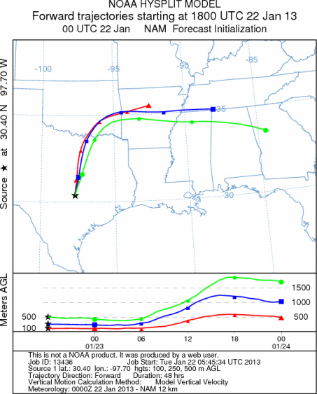
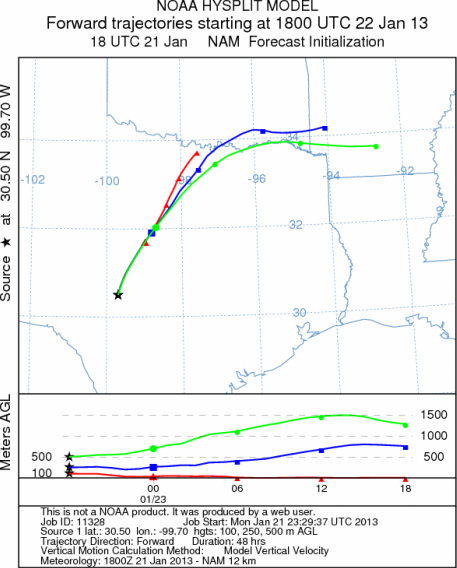
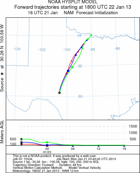
Trajectory weather: Air mass trajectories over the Edwards Plateau move northward on the southern to southwestern
flow across the state. In the area of northern Texas along the border with Oklahoma the trajectories are turned
almost due east flowing into southern Arkansas. The trajectories show that the lite to moderate wind conditions
will tend to move the atmosphere northward and then become a more concentrated path towards the east as the change
in winds occur. With warm conditions the air will be buoyant and thus pollen that is released should be entrained
and move with the winds. Tonight, winds will begin to be dominated with the southerly flow. The southeasterly
direction warmer conditions are forecast for tomorrow with most of the region getting into the 70s. Over the
Edwards Plateau tomorrow, partly cloudy conditions will begin the day clearing to sunny skies with partly sunny
skies to the north. Winds will remain from the south at lite to moderate conditions. Tomorrow night clouds will
thicken back to partly cloudy conditions. The low temperatures will be mild with southerly winds remaining across
the region. Lows will be in the upper 40s across the plateau and in the mid 50s in the surrounding communities.
OUTLOOK: *** High Threat today and High Threat tomorrow *** Mild conditions today
with high temperatures expected to be in the upper 50s and 60s region wide. Winds will be lite to moderate.
Mostly cloudy skies giving way to partly cloudy skies will characterize the area today on the Edwards Plateau
and in the surrounding communities. Tonight partly cloudy skies will dominate the Edwards Plateau with mostly
cloudy skies in the surrounding areas and to the north. Winds will be from the south at lite to moderate levels.
Conditions will be good for pollen release over the next two days and the air will be buoyant for good entrainment.
Warm conditions and being in the middle of the historical pollen season should result in significant amounts of
pollen along the trajectory pathways (north from the Edwards Plateau across the Dallas/Fort Worth metro region
and then moving abruptly towards the east into southern Arkansas and perhaps northernmost Louisiana.). With the
warming conditions significant pollen should be released and be entrained into the atmosphere, impacting areas
across Texas.
Trajectory Start (s) (shown by *
on map): Austin, TX; Junction, TX; Sonora, TX.
AUSTIN
JUNCTION
SONORA
EDWARDS PLATEAU COMPOSITE
Prepared by: Estelle
Levetin (Faculty of Biological
Science, The
University of Tulsa, 800 S. Tucker Dr., Tulsa, OK 74104) and ) and Peter
K Van de Water (Department of Earth and Environmental Science, California State University Fresno,
2576 East San Ramon Avenue, M/S ST24, Fresno CA 93740-8039). This forecast gives the anticipated future track of
released Mountain Cedar pollen, weather conditions over the region and along the forecast pathway, and an estimated
time of arrival for various metropolitan areas.
Questions: Aerobiology Lab e-mail: pollen@utulsa.edu
Return to Forecasting Home Page