
The University of Tulsa
Mountain Cedar Pollen Forecast
Metropolitan Area |
Exposure Risk |
|
Dallas/Fort Worth |
High |
|
Austin |
High |
|
San Antonio |
High |
Date Issued: 23 January 2013
Mountain Cedar Location(s): Edwards Plateau, Texas
Regional Weather: Wednesday, January 23 TX/OK:
Across the region the weather will show increasing cloudiness today especially over the Edwards Plateau and in
the surrounding communities. This morning patchy fog was expected across the region. Sunny skies will break through
from central Oklahoma southward towards the Edwards Plateau and in the surrounding communities. Over the Edwards
Plateau mostly to partly cloudy conditions will begin the day becoming clear in the afternoon. Temperatures will
be warm with almost the entire region expected to be in the mid to upper 70s. Winds will be from the south starting
at lite levels this morning building to moderate and moderately strong conditions this afternoon. Winds will be
from the south. Overnight mostly clear conditions will remain expect for the surrounding communities where dense
fog will build in. The Edwards Plateau today will see patchy fog conditions. Low temperatures will be mild with
most areas in the upper 40s to mid 50s. To the north of the Arbuckle Mountains a chance of rain will begin to
develop tomorrow (20% chance). Skies to the north will be partly cloudy with Oklahoma City reaching to get into
the upper 30s but to the south in the Arbuckle Mountains the low 50s are expected. Winds will be from the northeast
at lite to moderate conditions. To the south mostly sunny going to partly sunny conditions will occur from the
Dallas/Fort Worth area southward through the communities that occur along the edge of the Edwards Plateau. The
Edwards Plateau will remain partly cloudy. Temperatures on the Edwards Plateau will be very warm with highs expected
in the upper 70s today. In the edge communities high temperatures will reach into the mid 70s. Winds will be
from the south and southwest at lite to moderate conditions. Tomorrow night across Texas, partly to mostly cloudy
conditions will return. There is a chance of dense fog and drizzle in and around edge communities. Temperatures
will fall back into the 50s and 40s on the Plateau similar to tonights low temperatures. Winds will remain
from the south at lite conditions.
Trajectory weather: Air mass trajectories over the Edwards Plateau move northward on the southern to southwestern
flow across the state. In the area of northern Texas along the border with Oklahoma the trajectories begin to
interact with a system moving to the east north of the border area. From the release area the winds will be lite
to begin with and the air will move close to the ground. As the system to the north interacts with the air over
northern Texas it will become more buoyant and able to hold and transport pollen. The trajectories show that the
lite to moderate wind conditions will tend to move the atmosphere northward and then become a more concentrated
path towards the east with entrainment as the air mixes. Overnight mild lows with most areas in the upper 40s
and mid 50s with occur with mild winds continuing from the south to southwest. Tomorrow warm conditions return
and the dominant southwesterly flow will remain. Winds will be lite to moderate from the southwest. Tomorrow
night will mimic tonight in terms of the low temperatures and the lite southerly flow.
OUTLOOK: *** High Threat today and High threat Tomorrow *** Mild conditions today
with high temperatures expected to be in the 70s region wide. Winds will be lite to moderate. Mostly cloudy
skies giving way to partly cloudy skies will characterize the area today on the Edwards Plateau and in the surrounding
communities with mostly sunny to sunny skies in the surrounding areas. Tonight cloudy skies will build as moisture
is pulled in on the dominate southerly winds. Conditions will be very good for pollen release over the next two
days. The air will stable across most of the area but to the north where the trajectories encounter the systems
moving east it will become more buoyant and very good for maintaining entrainment. Warm conditions and being
in the middle of the historical pollen season should result in significant amounts of pollen along the trajectory
pathways (north from the Edwards Plateau across the Dallas/Fort Worth metro region and then moving eastward into
eastern Oklahoma and across Arkansas. Some pollen may make it as far west as the Tulsa metro region). With the
warming conditions significant pollen should be released and be entrained into the atmosphere, impacting areas
across Texas.
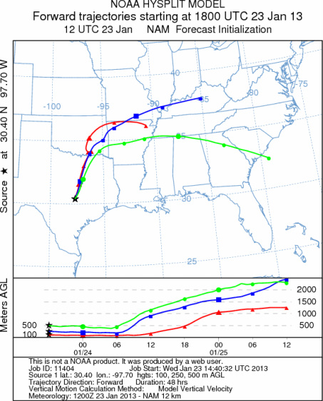
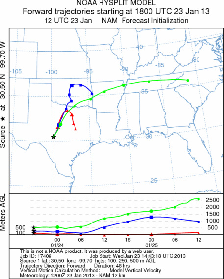
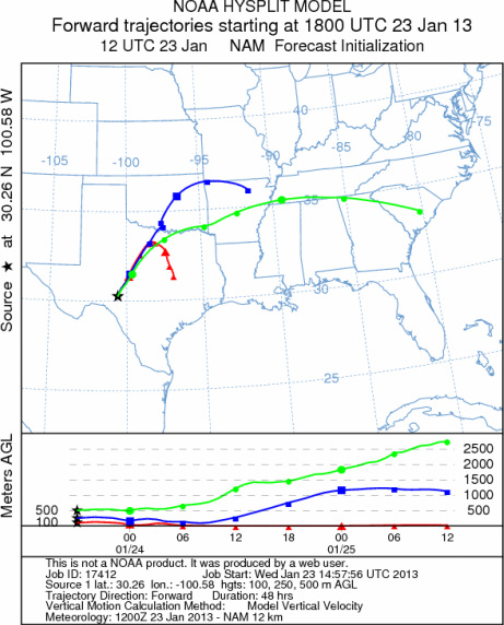
Trajectory Start (s) (shown by *
on map): Austin, TX; Junction, TX; Sonora, TX.
AUSTIN
JUNCTION
SONORA
EDWARDS PLATEAU COMPOSITE
Prepared by: Estelle
Levetin (Faculty of Biological
Science, The
University of Tulsa, 800 S. Tucker Dr., Tulsa, OK 74104) and ) and Peter
K Van de Water (Department of Earth and Environmental Science, California State University Fresno,
2576 East San Ramon Avenue, M/S ST24, Fresno CA 93740-8039). This forecast gives the anticipated future track of
released Mountain Cedar pollen, weather conditions over the region and along the forecast pathway, and an estimated
time of arrival for various metropolitan areas.
Questions: Aerobiology Lab e-mail: pollen@utulsa.edu
Return to Forecasting Home Page