The University of Tulsa
Mountain Cedar Pollen Forecast

Metropolitan Area |
Exposure Risk |
|
Oklahoma City |
Moderate |
|
Tulsa |
Moderate |
|
St. Louis MO |
Low |
Date Issued: 24 January 2013
Mountain Cedar Location(s): Arbuckle Mountains, OK
Regional Weather: Thursday, January 24 TX/OK:
Across the region the weather will show increasing to mostly cloudy conditions today especially over the Edwards
Plateau and in the surrounding communities. This morning patchy fog was expected across the region with drizzle
and a 20% chance of rain will occur in central Oklahoma. Mostly cloudy will build across south Oklahoma. To the
south very warm conditions area expected but in southern Oklahoma temperatures will struggle to get much above
50 degrees. Over the Edwards Plateau mostly to partly cloudy conditions will begin the day becoming clear in
the afternoon. Temperatures will be warm with almost the entire region expected to be in the mid to upper 70s.
Winds will be from the south starting at lite levels this morning building to moderate conditions this afternoon.
Winds will be from the south. Overnight partly to mostly cloudy conditions will remain with low temperatures
below freezing in central Oklahoma and in the low to mid 30s towards the border with Texas. Tomorrow skies will
remain partly cloudy with high temperatures in the low 50s. Winds will be from the north at lite levels. Tomorrow
night partly cloudy conditions will occur with low temperatures dropping into the 30s but staying above freezing.
Winds will remain from the northeast at lite to lite and variable conditions.
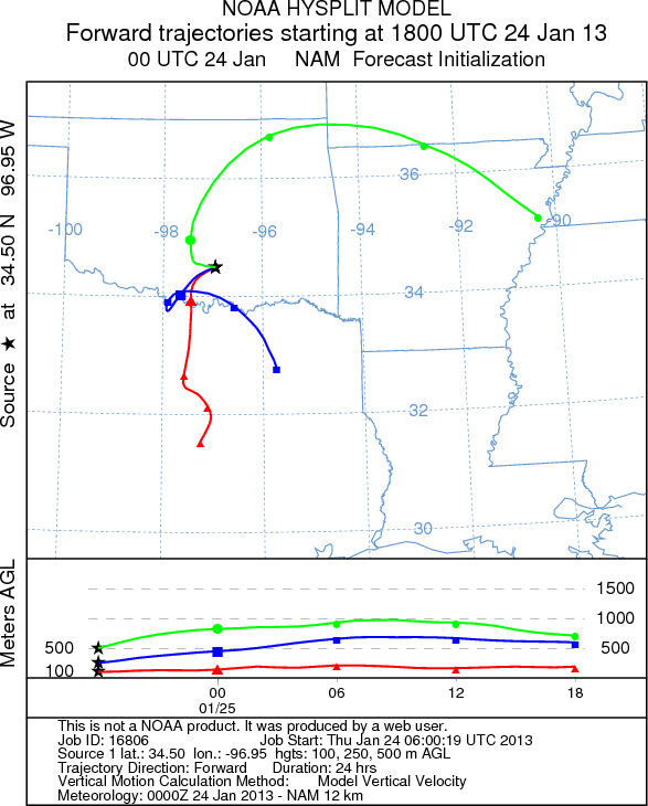
Trajectory weather: At different elevations, the air mass trajectories over the Arbuckle Mountains move
in different directions. The trajectories at near ground level, move due south on northerly winds. At upper levels
the trajectories continue to move south but at the highest modeled levels the air move northward. The air appears
to be stable with slight buoyancy. Today the temperatures will struggle to reach into the low 50s today and tomorrow.
Winds area expected to be lite and from the north to the northeast, thus the next two days should see winds from
the Arbuckle Mountains moving southward into Texas. Tomorrow night low temperatures will continue to fall with
the Arbuckle Mountain region expected in the mid to low 30s.
OUTLOOK: *** High Threat today and High threat Tomorrow *** Warm conditions today
with high temperatures expected to be in the low 50s in southern Oklahoma and in the 70s across Texas. Winds
will start at lite levels today and become lite and variable overnight. Tomorrow winds will be from the north
at 10 miles per hour becoming lite and variable tomorrow night. Today, with the northeasterly wind direction partly
cloudy conditions will begin to build with a 20% chance of drizzle and rain to the north in Oklahoma City. Tonight
temperatures will drop into the lower 30s with highs tomorrow expected to only reach into the low 50 degree range.
Conditions will be moderate for pollen release both today and tomorrow. Moderate conditions will occur but being
in the middle of the historical pollen season should result in a better chance of pollen along the trajectory pathways
both today and tomorrow. With the warming conditions significant pollen should be released and if entrained will
move southward into Texas.
Trajectory Start (s) (shown by black
star on map): Davis, OK.
Prepared by: Estelle
Levetin
(Faculty
of Biological Science, The University of Tulsa, 800 S. Tucker Dr., Tulsa, OK 74104) and Peter
K Van de Water
(Department of Earth and Environmental Science, California State University Fresno, 2576 East San Ramon Avenue,
M/S ST24, Fresno CA 93740-8039). This forecast gives the anticipated future track of released Mountain Cedar pollen,
weather conditions over the region and along the forecast pathway, and an estimated time of arrival for various
metropolitan areas.
Questions: Aerobiology Lab e-mail: pollen@utulsa.edu
Return to Forecasting Home Page