The University of Tulsa
Mountain Cedar Pollen Forecast

Metropolitan Area |
Exposure Risk |
|
Oklahoma City |
Low |
|
Tulsa |
Low |
|
St. Louis MO |
Low |
Date Issued: 25 January 2013
Mountain Cedar Location(s): Arbuckle Mountains, OK
Regional Weather: Friday, January 25 TX/OK:
Across the region the weather will be partly cloudy except in the corridor from Dallas/Fort Worth southward along
the edge of the Edwards Plateau where partly sunny conditions will occur. Oklahoma will be cool with high temperatures
in the 50s with light northerly winds. Temperatures to the south will be warm with highs across the Edwards Plateau
in the mid 70s to the west and into the 80s across the eastern Plateau region. In the surrounding edge communities,
temperatures will be in the upper 70s. Winds will be from the north at moderate conditions over the Edwards Plateau,
but a southerly flow will occur in the surrounding edge communities. Tonight cloudy conditions will build with
low temperatures mild in the edge communities, mid to upper 50s, and cooler over the Edwards Plateau, upper 30s
to mid 40s. To the north in Oklahoma low temperatures will be in the thirties but above the freezing level.
To the south in Texas, winds will be lite from the north to northeast. Overnight a chance of fog and drizzle will
build in the edge communities. Tomorrow, mostly cloudy conditions will occur across Oklahoma, and cloudy conditions
will dominate to the south as well. The edge communities will continue to see patchy fog and drizzle in the morning.
During the day temperatures will warm but cooling from today. High temperatures on the Edwards Plateau will be
in the upper 60s and in the low 70s in the edge communities. Winds will move to a dominant flow from the east
in the surrounding communities and from the southeast at moderate levels across the Edwards Plateau. Tomorrow
night cloudy and mostly cloudy skies remain. Low temperatures across region will be in the 50s with patchy fog
and drizzle in the surrounding communities. Winds will be from the southeast at lite levels and from the south
at moderate levels over the Edwards Plateau. In southern Oklahoma there will be a 40% chance of rain with temperatures
in the upper 40s.
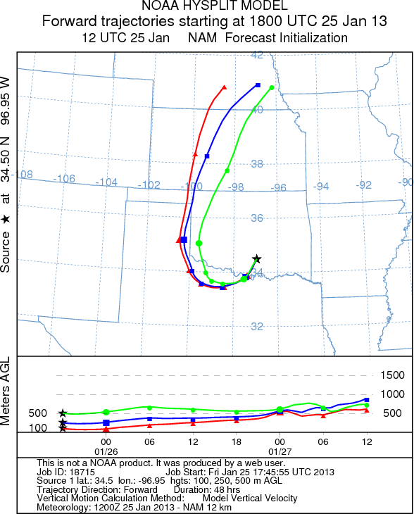
Trajectory weather: Air mass trajectories from the Arbuckle Mountains initially move southwest on northeast
winds, which are prevalent across much of Oklahoma today. The trajectories curve around to the west and then to
the north overnight and tomorrow as a southerly flow returns. The air appears to be stable with good buoyancy.
Today the temperatures at the source area will struggle to reach into the low 50s today and be in the low to mid-30s
overnight. Tomorrow will warm into the mid 50s. Winds are expected to be light and from the north to the northeast
this afternoon, and shift to southerly winds tomorrow afternoon.
OUTLOOK: *** Moderate Threat today and High Threat tomorrow
*** Warm conditions today with high temperatures expected to be in the low 50s in southern Oklahoma. Winds
will start at light levels today and become variable overnight. Tomorrow winds will be from the east and shifting
to the south at 10 miles per hour becoming light and variable tomorrow night. Tonight temperatures will drop into
the lower 30s with highs tomorrow expected to only reach into the mid 50s. Conditions will be moderate for pollen
release today and improving to good conditions tomorrow. Moderate conditions will occur but being in the middle
of the historical pollen season should result in a better chance of pollen along the trajectory pathways both today
and tomorrow. With the warming conditions significant pollen should be released and if entrained will move southward
into Texas and then back around to western Oklahoma.
Trajectory Start (s) (shown by black
star on map): Davis, OK.
Prepared by: Estelle
Levetin
(Faculty
of Biological Science, The University of Tulsa, 800 S. Tucker Dr., Tulsa, OK 74104) and Peter
K Van de Water
(Department of Earth and Environmental Science, California State University Fresno, 2576 East San Ramon Avenue,
M/S ST24, Fresno CA 93740-8039). This forecast gives the anticipated future track of released Mountain Cedar pollen,
weather conditions over the region and along the forecast pathway, and an estimated time of arrival for various
metropolitan areas.
Questions: Aerobiology Lab e-mail: pollen@utulsa.edu
Return to Forecasting Home Page