
The University of Tulsa
Mountain Cedar Pollen Forecast
Metropolitan Area |
Exposure Risk |
|
Dallas/Fort Worth |
High |
|
Austin |
HIgh |
|
San Antonio |
High |
Date Issued: 25 January 2013
Mountain Cedar Location(s): Edwards Plateau, Texas
Regional Weather: Friday, January 25 TX/OK:
Across the region the weather will be partly cloudy except in the corridor from Dallas/Fort Worth southward along
the edge of the Edwards Plateau where partly sunny conditions will occur. Oklahoma will be cool with high temperatures
in the 50s with lite northerly winds. Temperatures to the south will be warm with highs across the Edwards Plateau
in the mid 70s to the west and into the 80s across the eastern Plateau region. In the surrounding edge communities,
temperatures will be in the upper 70s. Winds will be from the north at moderate conditions over the Edwards Plateau,
but a southerly flow will occur in the surrounding edge communities. Tonight cloudy conditions will build with
low temperatures mild in the edge communities, mid to upper 50s, and cooler over the Edwards Plateau, upper 30s
to mid 40s. To the north in Oklahoma low temperatures will be in the thirties but above the freezing level.
To the south in Texas, winds will be lite from the north to northeast. Overnight a chance of fog and drizzle will
build in the edge communities. Tomorrow, mostly cloudy conditions will occur across Oklahoma, and cloudy conditions
will dominate to the south as well. The edge communities will continue to see patchy fog and drizzle in the morning.
During the day temperatures will warm but cooling from today. High temperatures on the Edwards Plateau will be
in the upper 60s and in the low 70s in the edge communities. Winds will move to a dominant flow from the east
in the surrounding communities and from the southeast at moderate levels across the Edwards Plateau. Tomorrow
night cloudy and mostly cloudy skies remain. Low temperatures across region will be in the 50s with patchy fog
and drizzle in the surrounding communities. Winds will be from the southeast at lite levels and from the south
at moderate levels over the Edwards Plateau. In southern Oklahoma there will be a 40% chance of rain with temperatures
in the upper 40s.
Trajectory Weather: Air mass trajectories over the Edwards Plateau move northeastward on south to southwesterly
flow across the state at 500 m. On the ground there will be an overall flow from the north to northeast as the
air will be very bouyant. Very warm conditions will cause surface warming across the region acting to lift the
atmosphere and drawing surface winds in from the north. The trajectories will move at 500 m towards the east over
northeast Texas. Over the region, temperatures are expected to reach into the upper 70s today and even stretch
to the 80s in the central area of the Plateau. Tonight cloudy skies will move in and most areas will return to
lite winds and seasonally mild low temperatures. Tomorrow temperatures will cool by 10 to 15 degrees over the
Plateau, but will remain in the temperature range that pollen is released. The edge communities will start the
day with the potential of patchy fog and drizzle. Winds will remain lite from the east except on the Plateau where
a southeasterly flow will be lite to moderate. Low temperatures tomorrow night will be in the 50s across the
region.
OUTLOOK: *** High Threat today and High Threat tomorrow *** Mild to warm conditions
today with high temperatures expected to be in the 70s region wide, and approaching the 80s on the Edwards Plateau.
The strong heating will cause the winds to become lite and rise in the atmosphere resulting in buoyancy. Winds
will be lite to moderate from the north to replace the rising air. Partly cloudy skies will characterize the area
today on the Edwards Plateau and in the surrounding communities. Tonight partly cloudy skies will build as moisture
is pulled in from clouds moving in from the southwest. Conditions will be very good for pollen release over the
next two days. Warm conditions and being in the middle of the historical pollen season should result in significant
amounts of pollen along the trajectory pathways (north from the Edwards Plateau across the Dallas/Fort Worth metro
region and then moving eastward into northeast Texas). With the warming conditions significant pollen should be
released and be entrained into the atmosphere, impacting areas across Texas.
Trajectory Start (s) (shown by *
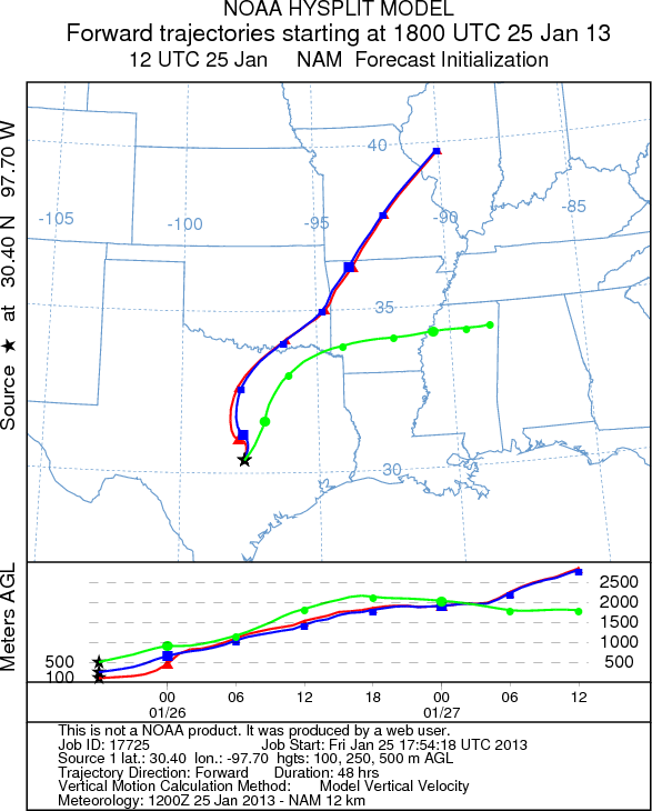
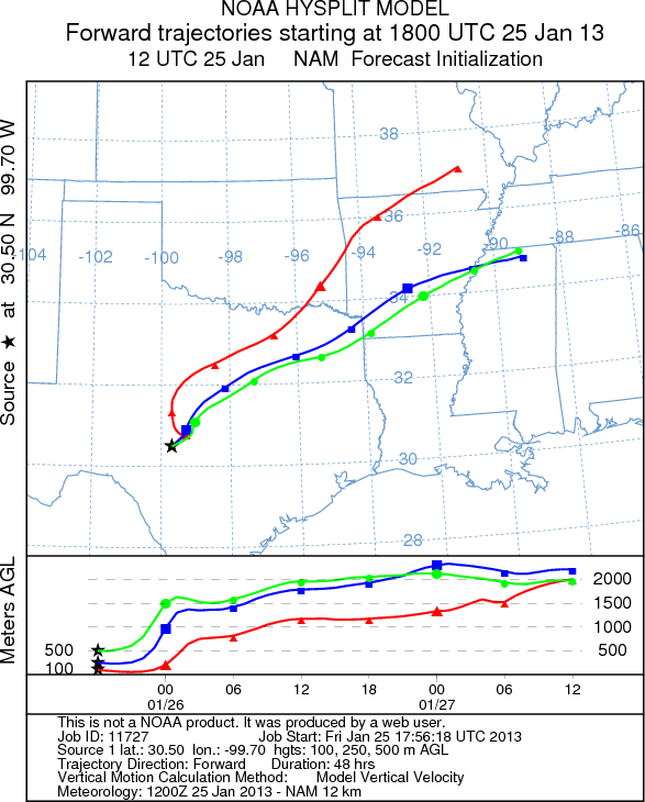
on map): Austin, TX; Junction, TX; Sonora, TX.
AUSTIN
JUNCTION
SONORA
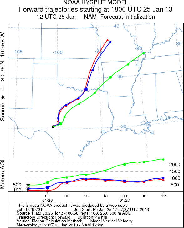
EDWARDS PLATEAU COMPOSITE
Prepared by: Estelle
Levetin (Faculty of Biological
Science, The
University of Tulsa, 800 S. Tucker Dr., Tulsa, OK 74104) and ) and Peter
K Van de Water (Department of Earth and Environmental Science, California State University Fresno,
2576 East San Ramon Avenue, M/S ST24, Fresno CA 93740-8039). This forecast gives the anticipated future track of
released Mountain Cedar pollen, weather conditions over the region and along the forecast pathway, and an estimated
time of arrival for various metropolitan areas.
Questions: Aerobiology Lab e-mail: pollen@utulsa.edu
Return to Forecasting Home Page