
The University of Tulsa
Mountain Cedar Pollen Forecast
Metropolitan Area |
Exposure Risk |
|
Dallas/Fort Worth |
High |
|
Austin |
High |
|
San Antonio |
High |
Date Issued: 26 January 2013
Mountain Cedar Location(s): Edwards Plateau, Texas
Regional Weather: Saturday, January 26 TX/OK:
Across the region the weather will see a lot of moisture with mostly cloudy to cloudy skies over the forecast period.
Although the air will be moist areas across Texas will still reach into the 70s both today and tomorrow. Mostly
cloudy conditions will occur across Oklahoma today, and mostly cloudy conditions will dominate to the south as
well. The edge communities will continue to see patchy fog and drizzle in the morning. During the day temperatures
will warm into the mid 60s to mid 70s in the edge communities, and in the upper 60s into the low 70s across
the Edwards Plateau. Winds will be from the east at lite conditions, except over the Plateau region where a dominant
south to southeasterly flow will occur starting as lite winds building to moderate conditions this afternoon.
Tonight partly cloudy to cloudy conditions will remain. To the north there will be a 40% to 20% chance of rain
from the Oklahoma City area south towards the border with Texas. Southward in Texas patchy fog and drizzle are
possible from the Dallas/Fort Worth metro region south to the edge communities. Overnight temperatures will be
mild mostly in the 50s. Winds will be lite to moderate from the southeast. Tomorrow, mostly cloudy conditions
will begin the day with a slight chance of rain in central Oklahoma and the return of patchy fog and drizzle to
the south from the Dallas/Fort Worth area into the communities surrounding the Edwards Plateau. High temperatures
will bounce back into the 70s across the region. Winds will be lite to moderate from the south. Tomorrow night
cloudy skies will remain with drizzle in the edge communities. Low temperatures will remain mild with lows only
falling into the mid 50s to the mid 60s. The winds remain at lite to moderate levels from the south.
Trajectory weather: The air mass trajectories over the Edwards Plateau move to the north across Oklahoma
and onward into the upper Midwest crossing eastern Kansas, Missouri, Iowa and towards the Great Lakes region.
The trajectories at ground level will be stable and move along the ground to begin with as they travel downwind.
Today the temperatures will be in the 60s and 70s across Texas warming into the 70s region wide tomorrow.
In Oklahoma the temperatures will be in the 40s and 50s today but warm into the 60s tomorrow. Today the winds
start from the east and southeast over the Edwards Plateau. The southeast flow will become dominant tonight and
the strength of those winds will increase tonight into tomorrow becoming moderate. Moderate winds will remain
tomorrow night. Both today and tomorrow nighttime moisture will occur with fog and drizzle in and around the communities
in Texas from Dallas/Fort Worth area southward to the edge communities. Warm temperatures will burn off the fog
and drizzle in the mornings. In Oklahoma tonight there is a slight chance of precipitation.
OUTLOOK: *** Severe Threat today and Severe threat Tomorrow *** Warm conditions
today with high temperatures expected to be in the mid 50s in southern Oklahoma and much warmer to the south across
Texas. Winds will be lite today building to moderate conditions tonight and tomorrow. Today, mostly cloudy skies
will build over the region and moisture will result in patchy fog and drizzle in areas surrounding the Edwards
Plateau. Warm conditions across Texas and moderate winds will result in good conditions for pollen release both
today and tomorrow. Pollen moving north will impact communities across a wide swath that include major metro regions
(Oklahoma City, Tulsa, St. Louis). The air will be stable in most areas and thus entrainment will be moderate
and will move along the ground surface where impaction removes much of it from the air stream. That being said,
we are in the middle of the historical pollen season should result in a better chance of pollen moving along the
trajectory pathways both today and tomorrow. For these reasons a significant chance of pollen moving northward
from Texas to the north is expected.
Trajectory Start (s) (shown by *
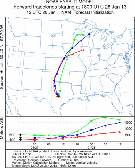
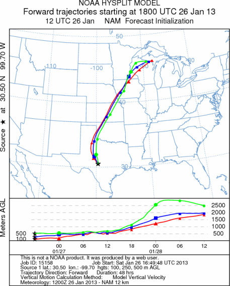
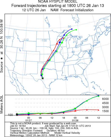
on map): Austin, TX; Junction, TX; Sonora, TX.
AUSTIN
JUNCTION
SONORA
EDWARDS PLATEAU COMPOSITE
Prepared by: Estelle
Levetin (Faculty of Biological
Science, The
University of Tulsa, 800 S. Tucker Dr., Tulsa, OK 74104) and ) and Peter
K Van de Water (Department of Earth and Environmental Science, California State University Fresno,
2576 East San Ramon Avenue, M/S ST24, Fresno CA 93740-8039). This forecast gives the anticipated future track of
released Mountain Cedar pollen, weather conditions over the region and along the forecast pathway, and an estimated
time of arrival for various metropolitan areas.
Questions: Aerobiology Lab e-mail: pollen@utulsa.edu
Return to Forecasting Home Page