
The University of Tulsa
Mountain Cedar Pollen Forecast
Metropolitan Area |
Exposure Risk |
|
Dallas/Fort Worth |
Moderate |
|
Austin |
Moderate |
|
San Antonio |
Moderate |
Date Issued: 27 January 2013
Mountain Cedar Location(s): Edwards Plateau, Texas
Regional Weather: Sunday, January 27 TX/OK:
Across the region the weather will see a lot of moisture with mostly cloudy to cloudy skies over the forecast period.
Although the air will be moist areas across Texas will still reach into the 70s both today and tomorrow. Mostly
cloudy conditions will occur across southern Oklahoma today, and cloudy conditions will dominate to the south,
except on the Edwards Plateau where partly cloudy conditions will evolve during the day. Across Texas patchy fog
will occur in the morning hours with a chance of drizzle and showers developing in the communities surrounding
the Edwards Plateau. Temperatures will be in the mid-70s across the region. Winds will be from the south at
lite to moderate conditions across Texas and reaching into strong conditions across Oklahoma. Tonight mostly cloudy
skies will remain across the northern areas and cloudy conditions over the Edwards Plateau. Low temperatures will
be very mild with the mid to upper 50s in Oklahoma, mid to lower 60s in region from Dallas/Fort Worth to Austin
and over to San Antonio. On the Edwards Plateau lows tonight will be in the mid to upper 50s. Winds will remain
from the south at lite to moderate conditions. Tonight and tomorrow there is a 20% chance of precipitation over
the Arbuckle Mountains and winds will be strong getting above 20 mile per hour. Tomorrow, fog and drizzle will
occur in edge communities surrounding the southern portion of the Edwards Plateau. Both Austin and San Antonio
will have a 20% chance of precipitation. Across the region high temperatures will climb into the mid to upper
70s. Winds will maintain their southerly flow with many areas seeing moderately strong conditions. Tomorrow
night mostly cloudy and cloudy conditions continue. From Oklahoma City southward around the Edwards Plateau edge
there will be a 20% chance of precipitation in the form of showers. Nighttime temperatures will fall into the
low 60s off of the Edwards Plateau and into the mid to upper 50s on the Plateau. Winds will continue from the
south at lite to moderate conditions.
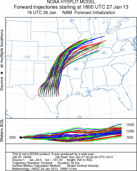
Trajectory weather: The air mass trajectories over the Edwards Plateau move to the north across Oklahoma
and onward into eastern Kansas and then over Missouri. The trajectories at ground level will be stable and move
along the ground to begin with as they travel downwind. Today the temperatures will be in the mid 70s across
Texas warming into the upper 70s region wide tomorrow. In Oklahoma the temperatures will be in the upper 60s
today and then warm into the mid 70s tomorrow. Both days, across the entire region there will be high levels
of moisture resulting in early fog and drizzle. Locations with the greatest chance of showers along with the high
humidity will be the southern edge communities from Austin to San Antonio. However, even the Edwards Plateau may
see patchy morning fog today. Winds will be moderate today from the south. The southerly flow will occur during
the entire forecast period. Tomorrow the moisture will remain and the edge communities will have a 20% chance
of showers along with early morning fog and drizzle. The region will be very warm with temperatures in the 70s.
Tomorrow night the chance of rain, 20%, will develop over the eastern side of the Edwards Plateau and into the
edge communities. Winds will remain from the south at lite to moderate conditions.
OUTLOOK: *** Moderate Threat today and Moderate threat Tomorrow *** Warm conditions
today and tomorrow with high temperatures expected to be close to or in the 70s today. Winds will be lite to
moderate across Texas and building to strong conditions in Oklahoma. The southerly flow will remain tonight, tomorrow
and tomorrow night. Today, cloudy skies will build over the region and moisture will result in patchy fog and
drizzle in areas surrounding the Edwards Plateau. The moisture will build tomorrow resulting in a 20% chance of
showers tomorrow and tomorrow night. Warm conditions across Texas and moderate winds, but with very high levels
of moisture in the air will result in moderate conditions for pollen release both today and tomorrow. The air
is more buoyant than it has been recently, therefore the possibility of entrainment and travel from the tree populations
is possible. We are in the middle of the historical pollen season, therefore there should be a better chance of
pollen moving along the trajectory pathways both today and tomorrow. However high moisture levels will dampen
pollen levels. For these reasons a moderate chance of pollen moving northward from Texas is expected.
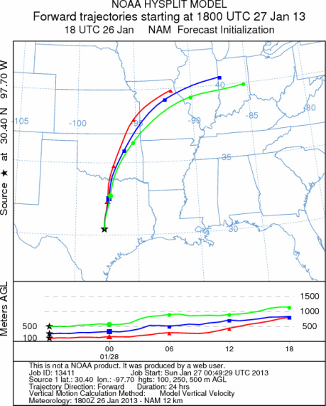
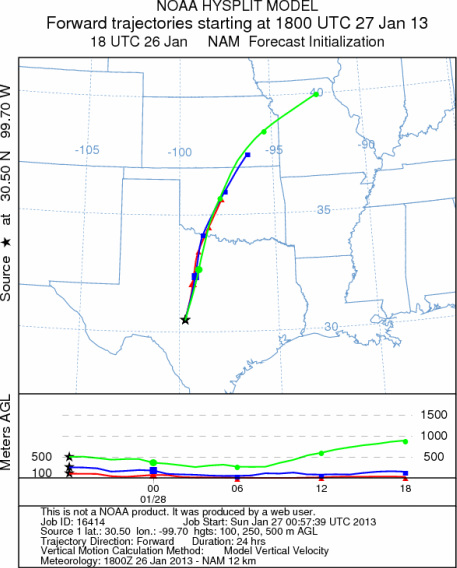
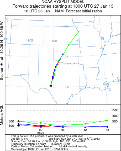
Trajectory Start (s) (shown by *
on map): Austin, TX; Junction, TX; Sonora, TX.
AUSTIN
JUNCTION
SONORA
EDWARDS PLATEAU COMPOSITE
Prepared by: Estelle
Levetin (Faculty of Biological
Science, The
University of Tulsa, 800 S. Tucker Dr., Tulsa, OK 74104) and ) and Peter
K Van de Water (Department of Earth and Environmental Science, California State University Fresno,
2576 East San Ramon Avenue, M/S ST24, Fresno CA 93740-8039). This forecast gives the anticipated future track of
released Mountain Cedar pollen, weather conditions over the region and along the forecast pathway, and an estimated
time of arrival for various metropolitan areas.
Questions: Aerobiology Lab e-mail: pollen@utulsa.edu
Return to Forecasting Home Page