
The University of Tulsa
Mountain Cedar Pollen Forecast
Metropolitan Area |
Exposure Risk |
|
Dallas/Fort Worth |
Moderate |
|
Austin |
Moderate |
|
San Antonio |
Moderate |
Date Issued: 28 January 2013
Mountain Cedar Location(s): Edwards Plateau, Texas
Regional Weather: Monday, January 28 TX/OK:
Across the region the weather will see a lot of moisture with mostly cloudy to cloudy skies beginning each day
over the forecast period. Patchy fog and drizzle is possible over all of Texas and southern Oklahoma today.
Showers and thunderstorms may build and the region as a whole has a 20% chance, except for the far western and
southwestern portion of the Edwards Plateau. Temperatures today will be in the 70s with the far western Edwards
Plateau toying with the low 80s. Winds will be lite to moderate from the south all day, then will diminish slightly
into the evening but maintaining a flow from the south overnight. In the evening showers and thunderstorms are
a potential with a 20% chance in most areas. The low temperatures will be in the 60s mostly, with mid to lower
50s to the north and across the Edwards Plateau. Tomorrow, the skies will remain cloudy to mostly cloudy across
the region except for partly sunny skies in San Antonio. The chance of thunderstorms and showers climbs with a
60% chance in the Dallas/Fort Worth area and 70% along the border with Oklahoma. In the edge communities and eastern
Edwards Plateua there will be a chance of showers and thunderstorms although in the 20% to 40% range. Temperatures
will climb once again into the 80s in the southernmost areas surrounding the Plateau. Winds will be from the
south and southwest starting at lite to moderate conditions but becoming very strong (35 to 45 mph) into the late
afternoon especially on the Edwards Plateau. The winds will remain mostly from the west and southwest. Tomorrow
night skies will begin to clear with a chance of showers everywhere but on the Edwards Plateau. Low temperatures
will cool significantly with the Edwards Plateau and in southern Oklahoma dropping into the mid 30s. From the
Dallas/Fort Worth area southward around the edge of the Plateau lows will remain in the mid 40s. Winds will remain
moderate with strong gusts as high as 35 mph in places.
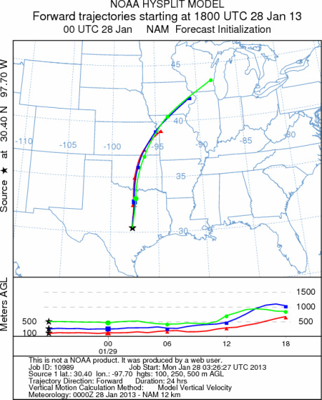
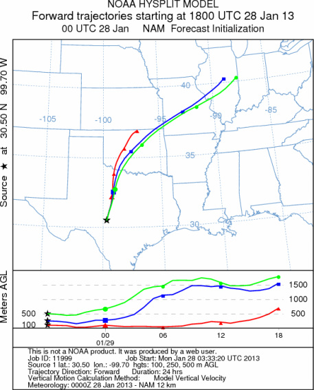
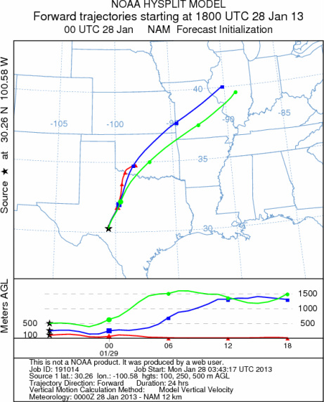
Trajectory weather: The air mass trajectories over the Arbuckle Mountains move to the north across Oklahoma
and onward into eastern Kansas and then over Missouri. The trajectories at ground level will be stable and move
along the ground to begin with as they travel downwind. Temperatures will be in the mid 70s to the low 80s across
Texas both today and tomorrow. In Oklahoma the temperatures will also be in the 70s today and tomorrow. Both
days, across the entire region there will be high levels of moisture resulting in early morning fog and drizzle
today. Later in the afternoon an increasing chance of showers and thunderstorms begin to develop. The chance
of Thunderstorms will continue overnight and into tomorrow and tomorrow night. Tomorrow will see the greatest
chance. Tomorrow the western portions of the Edwards Plateau will remain dry with most of the moisture in the
eastern Edwards Plateau and in the edge communities surrounding the Plateau. Winds will be from the south today
and tonight at lite to moderate conditions. Tomorrow the winds will begin to build to moderate conditions with
areas to the west and southwest experiencing very strong winds. Sonora TX during tomorrow afternoon may see gusts
to 45 miles per hour. Temperatures tomorrow will return to the warm conditions expected today. Tomorrow night,
however, cooler conditions will build in with lows in the 30s on the Plateau and in Oklahoma and 40s in the surrounding
communities.
OUTLOOK: *** Moderate Threat today and Moderate threat Tomorrow *** Warm conditions
today and tomorrow with high temperatures expected to be in the 70s to low 80s. Winds will be lite to moderate
across Texas and building to strong conditions in Oklahoma. The southerly flow will remain tonight, tomorrow and
tomorrow night. Cloudy skies will build over the region and moisture will result in patchy fog and drizzle in
areas surrounding the Edwards Plateau both days. The moisture will result in an increasing chance of showers through
the day today and into tomorrow and tomorrow night. Today and tonight the chance of precipitation will be region
wide and then decline to the eastern Edwards Plateau and surrounding communities tomorrow and tomorrow night.
Winds will be from the south shifting to the southwest and then west. Tomorrow moderate winds will increase in
the afternoon over the Edwards Plateau resulting in gusts in the evening approaching 45 miles per hour. The temperatures
will be good for pollen release but the amount of moisture, cloudy conditions and developing showers and thunderstorms
suggest that most pollen will be washed from the airstream. Any pollen that does get airborne will move northward
on the dominant wind pattern from the south today, tonight and tomorrow. We are in the middle of the historical
pollen season, this results in a better chance of pollen moving along the trajectory pathways both today and tomorrow.
However, high moisture levels and stormy conditions will dampen pollen entrainment and travel. For these reasons
a moderate chance of pollen moving northward from Texas is expected.
Trajectory Start (s) (shown by *
on map): Austin, TX; Junction, TX; Sonora, TX.
AUSTIN
JUNCTION
SONORA
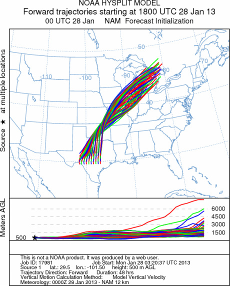
EDWARDS PLATEAU COMPOSITE
Prepared by: Estelle
Levetin (Faculty of Biological
Science, The
University of Tulsa, 800 S. Tucker Dr., Tulsa, OK 74104) and ) and Peter
K Van de Water (Department of Earth and Environmental Science, California State University Fresno,
2576 East San Ramon Avenue, M/S ST24, Fresno CA 93740-8039). This forecast gives the anticipated future track of
released Mountain Cedar pollen, weather conditions over the region and along the forecast pathway, and an estimated
time of arrival for various metropolitan areas.
Questions: Aerobiology Lab e-mail: pollen@utulsa.edu
Return to Forecasting Home Page