
The University of Tulsa
Mountain Cedar Pollen Forecast
Metropolitan Area |
Exposure Risk |
|
Dallas/Fort Worth |
Moderate |
|
Austin |
Moderate |
|
San Antonio |
Moderate |
Date Issued: 29 January 2013
Mountain Cedar Location(s): Edwards Plateau, Texas
Regional Weather: Tuesday, January 29 TX/OK:
Across the region the weather will see a lot of moisture with mostly cloudy to cloudy skies today then clearing
out tomorrow and tomorrow night. The air will be moist across Texas today with a significant chance of rain to
the north in Oklahoma stretching southward into the Dallas/Fort Worth area and then onto the communities surrounding
the eastern Edwards Plateau. There will be the chance of afternoon showers and thunderstorms throughout those
areas, but decrease towards the south. High temperatures will be warm with the upper 70s common and San Antonio
reaching into the 80s. The winds will be from the southwest at moderate levels to the north and starting at moderate
conditions to the south that will increase in the afternoon to strong conditions and gusts reaching 45 mph. Tonight
the skies will begin to clear with partly cloudy conditions in most areas. A few communities will continue to
have a chance of a shower or thunderstorm; however the overall chance across the region is not above 20% chance.
Tonights temperatures will be in the 30s to the north across Oklahoma, in the 40s from Dallas/Fort Worth along
the eastern rim of the Edwards Plateau, and back in the 30s on the Plateau itself. Winds will remain moderate
to strong from the west and northwest. Tomorrow sunny skies will return to the region with high temperatures ranging
from the 40s in Oklahoma to the 50s through the northern DFW metro region and into the 60s in the communities
surrounding the Edwards Plateau. Temperatures will climb inot the upper 50s on the Edwards Plateau. Winds will
be from the northwest at moderate conditions. Tomorrow night mostly clear conditions will dominate. Temperatures
will drop into the 30s from southern Oklahoma south through to the edge communities surrounding the Edwards Plateau.
On the Plateau temperatures will be in the upper 20s. Winds will be mixed with southwesterly breezes to the
north and on the Plateau. Winds will begin from the northwest elsewhere but then turn during the night to a more
southwesterly flow. Winds will be lite overnight
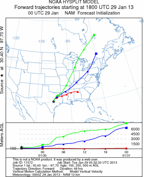
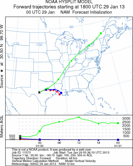
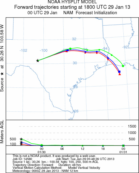
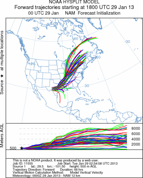
Trajectory weather: The air mass trajectories over the Edwards Plateau move to the northeast over Arkansas
and onward into the Mississippi and Ohio River Valleys. The trajectories at ground level will be very buoyant
and the chance of thunderstorms and showers are at 80% for the Arbuckle region. In Texas the high temperatures
will be in the mid to upper 70s pushing the 80 degree mark in San Antonio. However, a significant cool down
is expected tomorrow and high temperatures returning to the upper 50s and low 60s. Today, later in the afternoon
an increasing chance of showers and thunderstorms will begin to develop across the northern area. The chance of
Thunderstorms will begin to clear overnight with no chance of precipitation tonight and into tomorrow as well as
tomorrow night. Colder air will move into the region and tomorrow along with tomorrow night will see a significant
cool down. Low temperatures tomorrow night will be in the upper 20s to low 30s.
OUTLOOK: *** Moderate Threat today and Moderate Threat tomorrow *** The last of
the warm conditions will occur today with much cooler conditions tomorrow. Today Temperatures will build to the
mid 70s in most regions with areas along the southern margin of the Edwards Plateau potentially reaching 80.
Winds will be moderate to strong across Texas and building towards very strong conditions in the late afternoon.
The southwesterly flow will remain today, then switch to a more westerly flow tonight. Tomorrow winds will be
from the northwest and tomorrow night areas begin to switch back to a southwesterly flow from the northwesterly
conditions tomorrow. Cloudy skies will remain today with a significant chance of rain in southern Oklahoma southward
along the eastern side of the Edwards Plateau. The temperatures will be good for pollen release but the amount
of moisture, cloudy conditions and developing showers and thunderstorms to the north suggests that most pollen
will be washed from the airstream as it moves to the north. Any pollen that does get airborne will move northward
on the dominant wind pattern from the south, heading into unsettle conditions to the north. We are in the middle
of the historical pollen season, this results in a better chance of pollen moving along the trajectory pathways
however expected showers and thunderstorms will wash much of it out of the air stream .
Trajectory Start (s) (shown by *
on map): Austin, TX; Junction, TX; Sonora, TX.
AUSTIN
JUNCTION
SONORA
EDWARDS PLATEAU COMPOSITE
Prepared by: Estelle
Levetin (Faculty of Biological
Science, The
University of Tulsa, 800 S. Tucker Dr., Tulsa, OK 74104) and ) and Peter
K Van de Water (Department of Earth and Environmental Science, California State University Fresno,
2576 East San Ramon Avenue, M/S ST24, Fresno CA 93740-8039). This forecast gives the anticipated future track of
released Mountain Cedar pollen, weather conditions over the region and along the forecast pathway, and an estimated
time of arrival for various metropolitan areas.
Questions: Aerobiology Lab e-mail: pollen@utulsa.edu
Return to Forecasting Home Page