
The University of Tulsa
Mountain Cedar Pollen Forecast
Metropolitan Area |
Exposure Risk |
|
Dallas/Fort Worth |
Moderate |
|
Austin |
Moderate |
|
San Antonio |
Moderate |
Date Issued: 30 January 2013
Mountain Cedar Location(s): Edwards Plateau, Texas
Regional Weather: Tuesday, January 30 TX/OK:
Across the region the weather will settle back into sunny skies and more moderate temperatures. Today mostly sunny
to sunny skies will dominate the region with temperatures in the 50s in all areas except for the edge communities
surrounding the Edwards Plateau. Winds will be from the Northwest today starting at strong conditions decreasing
to moderate levels. Tonight mostly clear to clear skies will allow temperatures to drop. The Edwards Plateau
will drop into the upper 20s and the remainder of the area will stay above freezing mostly in the mid 30s. Winds
will slacken to lite conditions and turn away from the northwest coming from the southwest by morning. Tomorrow
mostly sunny and sunny conditions will return with the entire region returning to the mid-60s except for the far
north in central Oklahoma. Winds will be from the southwest at lite to moderate levels. The Arbuckle Mountains
will more of a westerly flow. Tomorrow night mostly clear skies across the region will result in a cool evening.
The entire region, except in central Oklahoma, will be in the low 30s to just dipping under 40 degrees in the
edge communities. Winds will be from the north and northeast in Oklahoma at lite to moderate levels. Southward
in Texas lite winds will be mostly from the southwest in the edge communities and a general southerly flow will
occur over the Edwards Plateau.
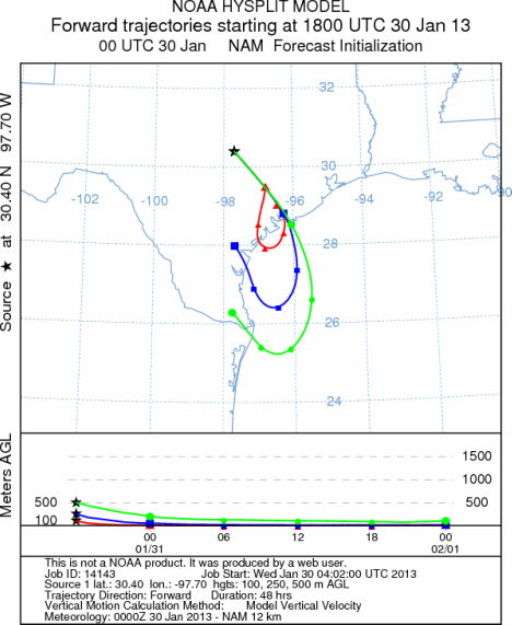
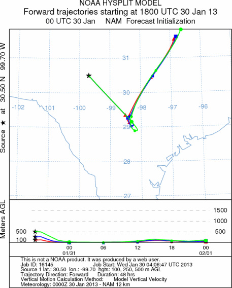
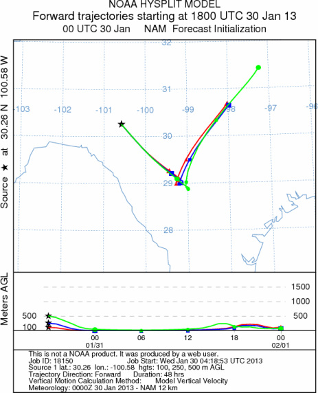
Trajectory weather: The air mass trajectories over the Edwards Plateau move to the southeast over southeastern
Texas and then turn back towards the Edwards Plateau as the winds back coming from the southwest tomorrow. The
air will be cool and dense travelling at ground level. High temperatures today will be in the upper 50s and low
60s a significant cooling from the last couple of days. The trajectories swirl over southern and southern central
Texas. Today, winds will initially be strong, upwards of 25 miles per hour sustained, with gusts in the 35 mph
range. Low temperatures tonight will be in the upper 20s to low 30s and winds will relax to low levels turning
from their northwest direction, coming from the southwest. Tomorrow clear to mostly clear skies return for another
day. Temperatures increase into the mid to upper 60s and winds will remain from the southwest at moderate conditions.
Tomorrow night mostly clear skies will remain with temperatures 5 to 10 degrees warmer than tonight. Most areas
will remain above freezing. Winds will remain calm mostly from the southwest.
OUTLOOK: *** Moderate to Severe Threat today and Severe threat Tomorrow
*** Conditions for pollen release are good today but the air is dense but it will be very breezy. For these
reason pollen will be released and entrained but downwind travel will be restricted by the wind density and its
movement at or near the ground. Conditions today will push any entrained pollen into the southern portion of the
state on a dominant northwesterly wind pattern. Temperatures will cool with most highs in the 50s to low 60s.
Winds will be strong from the northwest as the cold front pushes across the region. Tomorrow a southwesterly
wind takes over at moderate conditions. Temperatures will warm into the upper 60s in most areas. Any pollen
that gets airborne today will move southward. The air is very dense and thus most of the pollen will be cleared
from the air by impaction on surfaces at or near the ground. Pollen that does get entrained may be able to move
some distance. Areas to the southeast and south along the Gulf Coast (McAllen, to Corpus Christie, to Houston
and Galveston) will see pollen that is entrained today. Tomorrow the winds will shift to a southwesterly flow
and thus any pollen entrained will move northward.
Trajectory Start (s) (shown by *
on map): Austin, TX; Junction, TX; Sonora, TX.
AUSTIN
JUNCTION
SONORA
EDWARDS PLATEAU COMPOSITE
Prepared by: Estelle
Levetin (Faculty of Biological
Science, The
University of Tulsa, 800 S. Tucker Dr., Tulsa, OK 74104) and ) and Peter
K Van de Water (Department of Earth and Environmental Science, California State University Fresno,
2576 East San Ramon Avenue, M/S ST24, Fresno CA 93740-8039). This forecast gives the anticipated future track of
released Mountain Cedar pollen, weather conditions over the region and along the forecast pathway, and an estimated
time of arrival for various metropolitan areas.
Questions: Aerobiology Lab e-mail: pollen@utulsa.edu
Return to Forecasting Home Page