The University of Tulsa
Mountain Cedar Pollen Forecast

Metropolitan Area |
Exposure Risk |
|
Oklahoma City |
Moderate |
|
Tulsa |
Low |
|
St. Louis MO |
Low |
Date Issued: 31 January 2013
Mountain Cedar Location(s): Arbuckle Mountains, OK
Regional Weather: Thursday, January 31 TX/OK:
Across the region the weather will continue with sunny skies and more moderate temperatures. Today mostly sunny
to sunny skies will dominate the region with temperatures in the 60s in all areas except far to the north in central
Oklahoma.. Winds will be from the Southwest today at moderate strengths. Tonight mostly clear to clear skies
will allow temperatures to drop into the 20s to the north in Oklahoma and in the lower 30s on the Edwards Plateau.
In the edge communities the upper 30s will be prevalent. Winds will be from the south at lite conditions over
the Edwards Plateau. In the edge communities winds will be lite and from the southeast along the southern edge
and the southwest in Austin and further north. The Dallas/Fort Worth area will see winds from the northwest turning
to the northeast. In Oklahoma a northeasterly flow will occur at lite levels. Tomorrow mostly sunny skies with
partly cloudy conditions build over the Edwards Plateau during the day. High temperatures will be in the upper
60s over most of Texas. In Oklahoma the highs will be in the mid 50s. Winds in Oklahoma will be from the southeast
at lite to moderate conditions. Across the Edwards Plateau in Texas winds will be stronger at moderate to strong
conditions from the south. Winds in those areas will build during the afternoon. In the edge communities winds
will start very lite from the east then switch to the southeasterly flow at moderate conditions. Tomorrow night
partly cloudy to cloudy conditions will return across Texas. Low temperatures will be mild, 40s and 50s, and
winds will be moderate from the south.
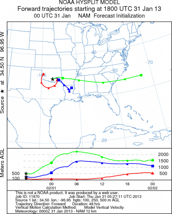
Trajectory weather: The air mass trajectories over the Arbuckle Mountains move in a clockwise fashion at
ground level circling the area of release over the next 48 hours. Sunny skies and high temperatures in the low
60s dropping to the low 50s tomorrow. The ground winds traverse around the population in a clockwise direction
while those trajectories started at 250m and at 500m will remain on a east southeasterly pathway. The air is very
dense with the influx of cold conditions from the north. Tomorrow clear and mostly sunny skies return for another
day. Temperatures cool into the mid 50s with winds from the southeast at lite to moderate conditions. and winds
will rotate to a westerly direction at lite levels. Tomorrow night mostly clear skies will remain with temperatures
returning to the mid to low 20s. Winds will be moderate from the northeast.
OUTLOOK: *** Moderate Threat today and Moderate threat Tomorrow *** Conditions
for pollen release are moderate today with high temperatures only in the low 60s and cooling into the mid 50s
tomorrow. In addition the air is dense and it will be lite wind conditions today and moderate winds tomorrow.
For these reason pollen will be released and entrained but downwind travel will be restricted by the wind density
and its movement at or near the ground. Conditions today will move any entrained pollen at or near the ground
surface. Tomorrow temperatures will cool with highs in the mid 50s. Winds will be moderate from the southeast.
Trajectory Start (s) (shown by black
star on map): Davis, OK.
Prepared by: Estelle
Levetin
(Faculty
of Biological Science, The University of Tulsa, 800 S. Tucker Dr., Tulsa, OK 74104) and Peter
K Van de Water
(Department of Earth and Environmental Science, California State University Fresno, 2576 East San Ramon Avenue,
M/S ST24, Fresno CA 93740-8039). This forecast gives the anticipated future track of released Mountain Cedar pollen,
weather conditions over the region and along the forecast pathway, and an estimated time of arrival for various
metropolitan areas.
Questions: Aerobiology Lab e-mail: pollen@utulsa.edu
Return to Forecasting Home Page