The University of Tulsa
Mountain Cedar Pollen Forecast

Metropolitan Area |
Exposure Risk |
|
Oklahoma City |
Low |
|
Tulsa |
Low |
|
St. Louis MO |
Low |
Date Issued: 2 February 2013
Mountain Cedar Location(s): Arbuckle Mountains, OK
Regional Weather: Saturday, February 2 TX/OK:
Across the region the weather will continue mild with moderate to warm temperatures. Today sunny skies will dominate
the region with temperatures in the 60s to mid-70s. In the morning, patchy foggy will occur during the morning
hours in the edge communities. As the area warms, winds will be mostly from the north in the morning with some
of the edge communities having a more southerly flow. By tonight, a more north to northeasterly flow will dominate
the entire region. Tonight the low temperatures will be in the mid to upper 30s to the north in Oklahoma and
across the Edwards Plateau. The edge communities will remain mild with lows in the mid 40s to low 50s. Winds
will remain at lite to moderate levels from the north and northeast. Tomorrow skies to the north will be sunny
with increasing clouds towards the south. High temperatures will be in the upper 60s across the region, except
towards the Oklahoma border where temperatures will cool to the upper 50s. Tomorrow winds will begin from the
north and northeast, then shift towards the southeast and eventually to the south. Across the Edwards Plateau
winds will build towards strong conditions during the afternoon. Tomorrow night low temperatures will be in the
40s in most areas with warmer conditions in the surrounding edge communities. The edge communities will also see
patchy fog and the potential of drizzle building in. Winds will once again be primarily from the south and southeast
at lite levels, but bringing warm moist air up from the Gulf of Mexico.
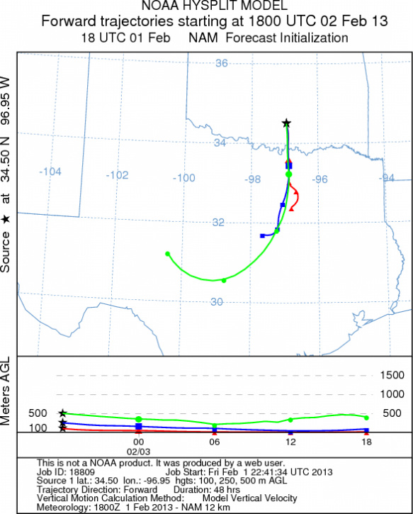
Trajectory weather: The air mass trajectories over the Arbuckle Mountains, shows cold dense air in the atmosphere
move pollen southward on a dominant north wind. Temperatures will reach into the low 60s today and mid 60s tomorrow.
Warm conditions should release pollen but the dense character of the atmosphere suggests that much of the pollen
will be removed upon travel by impaction against other vegetation. The trajectories move the pollen towards the
south, on northerly winds tonight, then will eventually switch back tomorrow as southerly winds regain their strength.
OUTLOOK: *** Low Threat today and Moderate threat Tomorrow
*** Conditions for pollen release are low today with moderate temperatures in the low 60s, warming into the
mid 60s tomorrow. Today the air is dense with the northerly flow and thus stays very close to the ground where
impaction can occur. Winds will be lite today, building into tomorrow. For these reason pollen is expected to
be released and entrained with downwind travel, but at ground level where impaction is a primary remover of pollen
from the airstream. Tomorrow winds will pick up but the wind will be coming from the south and potentially will
impact communities to the north.
Trajectory Start (s) (shown by black
star on map): Davis, OK.
Prepared by: Estelle
Levetin
(Faculty
of Biological Science, The University of Tulsa, 800 S. Tucker Dr., Tulsa, OK 74104) and Peter
K Van de Water
(Department of Earth and Environmental Science, California State University Fresno, 2576 East San Ramon Avenue,
M/S ST24, Fresno CA 93740-8039). This forecast gives the anticipated future track of released Mountain Cedar pollen,
weather conditions over the region and along the forecast pathway, and an estimated time of arrival for various
metropolitan areas.
Questions: Aerobiology Lab e-mail: pollen@utulsa.edu
Return to Forecasting Home Page