
The University of Tulsa
Mountain Cedar Pollen Forecast
Metropolitan Area |
Exposure Risk |
|
Dallas/Fort Worth |
Moderate |
|
Austin |
Moderate |
|
San Antonio |
Moderate |
Date Issued: 6 February 2013
Mountain Cedar Location(s): Edwards Plateau, Texas
Regional Weather: Wednesday, February 6 TX/OK: Across
the region, a chance of rain will build in with a chance of thunderstorms and showers with mostly cloudy to cloudy
skies. To the north in southern Oklahoma the chance of precipitation is 20% which builds to more than 60% in the
communities surrounding the Edwards Plateau. On the Plateau the chance of rain will be between 20% and 30%. The
rain will occur as showers and thunderstorms that will move across the region once initiated. High temperatures
are expected to be in the upper 60s in most areas to the north and in the lower 70s on the Plateau and extending
to the southern edge communities, such as San Antonio. Winds will be from the southeast across most of the region
but will turn more from the south in the western portions of the Edwards Plateau. Tonight similar conditions with
the chance for precipitation will remain, although the chance will decline. Rain will once again be in the form
of showers and thunderstorms. Low temperatures across the region wil be in the mid to upper 50s in most areas
except for the Edwards Plateau were temperatures in the upper 40s will prevail. Winds will remain mostly from
the south and southeast. Tomorrow conditions begin to improve with the chance of rain remaining from the Dallas/Fort
Worth metro region to the north into southern Oklahoma. In the surrounding communities patchy morning fog will
occur in the edge communities. Winds tomorrow will shift coming mostly from the west in the central and southern
Texas region. Along the border winds will remain from the south. Tomorrow night partly cloudy skies will result
in low temperatures in the upper 40s to low 50s. Winds will rotate, coming from the north at lite to moderate
conditions.
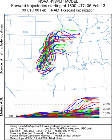
Trajectory weather: The air mass trajectories over the Edwards Plateau are mixed initially with areas in
the southern edge areas of the plateau moving to the southwest. At the same time the remaining areas show the
trajectories moving into western and northern areas of Texas, eventually travelling into western Oklahoma. Today
there will be a building chance of both showers and thunderstorms that will wash any entrained pollen from the
atmosphere. Temperatures will be warm, upper 60s and low 70s. Winds will remain at lite to moderate levels.
Tomorrow the chance of precipitation will decrease except in the border region with Oklahoma. Temperatures will
remain at about the same warmth and winds will switch to a more west to east flow. Tomorrow night temperatures
cool off with most readings in the mid to low 40s. The edge communities will be 5 to 8 degrees warmer. Winds
will remain from the north to northwest at lite to moderate levels.
OUTLOOK: *** Moderate Threat Today and Moderate Threat Tomorrow *** Conditions
for pollen release are good today with winds that will be moderate from the east and southeast and temperatures
will be warm in the 70s. Trajectories across the Edwards Plateau show a mixed atmosphere that eventually moves
northward for most of the area, however along the southern edge communities winds move towards the southwest.
A chance of rain across the entire region will begin to build today. The precipitation will occur as showers
and thunderstorms. Where they occur expect any pollen in the atmosphere will be washed out. Tomorrow the area
will begin to dry out with warm conditions and westerly winds. Tomorrow night the area will be partly cloudy with
low temperatures cooling on moderate breezes from the north and northwest.
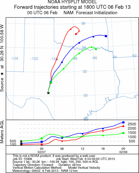
Trajectory Start (s) (shown by *
on map): Austin, TX; Junction, TX; Sonora, TX.
AUSTIN
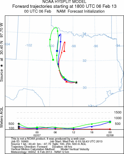
JUNCTION

SONORA
EDWARDS PLATEAU COMPOSITE
Prepared by: Estelle
Levetin (Faculty of Biological
Science, The
University of Tulsa, 800 S. Tucker Dr., Tulsa, OK 74104) and ) and Peter
K Van de Water (Department of Earth and Environmental Science, California State University Fresno,
2576 East San Ramon Avenue, M/S ST24, Fresno CA 93740-8039). This forecast gives the anticipated future track of
released Mountain Cedar pollen, weather conditions over the region and along the forecast pathway, and an estimated
time of arrival for various metropolitan areas.
Questions: Aerobiology Lab e-mail: pollen@utulsa.edu
Return to Forecasting Home Page