
The University of Tulsa
Mountain Cedar Pollen Forecast
Metropolitan Area |
Exposure Risk |
|
Dallas/Fort Worth |
Moderate |
|
Austin |
Moderate |
|
San Antonio |
Moderate |
Date Issued: 7 February 2013
Mountain Cedar Location(s): Edwards Plateau, Texas
Regional Weather: Thursday, February 7 TX/OK: Across
the region cloudy conditions will occur after rain has moved through overnight. To the north today, in Oklahoma
and the border region with Texas the chance of showers and thunderstorms will continue into the daylight hours.
To the south conditions will be partly cloudy. Temperatures will return into the low 60s in the Arbuckle Mountains
rising to the 70s across Texas. The edge communities will warm to the upper 70s whereas the Plateau will be
in the mid to upper 70s. Across the northern region south to southwesterly flow will switch over to a more northerly
flow with the weather system moving through the area. Further south in the edge communities winds will primarily
be from the south and southwest although San Antonio will begin with a northerly flow then switch during the day.
On the Plateau winds will be from the west and northwest in the western portion around San Angelo. Tonight partly
cloudy conditions will remain across Texas and mostly cloudy skies to the north. A 20% chance of precipitation
will remain in the Arbuckle Mountain area. Low temperatures overnight will be in the 40s across the Texas region.
In Oklahoma the lows will drop into the upper 30s along the border. Winds will be lite to moderate from the
north. Tomorrow skies will begin to clear although a bit cooler than today. High temperatures across Texas will
drop into the upper 60s in most areas. The edge communities will remain in the 70s. Winds will remain at lite
to moderate conditions from the north and northeast. Tomorrow night skies will begin to cloud up once again.
Partly cloudy conditions will build to the north with lows in the low 40s and upper 30s in Oklahoma. Across
Texas the lows will fall into the lower 50s in the edge communities and in the mid to upper 40s across the Edwards
Plateau. Winds that have been from the north for the last day or so will switch coming from the east in the edge
communities and from the southeast on the Edwards Plateau and in southern Oklahoma.
Trajectory weather: The air mass trajectories over the Edwards Plateau move southward and to the southeast
on north to northwesterly winds. Overnight the general northwesterly winds will move to a primary north to south
flow moving the trajectories almost due south. Tomorrow the winds drift toward the east resulting in northeasterly
flow across the region. Temperatures will be warm today with most areas recording in the 70s. A chance of precipitation
remains this morning to the north in Oklahoma. Tonight skies begin to thin with much of Texas having partly cloudy
conditions. Low temperatures will be mild in the edge communities but seasonal across the Edwards Plateau and
northward into Oklahoma. Tomorrow the sun returns with partly sunny to mostly sunny skies. On the Plateau mostly
cloudy conditions will remain. Temperatures will be cooler by five to ten degrees. Winds will remain lite to
moderate from the north and northeast. Tomorrow night cloudy conditions build in once again with lows temperatures
remaining mild. Across Texas lows will be in the 40s except along the edge communities where the lower 50s
will be prevalent.
OUTLOOK: *** Moderate Threat today and Moderate threat Tomorrow *** Conditions
for pollen release are good today with winds that will be moderate from the north temperatures will be warm in
the 70s. The air will be buoyant and somewhat mixed across the Edwards Plateau. Trajectories across the Edwards
Plateau show a mixed atmosphere that eventually moves both southeastward as well as southward. A chance of rain
will remain to the north in southern Oklahoma and northern most Texas along the Oklahoma border. Tomorrow the
area will begin to brighten with mostly sunny skies except on the Plateau where partly cloudy conditions are expected.
Temperatures tomorrow will once again be warm with highs in the mid to low 70s and upper 60s. There is increasing
evidence that other trees are beginning to pollinate and the overall load of Juniper pollen is declining. We are
beginning to see the end of this years Ash Juniper pollination season.
Trajectory Start (s) (shown by *
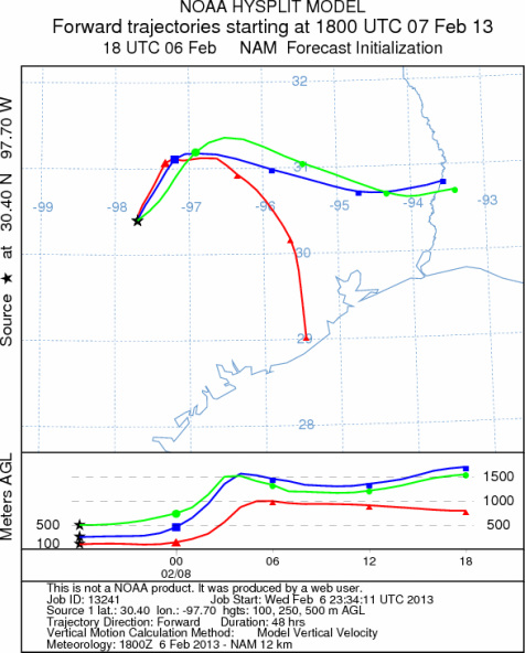
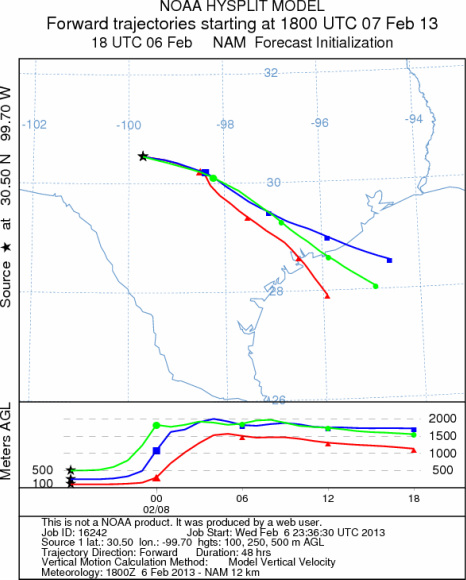
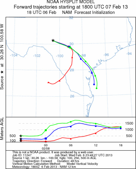
on map): Austin, TX; Junction, TX; Sonora, TX.
AUSTIN
JUNCTION
SONORA
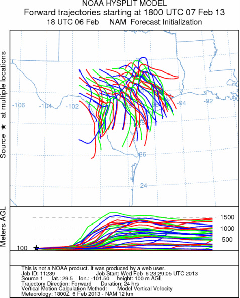
EDWARDS PLATEAU COMPOSITE
Prepared by: Estelle
Levetin (Faculty of Biological
Science, The
University of Tulsa, 800 S. Tucker Dr., Tulsa, OK 74104) and ) and Peter
K Van de Water (Department of Earth and Environmental Science, California State University Fresno,
2576 East San Ramon Avenue, M/S ST24, Fresno CA 93740-8039). This forecast gives the anticipated future track of
released Mountain Cedar pollen, weather conditions over the region and along the forecast pathway, and an estimated
time of arrival for various metropolitan areas.
Questions: Aerobiology Lab e-mail: pollen@utulsa.edu
Return to Forecasting Home Page