The University of Tulsa
Mountain Cedar Pollen Forecast

Metropolitan Area |
Exposure Risk |
|
Oklahoma City |
Moderate |
|
Tulsa |
Moderate |
|
St. Louis MO |
Low |
Date Issued: 4 January 2014
Mountain Cedar Location(s): Arbuckle Mountains, OK
Regional Weather: Saturday/ Sunday, January 4/5 TX/OK:
Across the region today the weather will be mild with warm conditions, partly cloudy skies today building toward
mostly sunny conditions tomorrow. Today high temperatures are expected to be in the mid- to upper 60s across
Texas with temperatures in the mid- 50s to the north in southern portion of Oklahoma. Temperatures are expected
to reach the mid-40s in central Oklahoma. Winds will be moderate to strong from the south and southwest. Overnight
a significant change will occur as cold air drops southward cooling the area significantly tomorrow. Tonight the
Texas region will have partly cloudy skies with lows in the lower 30s to mid-20s. In the communities surrounding
the Edwards Plateau temperatures will remain in the upper 30s to 40 degrees. Winds will begin to switch from todays
south to southwesterly direction coming from the north to northwest. The air mass that flows southward is cold
and dense, thus it will push into the region at low levels. As this occurs winds will be light to moderate with
most areas in the 10 to 20 mph range. With the colder air, tomorrows skies will be mostly sunny. The western
Edwards Plateau will begin partly cloudy but will clear as the day progresses. High temperatures on Sunday will
be mostly in the 30s with the southernmost communities in the low 40s on the Edwards Plateau and upper 40s in
the surrounding communities. Winds will stabilize blowing from the north across the region. Wind gusts as great
as 30 mph are expected in the areas surrounding the Edwards Plateau where canyons drain air off of the higher elevations.
Wind chill is expected to be significant. Tomorrow night temperatures across the region will be in the single
digits in Oklahoma whereas across central Texas lows in the teens are expected.
Trajectory weather: Air mass trajectories over Oklahoma move initially northeastward on moderate to strong
southwesterly winds today. Winds will be locally gusty, especially in each region as the direction of wind changes
with the encroachment of cold air from the north. Temperatures will be in the mid- 40s in central Oklahoma and
mid-50s towards the border region. Skies will be partly cloudy today building to mostly cloudy conditions tonight.
Tonight temperatures will fall into the teens as cold northern air moves southward. There will be a 20% chance
of snow occurring in the central Oklahoma region. Winds will be maintained at moderate levels form the north.
Tomorrow partly cloudy skies across central Oklahoma will give way to sunny skies along the borderlands and into
Texas. High temperatures will be in the lower 20s to low 30s from north to south. Winds will remain from the
north at moderate levels. Tomorrow night conditions will be frigid with lows in the single digits. Winds will
remain from the north at low to moderate winds speeds.
OUTLOOK: *** Moderate Threat Today and Low Threat Tomorrow
*** Good conditions for pollen release today in the Arbuckle populations with highs in the mid 50s. Conditions
will deteriorate as the weather changes from warm to cold with the switch in wind direction from the south to a
northerly direction. Today temperatures in the mid 50s with partly cloudy conditions will promote pollen release.
Conditions for entrainment and travel will be moderate with moderate to strong winds including gusts of 25 to
30 mph. The dense air as it moves in will keep entrained pollen near the surface where impaction and settling
occur. As the air masses change, this afternoon and tonight, very cold air will drop southward across the region.
Tomorrow conditions will deteriorate significantly as cold air from the north moves across the region. The change
will begin from the north and west and progress south and eastward. Highs tomorrow will be in the low 20s to low
30s along the border with Texas. The cold conditions should restrict any pollen release on Sunday.
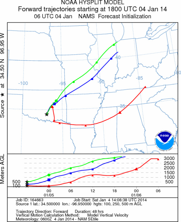
Trajectory Start (s) (shown by black
star on map): Davis, OK.
Prepared by: Estelle
Levetin
(Faculty
of Biological Science, The University of Tulsa, 800 S. Tucker Dr., Tulsa, OK 74104) and Peter
K Van de Water
(Department of Earth and Environmental Science, California State University Fresno, 2576 East San Ramon Avenue,
M/S ST24, Fresno CA 93740-8039). This forecast gives the anticipated future track of released Mountain Cedar pollen,
weather conditions over the region and along the forecast pathway, and an estimated time of arrival for various
metropolitan areas.
Questions: Aerobiology Lab e-mail: pollen@utulsa.edu
Return to Forecasting Home Page