
The University of Tulsa
Mountain Cedar Pollen Forecast
Metropolitan Area |
Exposure Risk |
|
Dallas/Fort Worth |
Moderate |
|
Austin |
High |
|
San Antonio |
High |
Date Issued: 4 January 2014
Mountain Cedar Location(s): Edwards Plateau, Texas
Regional Weather: Saturday/ Sunday, January 4/5 TX/OK:
Across the region today the weather will be mild with warm conditions, partly cloudy skies today building toward
mostly sunny conditions tomorrow. Today high temperatures are expected to be in the mid- to upper 60s across
Texas with temperatures in the mid- 50s to the north in southern portion of Oklahoma. Temperatures are expected
to reach the mid-40s in central Oklahoma. Winds will be moderate to strong from the south and southwest. Overnight
a significant change will occur as cold air drops southward cooling the area significantly tomorrow. Tonight the
Texas region will have partly cloudy skies with lows in the lower 30s to mid-20s. In the communities surrounding
the Edwards Plateau temperatures will remain in the upper 30s to 40 degrees. Winds will begin to switch from the
days south to southwesterly direction coming from the north to northwest. The air mass that flows southward is
cold and dense, thus it will push into the region at low levels. As this occurs winds will be light to moderate
with most areas in the 10 to 20 mph range. With the colder air, tomorrow will be mostly sunny. The western Edwards
Plateau will begin partly cloudy but will clear as the day progresses. High temperatures on Sunday will be mostly
in the 30s with the southernmost communities in the low 40s on the Edwards Plateau and upper 40s in the surrounding
communities. Winds will stabilize blowing from the north across the region. Wind gusts as great as 30 mph are
expected in the areas surrounding the Edwards Plateau where canyons drain air off of the higher elevations. Wind
chill is expected to be significant. Tomorrow night temperatures across the region will be in the single digits
in Oklahoma whereas across central Texas lows in the teens are expected.
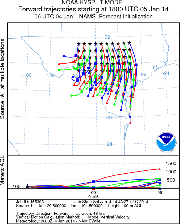
Trajectory weather: Air mass trajectories over Texas move initially northward on moderate to strong southerly
winds today. Winds will be locally gusty, especially in the regions surrounding the Edwards Plateau. Temperatures
will be in the mid- to upper 60s. Skies will be partly cloudy with greater sun breaks north of the Edwards Plateau
and in the immediate surrounding communities, especially along the eastern edge. San Antonio will begin mostly
cloudy but will clear during the afternoon. The winds will begin to switch this afternoon with the western Edwards
Plateau shifting first to a more westerly flow, then tonight the winds will turn coming out of the northwest and
eventually from the north. Overnight temperatures will be at or just below freezing on the Edwards Plateau. Warmer
conditions, 30s and 40s, will occur over the rest of Texas. Tomorrow the winds from the north will become entrenched
with high temperatures dropping some 20 to 30 degrees from today. San Antonio will struggle to get to 50 with
the rest of the region reaching only the 30s and 40s. Winds will remain moderate to strong with areas experiencing
gusts upwards of 30 mph. Tomorrow night the area temperatures will drop below 20 across the region. Winds will
lighten to moderate conditions, but wind chill will be life threatening for unprotected people, pets and plants.
OUTLOOK: *** High Threat Today and Low Threat Tomorrow
*** Excellent conditions for pollen release today in the Texas populations as the weather changes from warm
to cold. Today temperatures in the 60s with partly cloudy conditions but with a warm atmosphere will promote pollen
release. Conditions for entrainment and travel will be good with moderate to strong winds and strong gusts as
the air masses change tonight and tomorrow. These conditions will provide about best conditions for pollen entrainment
and travel yet seen this year during today. Tomorrow conditions will deteriorate significantly as cold air from
the north moves into the region. The change will begin from the west and progress across the region towards the
east. Highs tomorrow will be in the low 40s to upper 30s in most of the dense tree population areas. Wind speeds
will be modeate with gusts reaching into the upper 20 to 30 mph range. With the dominant northerly winds any pollen
that does get entrained will travel southward.
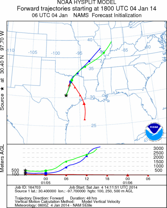
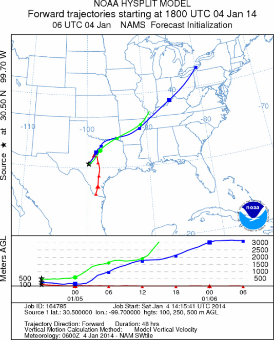
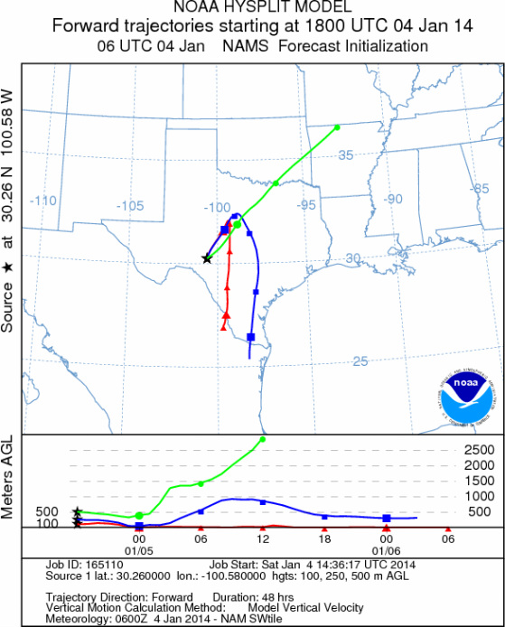
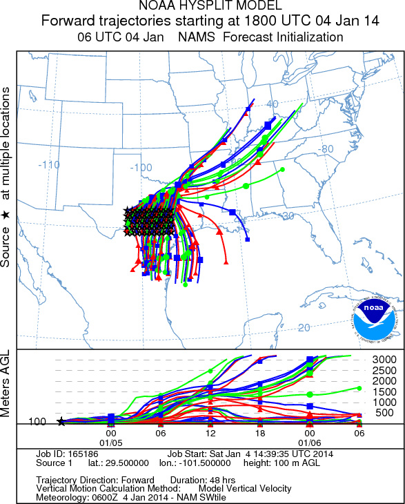
Trajectory Start (s) (shown by *
on map): Austin, TX; Junction, TX; Sonora, TX.
AUSTIN
JUNCTION
SONORA
EDWARDS PLATEAU COMPOSITE
Saturday - Jan 4
Sunday - Jan 5
Prepared by: Estelle
Levetin (Faculty of Biological
Science, The
University of Tulsa, 800 S. Tucker Dr., Tulsa, OK 74104) and ) and Peter
K Van de Water (Department of Earth and Environmental Science, California State University Fresno,
2576 East San Ramon Avenue, M/S ST24, Fresno CA 93740-8039). This forecast gives the anticipated future track of
released Mountain Cedar pollen, weather conditions over the region and along the forecast pathway, and an estimated
time of arrival for various metropolitan areas.
Questions: Aerobiology Lab e-mail: pollen@utulsa.edu
Return to Forecasting Home Page