
The University of Tulsa
Mountain Cedar Pollen Forecast
Metropolitan Area |
Exposure Risk |
|
Dallas/Fort Worth |
Low |
|
Austin |
Moderate |
|
San Antonio |
Moderate |
Date Issued: 7 January 2014
Mountain Cedar Location(s): Edwards Plateau, Texas
Regional Weather: Tuesday, January 7 TX/OK:
The region, Oklahoma through Texas, will be climbing out of the coldest conditions of the season today. Overnight
low temperatures have been well into the lower 20s and teens. This included communities surrounding the Edwards
Plateau and southward. Today sunny skies will let some warming begin as southerly winds will begin to push the
cold air out and warmer conditions into the area. Across Texas the highs will strive to just get into the mid-40s
on southerly winds that will be light to moderate. With the greater humidity moving northwards from the southerly
winds tonight the area will see more moderate conditions but with clouds building in the areas surrounding and
over the eastern portion of the Plateau region. There will be a chance of drizzle and/or patchy fog in the surrounding
communities tonight. To the west partly cloudy skies will dominate. Tomorrow, the clouds will continue across
the eastern portion of the Edwards Plateau with a 20% to 40% chance of drizzle and light rain in the surrounding
communities as well as northward towards Dallas and into Oklahoma. Temperatures across the Plateau will be in
the upper 50s and in the low 60s in the surrounding communities. The chance of precipitation in these areas will
continue into the evening. The dominant wind pattern will be moderate winds coming from the south, during the
day and into the evening. Mostly cloudy conditions will remain and a slight chance of rain remains to the east
and north in the edge communities to the Dallas/Ft. Worth area and into Oklahoma. Temperatures overnight will
remain mild with lows in the mid to low 30s across the Plateau and in the 40s to low 50s in the edge communities,
cooling to the north. The Oklahoma border region will be in the mid-30s and 20s in central portions of the state.
Trajectory weather: Air mass trajectories over Texas move northward on a steady southerly flow over the
next day and show some signs of curving back around tomorrow night when winds will begin to shift, towards Thursday.
Very cold air over the United States has brought cold dense air to the region and it will take a day or two to
flush most of it out of the area. Temperatures last night were very cold, and while sunny skies will dominate
and warmer southerly winds will start the warming process the warm up will take most of today and tonight, into
tomorrow. High temperatures tomorrow are expected to be back into the upper 50s and 60s. It is not expected that
conditions today will be very conducive for pollen release as the trees need some time to warm. If any pollen
is shed it would be this afternoon after some warm-up and tomorrow as conditions return into the upper 50s and
60s. Tonight and tomorrow in the communities surrounding the Edwards Plateau the southerly winds will bring moisture
northward with a 20% to 30% chance of rain tomorrow and tomorrow night.
OUTLOOK: *** Moderate Threat Today and Moderate to High Threat Tomorrow
*** Poor to moderate conditions for pollen release today in the Texas populations as very cold conditions
occurred overnight across the Plateau. Todays warming will keep high temperatures in the mid 40s after a cold
start. Temperatures will rebound tomorrow into the 50s and 60s resulting in much better conditions for pollen
release, entrainment and travel. Tomorrow there will be an increase in cloudiness and a chance of precipitation
in the communities surrounding the Edwards Plateau and this may cause overall pollen release amounts to be somewhat
constrained. All indications, prior to the blast of Arctic air was that pollen was occurring in copious amounts.
Conditions for entrainment and travel will be poor today with the lingering cold dense atmosphere, and then improve
tomorrow with warmer and more buoyant conditions.
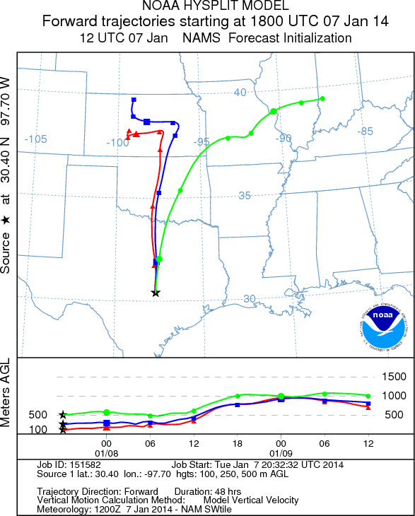
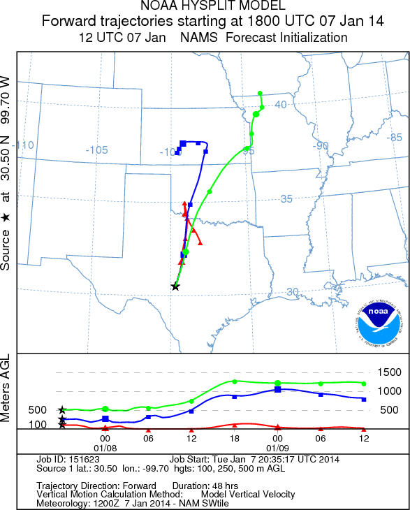
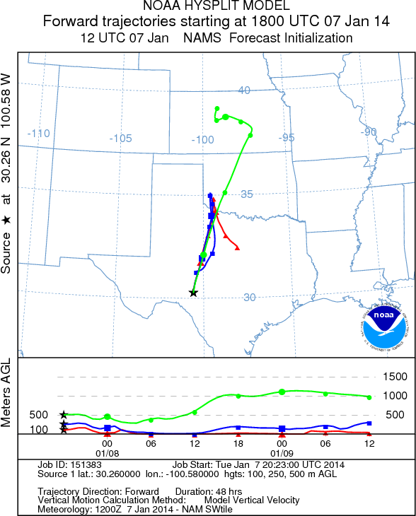
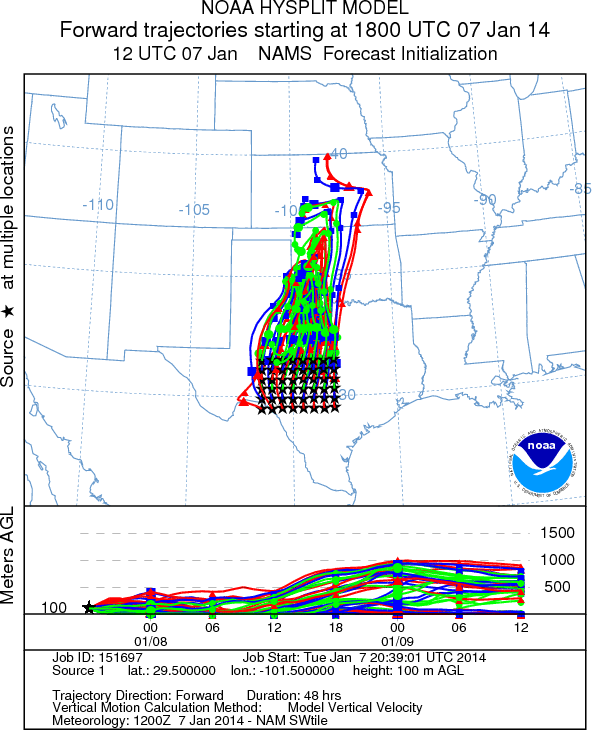
Trajectory Start (s) (shown by *
on map): Austin, TX; Junction, TX; Sonora, TX.
AUSTIN
JUNCTION
SONORA
EDWARDS PLATEAU COMPOSITE
Prepared by: Estelle
Levetin (Faculty of Biological
Science, The
University of Tulsa, 800 S. Tucker Dr., Tulsa, OK 74104) and ) and Peter
K Van de Water (Department of Earth and Environmental Science, California State University Fresno,
2576 East San Ramon Avenue, M/S ST24, Fresno CA 93740-8039). This forecast gives the anticipated future track of
released Mountain Cedar pollen, weather conditions over the region and along the forecast pathway, and an estimated
time of arrival for various metropolitan areas.
Questions: Aerobiology Lab e-mail: pollen@utulsa.edu
Return to Forecasting Home Page