The University of Tulsa
Mountain Cedar Pollen Forecast

Metropolitan Area |
Exposure Risk |
|
Oklahoma City |
Low |
|
Tulsa |
Low |
|
St. Louis MO |
Low |
Date Issued: 8 January 2014
Mountain Cedar Location(s): Arbuckle Mountains, OK
Regional Weather: Wednesday, January 8 TX/OK: Across
the region, Oklahoma through Texas, southerly winds that build in after the very cold conditions earlier in the
week will bring moisture to the area. In Oklahoma there will be a chance of drizzle this afternoon with high temperatures
in the upper 30s to low 40s. Winds will be from the south at 10 to 15 mph. Tonight there is the possibility of
freezing drizzle or light snow in Oklahoma. To the south in Texas, moisture with fog and drizzle will occur in
the Dallas/Ft. Worth area southward along the communities surrounding the Edwards Plateau. There will be fog in
the morning and a 20% to 40% chance of drizzle and rain throughout the day extending to San Antonio. Temperatures
will be in the mid to upper 50s across Texas with the westernmost areas getting close to 60 degrees. Skies across
the region will be cloudy, except in the far western communities of the Edwards Plateau where skies will partly
to mostly cloudy conditions. Tonight the chance of rain will continue in the same communities spreading northward
into Oklahoma. Again, the western portions of the Edwards Plateau will be partly cloudy with temperatures dropping
into the mid to low 30s. The eastern Plateau along with the edge communities northward to north Texas temperatures
will be in the low 50s to the 40s. Winds across Texas will be mostly from the south, with the western Plateau
catching some northwest breezes. Across the area winds will be light to moderate. Tomorrow cloudy and mostly
cloudy conditions will remain. Temperatures will warm across Texas with most areas reaching the 60s. The chance
of rain in the communities surrounding the Edwards Plateau will remain but lessen a bit. Winds will be more from
the east and southeast in central and southern Texas. North Texas will see winds from the northeast at light levels
and in Oklahoma winds will be light and variable. Tomorrow night cloudy conditions will remain and across the
region there will be an increase in rain activity. Temperatures will be in the 50s and winds will be from the
southeast at light to moderate conditions. To the north in Oklahoma, rain is expected with temperatures in the
upper 30s to the north and low 40s along the border with Texas.
Trajectory weather: Air mass trajectories over the Arbuckle Mountains move northward on southerly flow this
afternoon. Today winds will be from the south at moderate speeds decreasing to light and variable conditions tonight.
Tomorrow winds will remain light and variable then pick up a bit from the southeast tomorrow night. This morning
there will be a chance of drizzle across the area. That chance of drizzle will build tonight with a 40% chance
of drizzle and rain in the Arbuckle Mountains. Temperatures will be close to freezing, thus towards the morning
there may be fog and freezing fog. High Temperatures tomorrow will be in the upper 40s and winds will remain light
and variable. Tomorrow night the chance of rain increases to 30% with winds out of the southeast at 10 mph. Low
temperatures will only fall into the lower 40s.
OUTLOOK: *** Low Threat Today and Low Threat Tomorrow *** Poor to fair conditions
for pollen release today from the Arbuckle Mountains as temperatures will be in the low to mid-40s and winds will
be from 10 to 15 mph from the south. The increasing moisture overnight and tomorrow will dampen the amount of
pollen released as well as the conditions leading to entrainment and travel. With all of this being said, Good
conditions exist to the south in Texas and its trajectories have the potential to bring concentrations across Oklahoma,
towards Tulsa and into Missouri (See Texas Forecast)
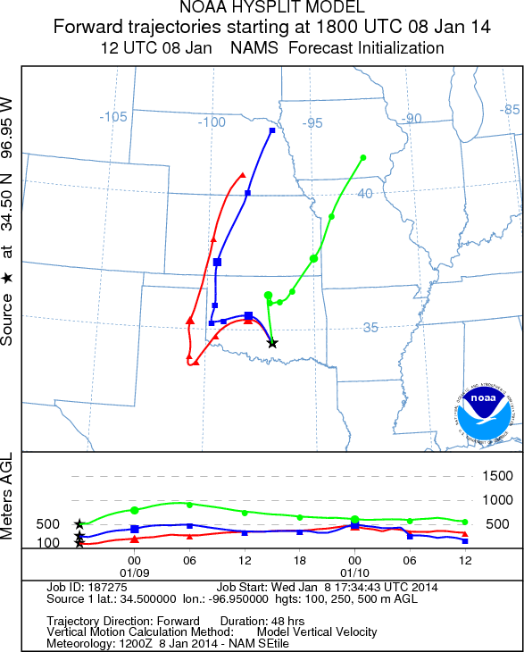
Trajectory Start (s) (shown by black
star on map): Davis, OK.
Prepared by: Estelle
Levetin
(Faculty
of Biological Science, The University of Tulsa, 800 S. Tucker Dr., Tulsa, OK 74104) and Peter
K Van de Water
(Department of Earth and Environmental Science, California State University Fresno, 2576 East San Ramon Avenue,
M/S ST24, Fresno CA 93740-8039). This forecast gives the anticipated future track of released Mountain Cedar pollen,
weather conditions over the region and along the forecast pathway, and an estimated time of arrival for various
metropolitan areas.
Questions: Aerobiology Lab e-mail: pollen@utulsa.edu
Return to Forecasting Home Page