
The University of Tulsa
Mountain Cedar Pollen Forecast
Metropolitan Area |
Exposure Risk |
|
Dallas/Fort Worth |
Moderate |
|
Austin |
Moderate |
|
San Antonio |
Moderate |
Date Issued: 8 January 2014
Mountain Cedar Location(s): Edwards Plateau, Texas
Regional Weather: Wednesday, January 8 TX/OK:
Across the region, Oklahoma through Texas, southerly winds that build in after the very cold conditions earlier
in the week will bring moisture to the area. In Oklahoma there will be a chance of drizzle this afternoon with
high temperatures in the upper 30s to low 40s. Winds will be from the south at 10 to 15 mph. Tonight there is
the possibility of freezing drizzle or light snow in Oklahoma. To the south in Texas, moisture with fog and drizzle
will occur in the Dallas/Ft. Worth area southward along the communities surrounding the Edwards Plateau. There
will be fog in the morning and a 20% to 40% chance of drizzle and rain throughout the day extending to San Antonio.
Temperatures will be in the mid to upper 50s across Texas with the westernmost areas getting close to 60 degrees.
Skies across the region will be cloudy, except in the far western communities of the Edwards Plateau where skies
will partly to mostly cloudy conditions. Tonight the chance of rain will continue in the same communities spreading
northward into Oklahoma. Again, the western portions of the Edwards Plateau will be partly cloudy with temperatures
dropping into the mid to low 30s. The eastern Plateau along with the edge communities northward to north Texas
temperatures will be in the low 50s to the 40s. Winds across Texas will be mostly from the south, with the western
Plateau catching some northwest breezes. Across the area winds will be light to moderate. Tomorrow cloudy and
mostly cloudy conditions will remain. Temperatures will warm across Texas with most areas reaching the 60s. The
chance of rain in the communities surrounding the Edwards Plateau will remain but lessen a bit. Winds will be
more from the east and southeast in central and southern Texas. North Texas will see winds from the northeast
at light levels and in Oklahoma winds will be light and variable. Tomorrow night cloudy conditions will remain
and across the region there will be an increase in rain activity. Temperatures will be in the 50s and winds will
be from the southeast at light to moderate conditions. To the north in Oklahoma, rain is expected with temperatures
in the upper 30s to the north and low 40s along the border with Texas.
Trajectory weather: Air mass trajectories over Texas move northward on a steady southerly flow over the
two days. Tomorrow winds will pick up a southeasterly component and slacken becoming lighter. Very cold air over
the Edwards Plateau has dissipated and warmer temperatures are expected with readings in the 40s and 50s today
rising to the 60s tomorrow. The edge communities with the southerly breezes heighten the chance of precipitation
today, tonight, tomorrow and then rain is expected tomorrow night. On the Plateau temperatures will be in the
50s to low 60s today and 60s tomorrow. The sites across Texas have been recording pollen over the past week or
so. It is expected that pollen will be in the atmosphere today as well. The winds appear to be buoyant with the
warming that will occur therefore it is expected that pollen will be entrained and will travel northward on the
southerly winds. Areas directly north of the Edwards Plateau including the Dallas/Ft. Worth region can expect
to be exposed to pollen. The pollen should extend into central Oklahoma then moving northeast towards Tulsa and
St. Louis. Levels could be moderate to high, although the winds are not particularly strong and thus travel will
moderate the amount that stays entrained. Tomorrow conditions will be similar during the morning, however the
winds will shift, coming from the southeast thus producing a slightly different path. In the afternoon, the chance
of precipitation will begin to build across Texas which may dampen not only release but wash entrained pollen out
of the atmosphere
OUTLOOK: *** Moderate Threat Today and High (AM)-Moderate
(PM) Threat Tomorrow *** Moderate to good conditions for pollen release today in the Texas populations
as warming conditions will occur across the area. Winds will be light to moderate but the atmosphere appears to
be very buoyant. Those conditions are good for entrainment and transport. Winds will be light to moderate, therefore
the overall distance traveled will be northward through central Oklahoma then easterly towards Tulsa and eventually
western Missouri. Tomorrow increasing amounts of moisture in the atmosphere will dampen the amount of pollen
released as well as the conditions leading to entrainment and travel.
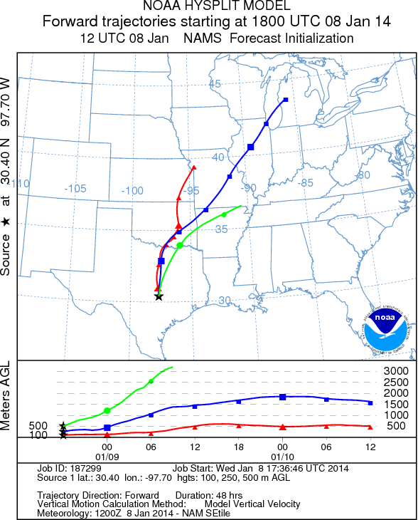
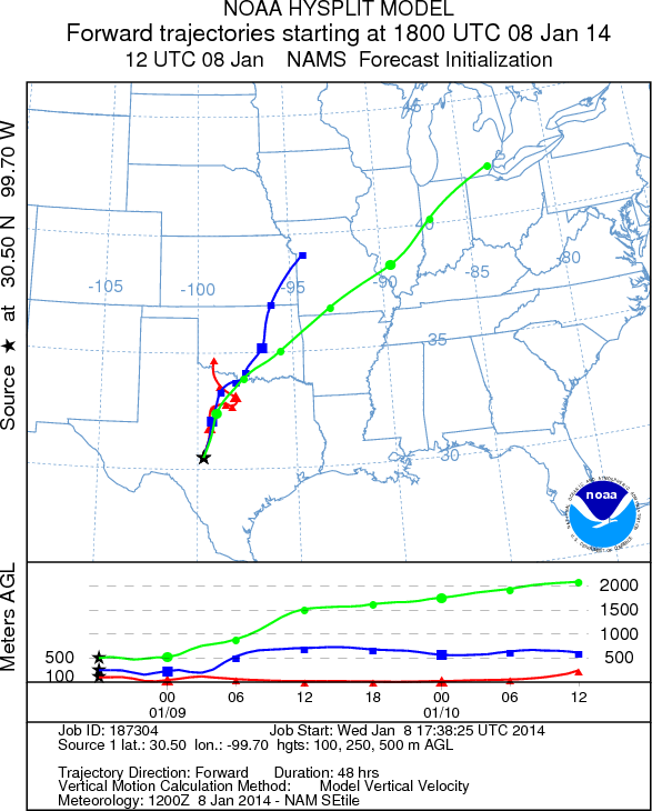
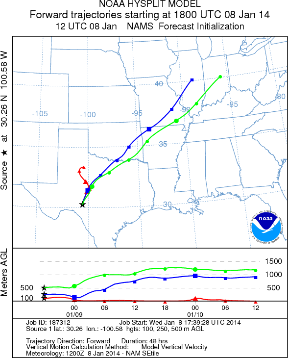
Trajectory Start (s) (shown by *
on map): Austin, TX; Junction, TX; Sonora, TX.
AUSTIN
JUNCTION
SONORA
EDWARDS PLATEAU COMPOSITE
Prepared by: Estelle
Levetin (Faculty of Biological
Science, The
University of Tulsa, 800 S. Tucker Dr., Tulsa, OK 74104) and ) and Peter
K Van de Water (Department of Earth and Environmental Science, California State University Fresno,
2576 East San Ramon Avenue, M/S ST24, Fresno CA 93740-8039). This forecast gives the anticipated future track of
released Mountain Cedar pollen, weather conditions over the region and along the forecast pathway, and an estimated
time of arrival for various metropolitan areas.
Questions: Aerobiology Lab e-mail: pollen@utulsa.edu
Return to Forecasting Home Page