
The University of Tulsa
Mountain Cedar Pollen Forecast
Metropolitan Area |
Exposure Risk |
|
Dallas/Fort Worth |
Low |
|
Austin |
Variable - see outlook below |
|
San Antonio |
Variable - see outlook below |
Date Issued: 10 January 2014
Mountain Cedar Location(s): Edwards Plateau, Texas
Regional Weather: Friday, January 10 TX/OK:
The region today, Oklahoma through Texas, will be wet with showers along the edge of the Edwards Plateau northward
into the Dallas/Ft. Worth region and on into Oklahoma. The chance of precipitation is greater to the north, in
Oklahoma and north Texas, but showers are expected across the Edwards Plateau and areas further south. Today temperatures
in Oklahoma will rise into the mid-50s to low-60s. Winds will be from the south at moderately strong conditions.
Rain and rain showers are expected to occur across the region this morning and then start to taper off in the
afternoon. Further to the south, the chance of precipitation from showers and thunderstorms is in the 40% to 50%
chance. This morning there are well developed rain showers along the edge of the Edwards Plateau and across the
eastern section out towards Fredricksburg TX. These showers are moving to the north-northeast. Temperatures in
Texas today will be in the mid- to low-70s. Winds across the region will be from the southwest funneling moisture
northward for the rain storms. On the ground winds will be moderate. Tonight the clouds will begin to break-up
and clear with clear to mostly clear skies expected. The Dallas/Ft. Worth metro region will hold onto a 20% chance
of shower and thunderstorms early but its skies will clear eventually. Low temperatures will be in the lower 30s
across Oklahoma and north Texas, and to the south on the Edwards Plateau. The communities surrounding the Plateau
will remain in the 40s overnight. Tomorrow, sunny skies will occur across the region. Temperatures to the north
will build into the 60s as will areas on the western side of the Edwards Plateau. To the east on the Plateau
temperatures will reach into the 70s. Winds in the communities surrounding the Edwards Plateau will be from the
north at light levels. The rest of the region shows a dominant light westerly wind. Tomorrow night clear skies
will bring low temps in Oklahoma into the mid- 30s and the remainder of the area will be in the 40s. A southerly
wind will move into the region at moving air northward from the south.
Trajectory weather: Air mass trajectories over Texas move slowly to the east-northeast over eastern Texas.
The trajectories will be mixed with the moisture that is moving across Texas this morning on light to moderate
southwesterly winds. Showers are currently occurring across most of the eastern Plateau region and especially
northward into Dallas/Ft. Worth metro area and northwards into Oklahoma. As the moisture continues to move off
to the east, skies will begin to clear. Today temperatures will be very warm with most areas headed towards the
low to mid 70s. Tonight rain will taper off in the Dallas/Ft. Worth metro area. Other areas will start to clear
this afternoon and tonights skies will be clear region wide. Winds will be from the west and northwest driving
the trajectories over eastern Texas. Tomorrow skies will remain sunny and temperatures will return to the 70s
in the communities surrounding the Edwards Plateau. Temperatures in the upper 60s are expected on the Plateau
itself. Tomorrow night clear skies will remain with mild overnight temperatures. Most areas will be in the mid
40s. Winds will be shifting tomorrow night coming from the south by morning.
OUTLOOK: *** MIXED Threat Today and Moderate to High Threat Tomorrow *** Conditions for pollen release today will depend upon the duration
of the rain showers in any given area. In areas which receive a soaking rain pollen should be washed from the
skies. In areas where little rain hits the ground but there are blustery conditions with nearby thunderstorms
pollen may be shed and entrained within the atmosphere. Areas on the Edwards Plateau that do not receive rainfall
are showing significant releases of pollen today. High concentrations are expected in these areas. The radar
indicates that there are significant rains to the north and these areas should provide a boundary with most of
the pollen washed out of the atmosphere in those areas. Therefore the real threat for pollen exposure will be
on the Edwards Plateau and in some of the surrounding communities. Once the rain moves through the area, the
Texas populations will be under warm conditions and all indications are that plenty of pollen is ready to be released.
Look for increasing levels on Saturday.
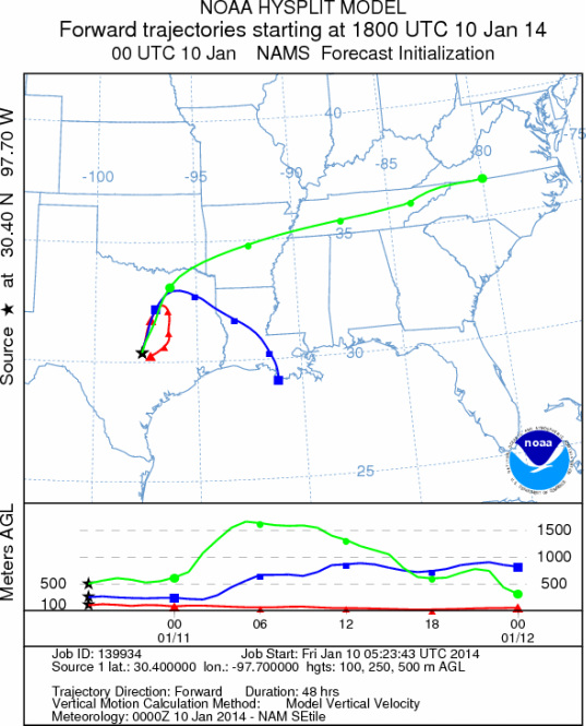
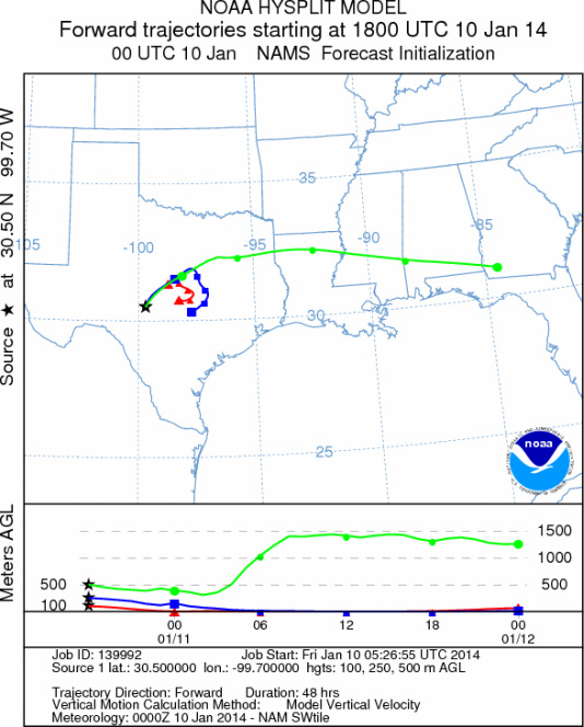
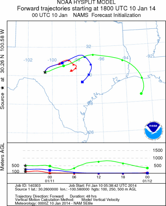
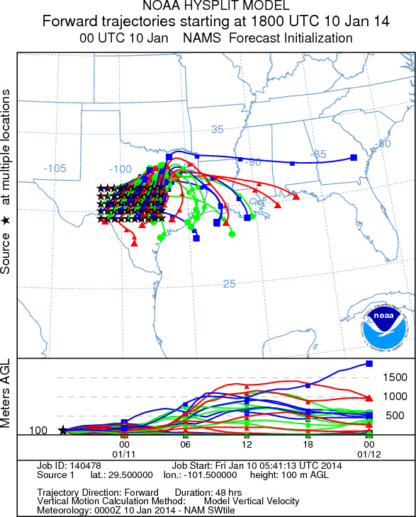
Trajectory Start (s) (shown by *
on map): Austin, TX; Junction, TX; Sonora, TX.
AUSTIN
JUNCTION
SONORA
EDWARDS PLATEAU COMPOSITE
Prepared by: Estelle
Levetin (Faculty of Biological
Science, The
University of Tulsa, 800 S. Tucker Dr., Tulsa, OK 74104) and ) and Peter
K Van de Water (Department of Earth and Environmental Science, California State University Fresno,
2576 East San Ramon Avenue, M/S ST24, Fresno CA 93740-8039). This forecast gives the anticipated future track of
released Mountain Cedar pollen, weather conditions over the region and along the forecast pathway, and an estimated
time of arrival for various metropolitan areas.
Questions: Aerobiology Lab e-mail: pollen@utulsa.edu
Return to Forecasting Home Page