The University of Tulsa
Mountain Cedar Pollen Forecast

Metropolitan Area |
Exposure Risk |
|
Oklahoma City |
Severe |
|
Tulsa |
High |
|
St. Louis MO |
Moderate |
Date Issued: 11 January 2014
Mountain Cedar Location(s): Arbuckle Mountains, OK
Regional Weather: Saturday/Sunday, January 11/12 TX/OK:
The region today, Oklahoma through Texas, will be under sunny skies with seasonably warm conditions and light winds
resulting in very good conditions for pollen release today and tomorrow. Those who are affected should keep their
boxes of tissues handy. This is the first extended period of this pollen season where the region is under conditions
that are very conducive to pollen release and local to long distance dispersal. Across Oklahoma and Texas skies
will be sunny today and tomorrow. Temperatures today will be in the mid-60s in Oklahoma, northern Texas, and on
the Edwards Plateau. In the communities surrounding the Plateau temperatures will climb into the 70s. Today
winds will be light from the west in the northern portion of the region, from the north along the edge of the Edwards
Plateau, and from the southwest to west on the Plateau itself. Tonight clear to mostly clear skies will remain
with temperatures dropping into the mid-30s to the west and north. The eastern Edwards Plateau along with the
surrounding communities will drop into the low to mid 40s. Winds will be light and variable throughout the region.
Tomorrow will begin with similar conditions, however afternoon winds will begin to pick-up from the south first
at light to moderate conditions and later in the day at strong, 20 to 30 mph, levels. The southerly winds will
bring more moisture from the south, thus the skies will become partly cloudy tomorrow night. Temperatures will
drop into the 30s on the Plateau and to the north. The eastern Plateau and surrounding communities will be in
the 40s. Winds will start from the south, but eventually switch coming from the west as we approach Monday morning.
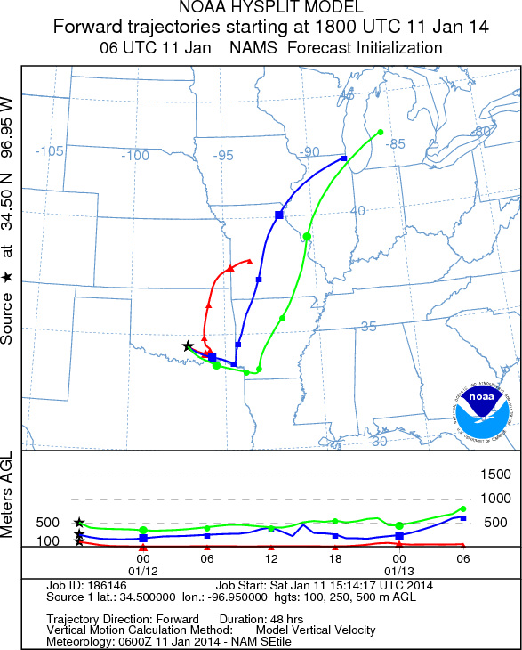
Trajectory weather: Air mass trajectories over the Arbuckle Mountains move slowly to the east-southeast
on light winds over the southern Oklahoma region. The trajectories will move this direction during the day and
then once southerly winds kick in overnight it turn abruptly northward. This results in the pollen from southern
Oklahoma will travel a distance that will be constrained. With the light winds the ability of the air to entrain
pollen and move it will be dampened to some extent. However, there is good evidence that the trees are ready to
release significant amounts of pollen south in Texas and similar conditions are expected in southern Oklahoma.
This will be aided by the warm temperatures, mid-60s, today and especially tomorrow when the highs are expected
to be in the low 70s. Tomorrow winds will pick-up, becoming moderate to strong conditions from the south. This
will increase the ability of the air to entrain and transport pollen long distances. With the dominant southerly
flow areas in northern Oklahoma and onward are in danger of having significant concentrations of pollen in their
atmosphere
OUTLOOK: *** Severe Threat today and Severe Threat Tomorrow *** Conditions for
pollen release today are very good with warm temperatures but with light and variable winds. Trees were releasing
pollen yesterday on the Edwards Plateau and todays conditions will be better for release across the region. Entrainment
and travel will be somewhat subdued today with light winds, but tomorrow conditions will actually improve with
even warmer temperatures across the region and a strong flow of air from the south for entrainment and travel.
The Arbuckle Mountains populations will be under warm conditions the entire weekend and all indications are that
plenty of pollen is ready to be released. In addition, look for increasing levels of pollen and increasing entrainment
and travel from Texas on Sunday.
Trajectory Start (s) (shown by black
star on map): Davis, OK.
Prepared by: Estelle
Levetin
(Faculty
of Biological Science, The University of Tulsa, 800 S. Tucker Dr., Tulsa, OK 74104) and Peter
K Van de Water
(Department of Earth and Environmental Science, California State University Fresno, 2576 East San Ramon Avenue,
M/S ST24, Fresno CA 93740-8039). This forecast gives the anticipated future track of released Mountain Cedar pollen,
weather conditions over the region and along the forecast pathway, and an estimated time of arrival for various
metropolitan areas.
Questions: Aerobiology Lab e-mail: pollen@utulsa.edu
Return to Forecasting Home Page