
The University of Tulsa
Mountain Cedar Pollen Forecast
Metropolitan Area |
Exposure Risk |
|
Dallas/Fort Worth |
Moderate |
|
Austin |
High |
|
San Antonio |
High |
Date Issued: 15 January 2014
Mountain Cedar Location(s): Edwards Plateau, Texas
Regional Weather: Wednesday, January 15 TX/OK:
The region today, Oklahoma through Texas, will once again be under mostly sunny skies with seasonably warm conditions
with the high temperatures in the 60s across the Edwards Plateau and in the surrounding communities. Dallas/Ft.
Worth and northward will be in the mid to upper 50s although cooler temperatures will occur in Oklahoma. Over
the forecast period winds will be swirling over the region. Today the northern areas will see light winds from
the west. Across the Edwards Plateau a western air flow will also occur at light wind levels except to the far
west where the flow will be a bit stronger. In the communities surrounding the Plateau the flow will be from the
northwest. Tonight clear skies will occur with the region dropping into the 30s, but staying above freezing.
Winds will remain light but be out of the southwest. Tomorrow will begin with mostly sunny to sunny skies. Temperatures
will warm a bit from today with the entire region reaching the 60s. The communities surrounding the Edwards Plateau
will remain with a southwesterly flow at light to moderate levels. To the north winds will be moderate from the
northwest and across the Edwards Plateau most areas will be from the west, but the far western communities will
see a shift in the winds coming from the north that will overtake the region tomorrow night. Tomorrow night northerly
winds will bring colder conditions with Oklahoma and the Edwards Plateau falling into the 20s and the surrounding
communities in the mid to low 30s.
Trajectory weather: Air mass trajectories over Texas swirl over the region today with mixed conditions.
Today winds will be from the west from the Dallas/ Ft. Worth region into Oklahoma and on the Edwards Plateau.
In the surrounding communities winds will be from the northwest moving trajectories to the southeast. Wind conditions
today will be light. Tonight winds will move to a more southwesterly flow at light levels. Then tomorrow the
northern areas will return to a northwest flow, whereas the Edwards Plateau will see light to moderate winds from
the west on the Plateau and from the southwest in the surrounding communities. To the west winds will shift coming
from the north and will signal a regional shift to a northerly flow overnight tomorrow. With all of this air movement
the atmosphere will continue to be dense, with movement at and/or near ground level. Conditions overall will be
good today for pollen release with temperatures climbing to the 60s with light to moderate winds. However the
dense air will have the entrained pollen moving close to the ground where impaction on other surfaces is thought
to be a major factor in removing pollen from the atmosphere. Pollen that does travel some distance will impact
allergy sufferers mostly in and around those areas that host the actual trees. In other words the next two days
will see pollen concentrations mostly in the areas where the pollen is being released.
OUTLOOK: *** Severe Threat Today and Severe Threat Tomorrow *** Conditions for
pollen release today remain very good with warm temperatures and light to moderate winds. However the air is dense
and so entrainment and travel will be a bit subdued. Trees were releasing pollen yesterday on the Edwards Plateau
and todays conditions will be about the same in terms of the temperatures. The Texas populations will be under
warm conditions the entire forecast period and all indications are that plenty of pollen remains ready to be released
and entrained into the atmosphere. High levels continue to be recorded at reporting stations across the region.
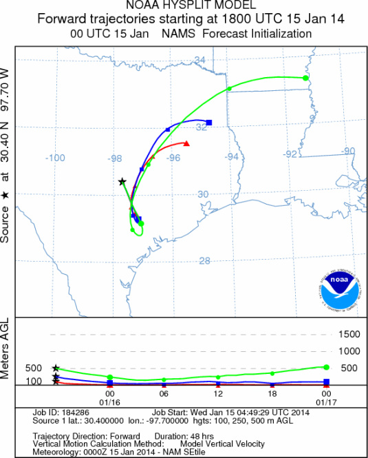
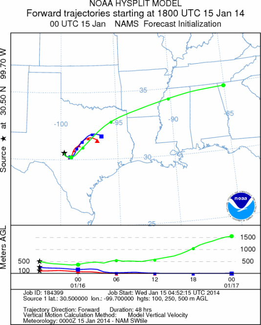
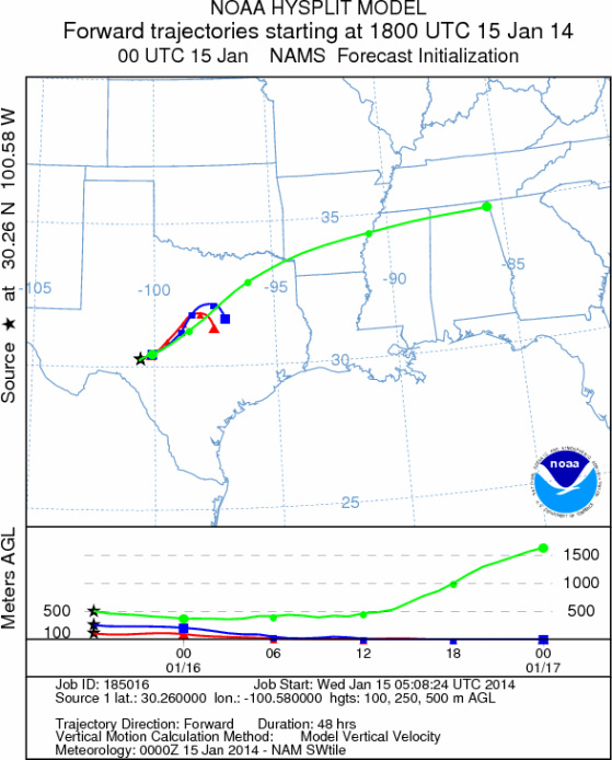
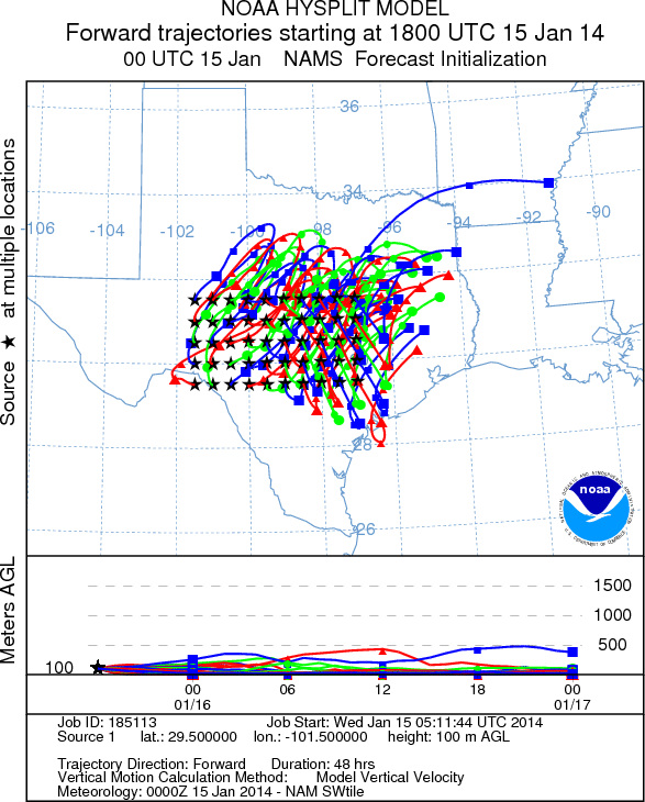
Trajectory Start (s) (shown by *
on map): Austin, TX; Junction, TX; Sonora, TX.
AUSTIN
JUNCTION
SONORA
EDWARDS PLATEAU COMPOSITE
Prepared by: Estelle
Levetin (Faculty of Biological
Science, The
University of Tulsa, 800 S. Tucker Dr., Tulsa, OK 74104) and ) and Peter
K Van de Water (Department of Earth and Environmental Science, California State University Fresno,
2576 East San Ramon Avenue, M/S ST24, Fresno CA 93740-8039). This forecast gives the anticipated future track of
released Mountain Cedar pollen, weather conditions over the region and along the forecast pathway, and an estimated
time of arrival for various metropolitan areas.
Questions: Aerobiology Lab e-mail: pollen@utulsa.edu
Return to Forecasting Home Page