
The University of Tulsa
Mountain Cedar Pollen Forecast
Metropolitan Area |
Exposure Risk |
|
Dallas/Fort Worth |
Moderate |
|
Austin |
High |
|
San Antonio |
High |
Date Issued: 17 January 2014
Mountain Cedar Location(s): Edwards Plateau, Texas
Regional Weather: Friday, January 17 TX/OK:
The region today, Oklahoma through Texas, continues under mostly sunny skies. Today high temperatures will be
cooler than the last couple of days with high temperatures in the 50s in southern Oklahoma and across the Edwards
Plateau. In the surrounding communities temperatures will return to the 60s. Tomorrow the entire region will
be in the 60s. Winds today will mostly be from the north and hence the cooling. Winds will be from the northwest
at light conditions across Oklahoma stretching into the north Texas region. On the Edwards Plateau the winds will
be from the north and northeast. The southwestern areas of the Plateau will be light from the southeast. Overnight
winds will be very light and an increasing southerly flow will take over. Temperatures tonight will be in the
30s region wide. However, most areas will remain above freezing. Tomorrow sunny and partly sunny skies remain
with temperatures in the mid to upper 60s across the region. Winds will become light to moderate with an overall
coming from the southwest. Across Oklahoma the flow will be more of a westerly flow. Tomorrow night mostly clear
skies remain. Temperatures will fall into the 30s but most areas will stay above freezing. Across Texas the southwest
to westerly flow will remain. In Oklahoma colder air will be pushing southwards again from the northwest.
Trajectory weather: Air mass trajectories over Texas will begin the day somewhat mixed with light winds
from the north and northwest. These light wind conditions will continue overnight. The atmosphere will be cooler
today and relatively dense with minor amounts of movement thus entrainment and travel of entrained pollen should
be reduced. Tomorrow, however a moderate southwesterly flow takes over and temperatures will rise back into the
60s across the region. Winds will be light to moderate and with the warming the atmosphere should be more buoyant.
Tomorrow night the southwesterly winds will shift coming more from the west. Eventually late tomorrow night into
Sunday morning another push of air from the northwest begins to move south over the region. Temperatures today
will just get into the 60s in the surrounding communities and be in the mid to upper 50s across the rest of the
area. The atmosphere over the region will be dense with the cooler temperatures, and then very light winds tonight.
Warming tomorrow should get pollen entrained and the southwesterly flow will move it towards the east.
OUTLOOK: *** High Threat today and Severe Threat Tomorrow *** Conditions for pollen release today remain
good but less so than the past week. Temperatures will be cooling with most areas only in the 50s. Winds will
be light especially tonight and the air should be dense. The trajectories will be moving along short pathways
with the light winds today and tonight, therefore the greatest threat will occur to those areas within the populations
and the adjoining regions. Tomorrow conditions improve and a light to moderate air flow over the region from the
southwest will bring more buoyant air for travel and entrainment to the east. Trees were releasing pollen yesterday
on the Edwards Plateau and todays conditions are expected to be subdued because of the lower temperatures. The
threat tomorrow will ramp up with warmer conditions and stronger winds. All indications are that plenty of pollen
remains ready to be released and entrained into the atmosphere. High levels continue to be recorded at reporting
stations across the region.
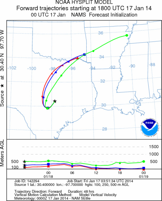
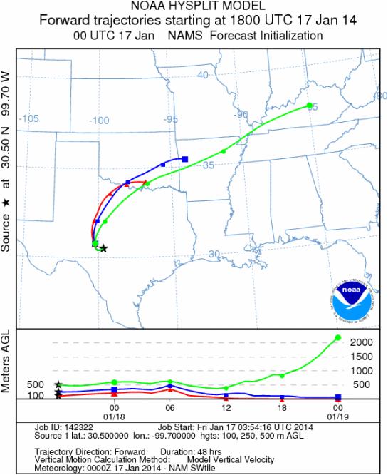
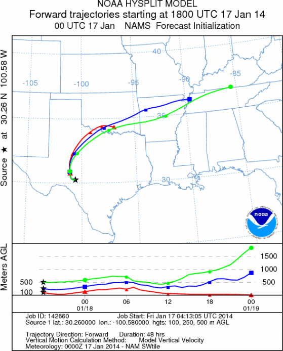
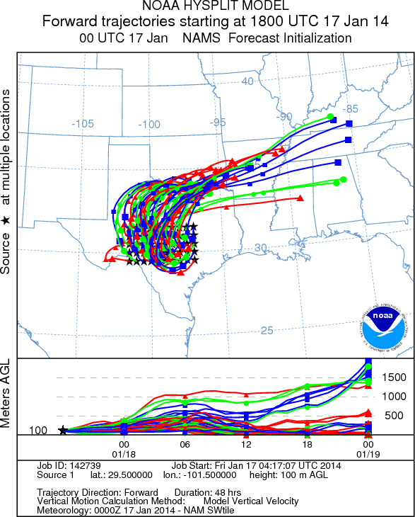
Trajectory Start (s) (shown by *
on map): Austin, TX; Junction, TX; Sonora, TX.
AUSTIN
JUNCTION
SONORA
EDWARDS PLATEAU COMPOSITE
Prepared by: Estelle
Levetin (Faculty of Biological
Science, The
University of Tulsa, 800 S. Tucker Dr., Tulsa, OK 74104) and ) and Peter
K Van de Water (Department of Earth and Environmental Science, California State University Fresno,
2576 East San Ramon Avenue, M/S ST24, Fresno CA 93740-8039). This forecast gives the anticipated future track of
released Mountain Cedar pollen, weather conditions over the region and along the forecast pathway, and an estimated
time of arrival for various metropolitan areas.
Questions: Aerobiology Lab e-mail: pollen@utulsa.edu
Return to Forecasting Home Page