The University of Tulsa
Mountain Cedar Pollen Forecast

Metropolitan Area |
Exposure Risk |
|
Oklahoma City |
Low Saturday/Moderate Sunday |
|
Tulsa |
Low Saturday/High Sunday |
|
St. Louis MO |
Low |
Date Issued: 18/19 January 2014
Mountain Cedar Location(s): Arbuckle Mountains, OK
Regional Weather: Saturday/ Sunday, January 18/19 TX/OK:
The region remains under sunny skies today and tomorrow. Temperatures today will climb into the upper 60s across
Texas with San Antonio getting close to the 70 degree mark. In Oklahoma the highs will reach to the mid- 60s.
Winds will be moderate from the west to the north in Oklahoma. Across Texas a southwesterly flow will settle
in. The southwestern areas of the Edwards Plateau will see more of a west to east flow. Winds will be light to
moderate except for the Dallas/Ft. Worth metro area where moderate to strong winds will build during the afternoon.
Tonight clear and mostly clear skies will remain. Temperatures across Texas will drop to the low 40s in the communities
surrounding the Edwards Plateau. On the Plateau temperatures will cool to the low 30s with light frost in many
areas. In Oklahoma, readings in the low 30s area expected. Winds to the north will initially be from the northwest
and then become light and variable overnight. Across Texas the air will flow from west to east at light levels.
Sunday will dawn with sunny skies across the region once again. Temperatures will be a repeat of Saturday with
most areas in the mid to upper 60s and rising into the low 70s in the San Antonio region. The winds that were
primarily from the west on Saturday will become a more southwesterly flow over the region and this will dominate
over Sunday night. Winds will remain light during the day. Tomorrow night mostly clear skies will dominate with
temperatures falling into the upper 30s on the Edwards Plateau and Oklahoma, with the surrounding communities in
the low 40s. Winds across the region will be more dominant from the south and the southwest.
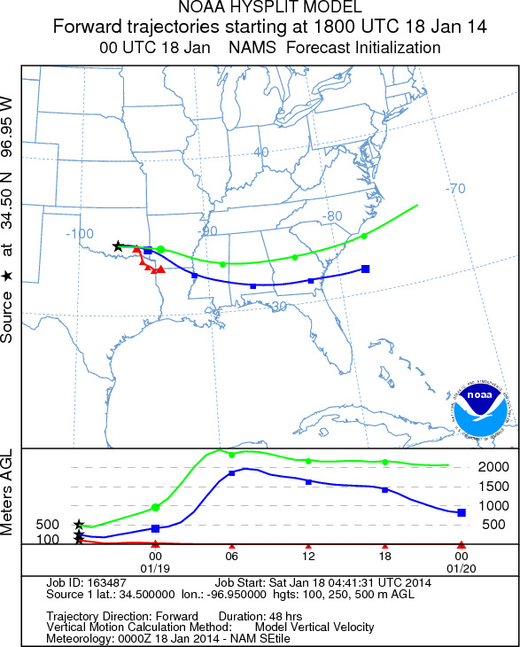
Trajectory weather: Air mass trajectories over Southern Oklahoma will begin the day being pushed by moderate
winds from the west. Overnight lows will keep cold air at the ground leve, but high temperatures are expected
to reach into the mid-60s. As warming occurs today the air will become more buoyant and it is expected that pollen
will become entrained and travel across the region. At ground level the distance will be minimal, but at upper
levels stronger winds will take any entrained pollen eastward towards northern Louisiana. Tonight winds will become
dominantly from the northwest and temperatures will drop back to the low 30s. Tomorrow sunny skies will occur.
Winds will be from the southwest and the region is expected to warm back into the upper 60s. Similar conditions
are expected with ground level air being dense but warming producing buoyancy and entrained pollen moving to the
northeast on southwesterly winds. Conditions are expected to be good for entrainment and travel over the region
once again. Overnight tomorrow winds will remain light to moderate from the south to southwest.
OUTLOOK: *** Severe Threat Today and Severe Threat Tomorrow *** Conditions for
pollen release today remain excellent. Temperatures will be warming into the mid-60s today and upper 60s tomorrow.
Winds will be light to moderate today and the air will become more buoyant with the warming as the day warms.
The trajectories will be moving along short pathways at ground level but entrainment will push the pollen long
distances. Upper level trajectories will push pollen eastward today towards Louisiana, southern Arkanasa into the
southern US states. tomorrow trajectories more to the east northeast. All indications are that plenty of pollen
remains ready to be released and entrained into the atmosphere. High levels continue to be recorded at reporting
stations across the region and with continued warm day time temperatures no let up is seen in the near future.
Trajectory Start (s) (shown by black
star on map): Davis, OK.
Saturday, January 18
Sunday, January 19
Prepared by: Estelle
Levetin
(Faculty
of Biological Science, The University of Tulsa, 800 S. Tucker Dr., Tulsa, OK 74104) and Peter
K Van de Water
(Department of Earth and Environmental Science, California State University Fresno, 2576 East San Ramon Avenue,
M/S ST24, Fresno CA 93740-8039). This forecast gives the anticipated future track of released Mountain Cedar pollen,
weather conditions over the region and along the forecast pathway, and an estimated time of arrival for various
metropolitan areas.
Questions: Aerobiology Lab e-mail: pollen@utulsa.edu
Return to Forecasting Home Page