
The University of Tulsa
Mountain Cedar Pollen Forecast
Metropolitan Area |
Exposure Risk |
|
Dallas/Fort Worth |
Moderate Saturday/High Sunday |
|
Austin |
Severe |
|
San Antonio |
Severe |
Date Issued: 18/19 January 2014
Mountain Cedar Location(s): Edwards Plateau, Texas
Regional Weather: Saturday/ Sunday, January 18/19 TX/OK:
The region remains under sunny skies today and tomorrow. Temperatures today will climb into the upper 60s across
Texas with San Antonio getting close to the 70 degree mark. In Oklahoma the highs will reach to the mid- 60s.
Winds will be moderate from the west to the north in Oklahoma. Across Texas a southwesterly flow will settle
in. The southwestern areas of the Edwards Plateau will see more of a west to east flow. Winds will be light to
moderate except for the Dallas/Ft. Worth metro area where moderate to strong winds will build during the afternoon.
Tonight clear and mostly clear skies will remain. Temperatures across Texas will drop to the low 40s in the communities
surrounding the Edwards Plateau. On the Plateau temperatures will cool to the low 30s with light frost in many
areas. In Oklahoma, readings in the low 30s area expected. Winds to the north will initially be from the northwest
and then become light and variable overnight. Across Texas the air will flow from west to east at light levels.
Sunday will dawn with sunny skies across the region once again. Temperatures will be a repeat of Saturday with
most areas in the mid to upper 60s and rising into the low 70s in the San Antonio region. The winds that were
primarily from the west on Saturday will become a more southwesterly flow over the region and this will dominate
over Sunday night. Winds will remain light during the day. Tomorrow night mostly clear skies will dominate with
temperatures falling into the upper 30s on the Edwards Plateau and Oklahoma, with the surrounding communities in
the low 40s. Winds across the region will be more dominant from the south and the southwest.
Trajectory weather: Air mass trajectories over Texas will begin the day somewhat mixed with light winds
from the southwest. The light wind conditions will continue overnight with the Texas region remaining with a westerly
flow. Temperatures today will warm back to levels of the past week with highs in the upper 60s in most areas and
70s in the southwestern Edwards Plateau edge communities. As warming occurs today the air will become more buoyant
and it is expected that pollen will become entrained and travel swirling across the region. On the eastern portion
of the Plateau and the surrounding communities, pollen entrained into the upper portion of the atmosphere will
move over eastern Texas and into Louisiana. Tonight winds will become dominantly from the west and southwest across
Texas. Tomorrow sunny skies will occur. Winds will vary from the north in the edge communities to a southerly
to southwesterly flow over the Edwards Plateau. Winds will be mostly light pushing most of the surface winds northward.
Conditions are expected to be good for entrainment and travel over the region once again. Overnight tomorrow winds
will remain light to moderate from the south to southwest.
OUTLOOK: *** Severe Threat Today and Severe Threat Tomorrow *** Conditions for
pollen release today remain excellent. Temperatures will be warming from yesterday with most areas back in the
60s. Winds will be light to moderate today and the air will become more buoyant with the warming during the day.
The trajectories will be moving along short pathways with the light winds today and tonight, therefore the greatest
threat will occur to those areas within the populations and the adjoining regions. Tomorrow conditions return
and a light to moderate air flow over the plateau from the southwest and from the north along the Plateau edge
will bring more buoyant air for travel and entrainment. Modelling suggest that most of the trajectories will travel
northward. All indications are that plenty of pollen remains ready to be released and entrained into the atmosphere.
High levels continue to be recorded at reporting stations across the region.
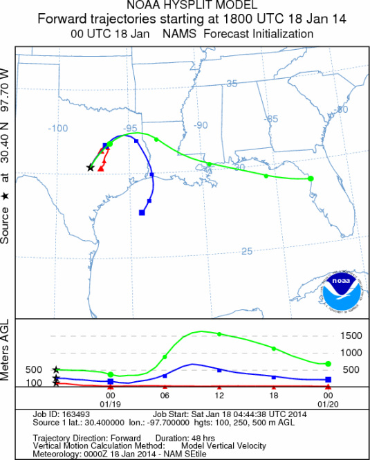
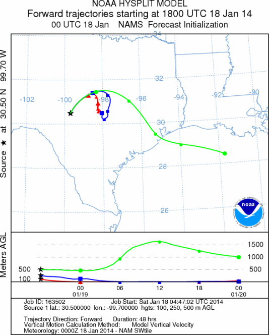
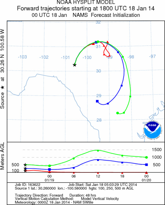
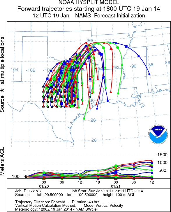
Trajectory Start (s) (shown by *
on map): Austin, TX; Junction, TX; Sonora, TX.
AUSTIN
JUNCTION
SONORA
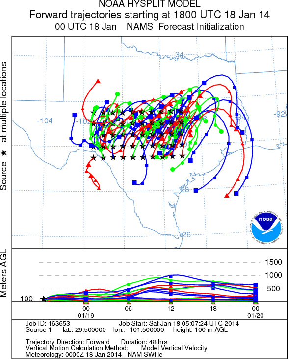
EDWARDS PLATEAU COMPOSITE
Satuday, January 18
Sunday, January 19
Prepared by: Estelle
Levetin (Faculty of Biological
Science, The
University of Tulsa, 800 S. Tucker Dr., Tulsa, OK 74104) and ) and Peter
K Van de Water (Department of Earth and Environmental Science, California State University Fresno,
2576 East San Ramon Avenue, M/S ST24, Fresno CA 93740-8039). This forecast gives the anticipated future track of
released Mountain Cedar pollen, weather conditions over the region and along the forecast pathway, and an estimated
time of arrival for various metropolitan areas.
Questions: Aerobiology Lab e-mail: pollen@utulsa.edu
Return to Forecasting Home Page