
The University of Tulsa
Mountain Cedar Pollen Forecast
Metropolitan Area |
Exposure Risk |
|
Dallas/Fort Worth |
High |
|
Austin |
Severe |
|
San Antonio |
Severe |
Date Issued: 20 January 2014
Mountain Cedar Location(s): Edwards Plateau, Texas
Regional Weather: -Monday, January 20 TX/OK:
The region remains under sunny skies today and tomorrow. Southern Oklahoma will be sunny today with high temperatures
reaching the mid-60s, clear tonight and sunny again tomorrow. This morning the areas surrounding the Edwards Plateau
will start partly cloudy with a chance of patchy fog in places. The partly cloudy skies will extend westward out
towards Fredericksburg to Junction. The cloudy conditions will burn off resulting in mostly sunny skies. High
temperatures across Texas will be in the 70s with the southern most areas climbing into the upper 70s. Winds
will begin the day at light levels from the southwest. During the day they will build towards moderate conditions.
The winds will shift towards the west in the afternoon and starting across the western areas of the Edwards Plateau,
winds will eventually come out of the northwest. Overnight winds will be from the north at moderate levels. Low
temperatures to the north in Oklahoma will be in the mid-20s. To the south, lows will remain in the mid-30s with
low 40s in the surrounding communities. The cold air moving south tonight will lower temperatures tomorrow. The
Edwards Plateau will go from 70s, to most areas only getting into the 50s on Tuesday. San Antonio, which should
reach the upper 70s today, will struggle to get to 60. Skies will be sunny with light to moderate winds moving
towards the south. The western most area of the Edwards Plateau will show a wind shift returning back to a southwest
flow. Tomorrow night mostly cloudy conditions will build in and temperatures will be in the low 20s to the north
in Oklahoma and across the Plateau. The surrounding communities will be in the low 30s. Winds will be very light
and mixed as an overall southwesterly flow takes over from the push of cold northerly air across the region
Trajectory weather: Air mass trajectories over Texas will begin the day with moderate winds from the southwest.
The winds will move at light to moderate conditions to the northeast early, but a push of cold air will begin
to come into the region turning those trajectories to the south on north and northwesterly winds. High temperatures
today will be warm with the entire Texas region getting into the 70s. The skies will be mostly sunny after some
partly cloudy conditions this morning. The southwesterly winds will be bringing humidity into the region. The
shift in winds towards a northwesterly flow will start on the western side of the Edwards Plateau thus the trajectories
will begin to move southward on the northwesterly flow prior to the winds on the eastern Plateau. However, by
tonight the trajectories will all be moving southward. With the turn to the south, the colder air will be mixing
with the warmer atmosphere to the south and thus the atmosphere will become buoyant and better for entrainment
and travel. Tomorrow the northerly winds will continue to move air masses southward. With the cold air temperatures
will be up to 20 degrees colder than today. Tomorrow night lows will fall close to and below freezing in most
of the area. Winds will begin to become mixed as the southerly flow begins to push back into the region starting
to the southwest on the Edwards Plateau.
OUTLOOK: *** Severe Threat Today and High Threat Tomorrow *** Conditions for pollen
release today remain excellent with temperatures in the 70s across the region. Temperatures tomorrow will cool
significantly as cold air from the north moves south overnight. Winds will be moderate today and the air will
become more buoyant with the warming. Initially the winds will move from the southwest to the northeast, but the
colder northerly flow will begin during the afternoon changing direction from the southwest towards the east.
Tomorrow conditions will cool significantly. Areas that today are in the 70s will struggle into the upper 50s.
Modelling suggest that most of the trajectories will start to travel northeasterly but then abruptly begin to
move southward on north to south air flow. All indications are that plenty of pollen remains ready to be released
and entrained into the atmosphere. High levels continue to be recorded at reporting stations across the region.
It will be interesting with the push of cold air if levels begin to decline.
Trajectory Start (s) (shown by *
on map): Austin, TX; Junction, TX; Sonora, TX.
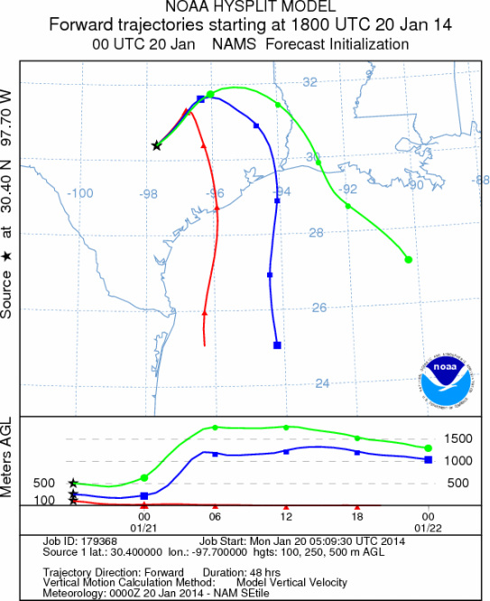
AUSTIN
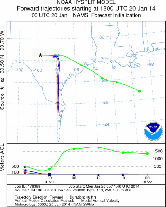
JUNCTION
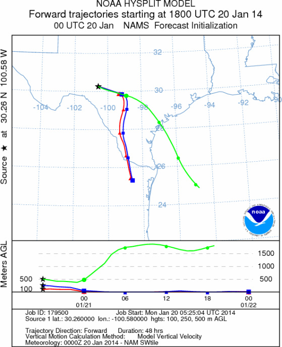
SONORA
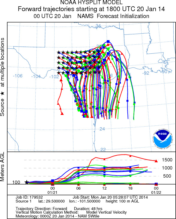
EDWARDS PLATEAU COMPOSITE
Prepared by: Estelle
Levetin (Faculty of Biological
Science, The
University of Tulsa, 800 S. Tucker Dr., Tulsa, OK 74104) and ) and Peter
K Van de Water (Department of Earth and Environmental Science, California State University Fresno,
2576 East San Ramon Avenue, M/S ST24, Fresno CA 93740-8039). This forecast gives the anticipated future track of
released Mountain Cedar pollen, weather conditions over the region and along the forecast pathway, and an estimated
time of arrival for various metropolitan areas.
Questions: Aerobiology Lab e-mail: pollen@utulsa.edu
Return to Forecasting Home Page