The University of Tulsa
Mountain Cedar Pollen Forecast

Metropolitan Area |
Exposure Risk |
|
Oklahoma City |
Low |
|
Tulsa |
Low |
|
St. Louis MO |
Low |
Date Issued: 22 January 2014
Mountain Cedar Location(s): Arbuckle Mountains, OK
Regional Weather: Wednesday, January 22 TX/OK:
After a long run of sunny and warm conditions, the region will see a major change beginning today and into tomorrow.
Cold air from the northeast and the possibility of rain and freezing precipitation will occur over the forecast
period. Southern Oklahoma will start sunny today with high temperatures reaching the mid-50s. It will be clear
mostly clear but very cold with northeast winds. Lows tonight will be in the teens in central Oklahoma and low
20s in the border region with Texas. To the south across Texas today will return to seasonal temperatures in the
60s. Skies will start the day as sunny and mostly sunny across the Edwards Plateau. Winds will be from the southwest
to begin the day but during the afternoon and early evening cold conditions from the northeast will move across
the area. Tonight temperatures will fall into the-mid 30s on the Edwards Plateau, and 40s in the surrounding communities.
To the north, along the I-35 corridor cold conditions will be heading south. This evening the low in Dallas/Ft.
Worth will be in the upper 20s. Overnight skies will go from partly cloudy this evening to mostly cloudy overnight.
Tomorrow partly cloudy conditions will occur across Oklahoma. Temperatures will be in the mid-20s for the high
in central Oklahoma and along the border it will not get above the low 30s. Winds will be from the northeast at
10 to 20 miles per hour. Across Texas temperatures will stay in the 30s across the Edwards Plateau and in the
low to mid 40s in the communities surrounding the plateau. Winds will be moderate to strong from the northeast.
There is a 30% chance of precipitation in the surrounding communities and on the Plateau itself, a 20% chance
of rain, maybe sleet and other forms of frozen precipitation, will occur. Skies will be cloudy during the day
and into the evening. Tomorrow night the chance of precipitation will remain but temperatures will drop into the
teens to low 20s resulting in frozen forms of precipitation overnight. Winds will remain from the north and northeast
at moderate to strong levels.
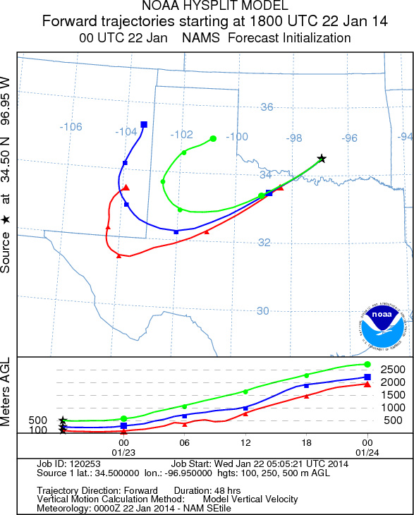
Trajectory weather: Air mass trajectories over southern Oklahoma will begin the day under sunny skies with
moderate to strong winds from the northeast. Temperatures will be in the mid-50s and should be good for pollen
release. The northeast winds, however will be bringing very cold air into the region and thus by evening temperatures
will be dropping. Tonights lows in southern Oklahoma will be in the low 20. The trajectories move to the southwest
as the northeasterly winds move in. the dense cold air will lift the atmosphere as it invades and thus some entrainment
and travel is expected from the trajectories. The air will move to the southeast and then curl around the edge
of the atmospheric push, bring the trajectories over northwestern Texas in the Pan Handle area. The air mass change
will occur late afternoon and into the evening with cloudy skies building in and temperatures dropping. Winds
will establish themselves from the northeast across the region overnight with strong gusty conditions expected.
Tomorrow skies will be cloudy with a chance of precipitation across Texas. In Oklahoma partly cloudy skies will
occur but temperatures will remain firmly in the 30s. Tomorrow night lows will drop into the low teens. Tomorrow
daytime temperatures will be well below the threshold for pollen release.
OUTLOOK: *** High Threat Today and Low Threat Tomorrow
*** Conditions for pollen release today remain at moderate levels with temperatures expected to get into the
mid-50s across southern Oklahoma. However, the timing of the push of cold air will determine the amount of pollination
that occurs as cold temperatures are moving into the area. Tonight lows in southern Oklahoma are expect to be
in the low 20s. Temperatures tomorrow will only warm slightly with the high expected in the low 30s. Winds will
be moderate from the northeast and the air will be cold and dense at the ground surface. The trajectories appear
to move southwesterly and then circle around the edge of the dense air push into the Texas Pan Handle area. The
northerly flow will keep surface pollen mostly over the population. If it gets entrained it will move over the
denser ground level cold air. It does not appear that today will be a significant exporter of pollen from the
region and the populations in southern Oklahoma will struggle to get pollen out before the cold conditions begin
to drop the air temperature. Tomorrow high temperatures are not expected to get above the low 30s, very poor
conditions for any pollen release. However indications are that pollen remains ready to be released and entrained
into the atmosphere. High levels continue to be recorded at reporting stations across the region over the past
few days.
Trajectory Start (s) (shown by black
star on map): Davis, OK.
Prepared by: Estelle
Levetin
(Faculty
of Biological Science, The University of Tulsa, 800 S. Tucker Dr., Tulsa, OK 74104) and Peter
K Van de Water
(Department of Earth and Environmental Science, California State University Fresno, 2576 East San Ramon Avenue,
M/S ST24, Fresno CA 93740-8039). This forecast gives the anticipated future track of released Mountain Cedar pollen,
weather conditions over the region and along the forecast pathway, and an estimated time of arrival for various
metropolitan areas.
Questions: Aerobiology Lab e-mail: pollen@utulsa.edu
Return to Forecasting Home Page